


Get to know Datong Township
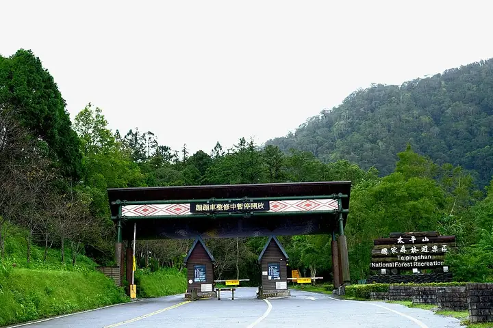
Photo adjustments
Full-frame source proportionally resized and converted to WebP for display. No subject alteration. Source-supplied marks and edits remain; cards may crop the view.
- Administrative area
- Rural township · 鄉
- Part of
- Yilan County
- Chinese name
- 大同鄉
- Local areas
- Rural township guide
Setting and landscape
The township's rivers run from the south-west towards the east and on to the Pacific. It borders New Taipei, Taoyuan and Taichung, and Chinese Wikipedia notes that it is the only county-level area in Taiwan next to three special municipalities. The township office describes three climate zones: villages near the plain, such as Lunpi (崙埤) and Songluo (松羅), average about 22°C, while the higher Taiping and Nanshan (南山) areas average about 18°C and see frost and snow in January and February. August to November is the rainy season and brings more than half the year's rain.
History
Under Japanese rule this was Indigenous territory administered by Luodong District (羅東郡). After the war it became Zhuoshui Township (濁水鄉), named after the Zhuoshui River, today's Lanyang River; in 1947 it was renamed Taiping after Mount Taiping (太平山), and in 1958 lots were drawn for a new name because Taichung County also had a Taiping Township. Logging in the Taipingshan forests drew workers to Taiping village until the forestry office withdrew logging in July 1977. Two stone tablets erected in November 1933 at the site of the Hanxi Shrine (寒溪神社) bear witness to Japanese rule over Indigenous villages; they became a county monument on 31 July 2013. Tunnel No. 8 of the Luodong Forest Railway (羅東森林鐵路), beside the Lanyang River near Zhinao (智腦), was registered as a historic building in 2012 and shelters Formosan leaf-nosed bats.
What to see
The township office lists the Taipingshan and Qilan (棲蘭) forest recreation areas, Renze Hot Spring (仁澤溫泉) and Cuifeng Lake (翠峰湖) in Taiping village, Fanfan Creek hot spring (梵梵溪溫泉) in Yingshi (英士), Songluo Lake (松羅湖), and the Siyuan Pass (思源啞口) viewing area in Nanshan. Mingchi (明池) lies in Yingshi village. The Atayal Bridge (泰雅大橋), completed in March 1997, crosses the Lanyang River from Lunpi to Tiansongpi (天送埤) in Sanxing (三星).
Food and local products
Cold, damp Siji (四季) and Nanshan grow high-altitude vegetables. Songluo has the Yulan (玉蘭) leisure farming area with tea gardens, Leshui (樂水) has a makino bamboo-shoot area, Fuxing has a trout leisure area, and Hanxi, Fuxing, Yingshi and Leshui grow citrus and plums.
Highlights
- Taipingshan National Forest Recreation Area 太平山國家森林遊樂區: Forest recreation area in Taiping village, the former logging centre.
- Mingchi 明池: In Yingshi village.
- Cuifeng Lake 翠峰湖: Listed by the township office among Taiping village's sights.
- Hanxi Shrine site 寒溪神社: Two 1933 stone tablets; county monument since 2013.
- Luodong Forest Railway Tunnel No. 8 羅東林鐵八號隧道: Historic building since 2012, home to Formosan leaf-nosed bats.
Sources for this guide
大同乡 (台湾) - 维基百科,自由的百科全书 · Chinese Wikipedia · CC BY-SA 4.0
宜蘭縣大同鄉公所-鄉政簡介 · Datong Township Office, Yilan County
Original English written from the listed sources and checked sentence by sentence against quoted extracts by a separate reviewer. Updated 2026-09-25.
Explore Datong Township
Core places to explore, with English and Chinese names.
Places to explore around Datong Township
Entrance to Taipingshan National Forest Recreation Area · 太平山国家森林游乐区入口 Source-recorded photograph date: 2015-08-30.Taipingshan National Forest Recreation Area太平山國家森林遊樂區
Taipingshan in Yilan combines mountain forest, a former forestry railway, hot springs and highland-lake scenery.
Read the place guide →Taipingshan National Forest Recreation Area · 太平山国家森林游乐区 Source-recorded photograph date: 2015-08-30.Taipingshan National Forest Recreation Area太平山森林游乐区
Taipingshan (太平山森林游乐区) is a mountain forest recreation area in Yilan's Datong Township, shaped by a century of forestry.
Read the place guide → Mingchi lake and forest scenery · 明池湖泊与森林景观 Source-recorded photograph date: 2015-11-28 13:21:43.
Mingchi Forest Recreation Area明池
Mingchi (明池) is a small mountain lake and forest recreation landscape in Datong Township, close to the Yilan–Taoyuan boundary on the Northern Cross-Island Highway.
Read the place guide →Plan your visit
Getting there
Datong Township is about 15 km in a straight line from central Yilan County. Search for 大同鄉 in a map app to find stations and your accommodation.
Where to stay →Build your route
Taipingshan National Forest Recreation Area and Mingchi Forest Recreation Area are both listed here. The linked place guides have entrance and visit details.
Continue with Yilan County →More in Yilan County
Sources & geographic information
Administrative names and parent areas: Official geographic directory · Reference date 2026-09-06.
Some facts checked against 大同乡 (台湾) — Wikipedia contributors, CC BY-SA 4.0.
Photo: Taipingshan National Forest Recreation Area · Taiwankengo · CC BY-SA 3.0. Full-frame source proportionally resized and converted to WebP for display. No subject alteration. Source-supplied marks and edits remain; cards may crop the view.

Photo: Taipingshan National Forest Recreation Area · Taiwankengo · CC BY-SA 3.0. Full-frame source proportionally resized and converted to WebP for display. No subject alteration. Source-supplied marks and edits remain; cards may crop the view.
Photo: Mingchi Forest Recreation Area · Jiashiang · CC BY 2.0. Full-frame source proportionally resized and converted to WebP for display. No subject alteration. Source-supplied marks and edits remain; cards may crop the view.

Map data © OpenStreetMap contributors. Pins mark approximate centres, not entrances or boundaries.