


Get to know Mainling
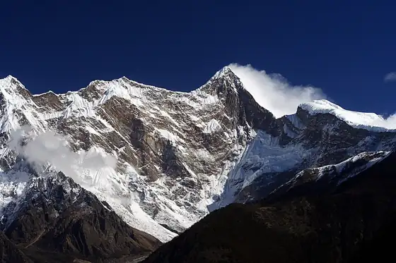
Photo adjustments
Resized and WebP compressed; subject not altered.
- Administrative area
- County-level city · 县级市
- Part of
- Nyingchi
- Chinese name
- 米林市
- Local areas
- County-level city guide
Area & population
- Area in the source
- 9,490.00 km²
- Population · 2020
- 26,176
Source: cited geographic source, as of the dates shown.
Setting and landscape
The city borders Medog County (墨脱县) to the southeast, Nang County (朗县) to the west, Bayi District (巴宜区) to the north and Gongbo'gyamda County (工布江达县) to the northwest. Its average elevation is 3,700 metres; the seat, Mainling town (米林镇), stands at about 2,940 metres. Mainling is the main home of the Lhoba (珞巴族) people, and the city includes the Nanyi Lhoba Ethnic Township (南伊珞巴民族乡).
History
Mainling County was created in August 1959 from the southwestern part of the old Zhelagang dzong (则拉岗宗), under Nyingchi. Its seat moved to Dongduo village (东多村) in May 1961. The county passed to Lhasa in 1964 and returned to Nyingchi when the prefecture was restored in 1983. In 2023 the county was abolished and replaced by the county-level city of Mainling.
What to see
The city government divides local scenery into three belts: the Yarlung Tsangpo Grand Canyon (雅鲁藏布大峡谷), the Nanyi valley, and the eastern Tibet loop. The canyon scenic area, 504.6 km long, opened on 24 July 2008 and was rated national 4A in January 2010; the city government ranks it with the Potala Palace and Everest among Tibet's three leading tourism resources. People's Daily Online's Tibet channel notes Kongpo Tibetan (工布藏族) and Monba (门巴族) villages inside the canyon, century-old peach trees that flower from mid-to-late March to early May, and views of Namcha Barwa (南迦巴瓦峰).
Suosong village (索松村) sits on a cliff hundreds of metres high, halfway up the slope facing Namcha Barwa with the canyon between them, among fields of highland barley. Nanyi Valley (南伊沟), opened to visitors in 2009, lies in Nanyi Lhoba Ethnic Township and is called the "Tibetan valley of the medicine king" (藏地药王谷). Its Zhagong gully (扎贡沟) holds 820 hectares of old-growth forest with more than 720 seed-plant species, several named after Mainling, such as the Mainling poplar.
Food and local products
Mainling Tibetan chicken (米林藏鸡) is a Chinese geographical-indication product, and Mainling jade (米林藏玉) is a stone produced in the city.
Getting oriented
The city seat is 72 km from Bayi (八一镇), the seat of Nyingchi, and 480 km from Lhasa. National Highway 219 crosses the city, the Lhasa–Nyingchi railway (拉林铁路) calls at Mainling station, and Nyingchi Mainling Airport (林芝米林机场) is listed among its transport links.
Highlights
- Yarlung Tsangpo Grand Canyon scenic area 雅鲁藏布大峡谷: 504.6 km long; opened on 24 July 2008 and rated national 4A in January 2010.
- Suosong village 索松村: Clifftop village facing Namcha Barwa across the canyon.
- Nanyi Valley 南伊沟: Forest valley in Nanyi Lhoba Ethnic Township, opened in 2009, called the "Tibetan valley of the medicine king".
- Mainling Tibetan chicken 米林藏鸡: Chinese geographical-indication product.
Sources for this guide
走进米林 - 米林市人民政府网 · Mainling City People's Government
景点介绍 - 米林市人民政府网 · Mainling City People's Government
环行藏东南 秘境南伊沟 - 米林市人民政府网 · Mainling City People's Government (report by China Tibet Online)
“醉美林芝” 十大打卡景点等你来 · People's Daily Online, Tibet channel
摄影师镜头下的索松村 - 米林市人民政府网 · Mainling City People's Government
米林市 - 维基百科 · Chinese Wikipedia · CC BY-SA 4.0
Original English written from the listed sources and checked sentence by sentence against quoted extracts by a separate reviewer. Updated 2026-09-25.
Entry & permits for Tibet (Xizang)
Foreign tourists need Tibet entry approval, commonly called a Tibet Travel Permit, and an organised visit arranged through a specialist travel agency in China. Confirm your approved route before booking transport. Requirements differ for Taiwan residents and for travellers using mainland or Hong Kong/Macao Chinese resident documents; check the document guide before you book.
Check the travel-document requirements →Policy scope verified: 2026-09-06. UK FCDO: China regional travel advice ↗ State Council Taiwan Affairs Office: Tibet entry approval ↗ Xizang Department of Culture and Tourism: Medog border permit notice ↗
Explore Mainling
Core places to explore, with English and Chinese names.
Places to explore around Mainling
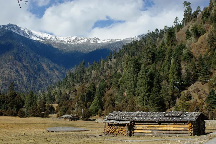 Snow-capped peaks and forested slopes above wooden cabins in Nanyi Valley, Mainling (Nyingchi) · 林芝米林南伊沟雪山森林与木屋 Source-recorded photograph date: 2012-12-01 18:27.
Nanyi Valley南伊沟
Nanyi Gully (南伊沟) is a forested valley in 南伊珞巴民族乡 in Mainling City, Nyingchi, Tibet, which the Mainling city government describes as a well-preserved, humid gully of towering old trees and rushing water, known as the medicine-king valley of Tibet and one of the main settlements of the Lhoba.
Read the place guide →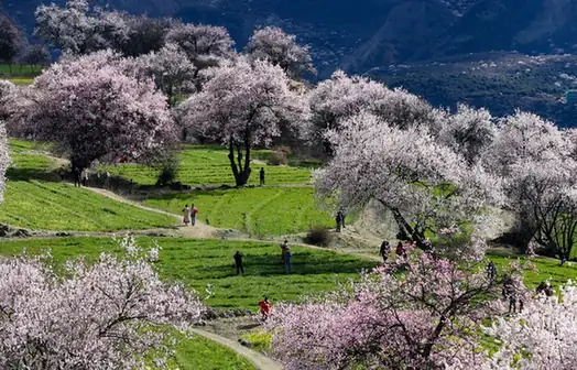 Suosong Village · 索松村
Suosong Village索松村
Suosong Village (索松村) is a village in 派镇 in Mainling City, Tibet, on a mountainside above the Yarlung Zangbo where the river runs through the Yarlung Zangbo Grand Canyon, with Namcha Barwa in view.
Read the place guide →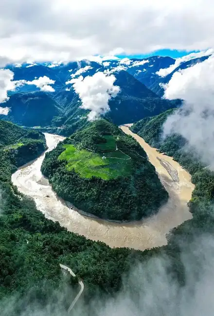 Yarlung Zangbo Grand Canyon Visitor Area · 雅鲁藏布大峡谷开放游览区
Yarlung Zangbo Grand Canyon Visitor Area雅鲁藏布大峡谷开放游览区
The Yarlung Zangbo Grand Canyon (雅鲁藏布大峡谷) is the gorge of the Yarlung Zangbo in Nyingchi, Tibet, and the entity the catalogue lists as 雅鲁藏布大峡谷开放游览区 is the Yarlung Zangbo Grand Canyon tourist area, a national 5A-level scenic area in 派镇 in Mainling City.
Read the place guide →Plan your visit
Getting there
Mainling is about 15 km in a straight line from central Nyingchi. Search for 米林市 in a map app to find stations and your accommodation.
Where to stay →Build your route
Nanyi Valley and Suosong Village are both listed here. The linked place guides have entrance and visit details.
Continue with Nyingchi →More in Nyingchi
Sources & geographic information
Administrative names and parent areas: Official geographic directory · Reference date 2026-09-06.
Some facts checked against 米林市 — Wikipedia contributors, CC BY-SA 4.0.
Photo: Nanyi Valley · JL Cogburn · CC BY-SA 2.0. Full frame retained; proportionally resized and converted to WebP. No retouching or changes to the photographed subject. Card displays may crop the view.
.jpg)
Photo: Suosong Village · Source photographer · License not provided. EXIF orientation normalized; resized without changing aspect ratio; converted to WebP. No subject edits.
Photo: Yarlung Zangbo Grand Canyon Visitor Area · Source photographer · License not provided. EXIF orientation normalized; resized without changing aspect ratio; converted to WebP. No subject edits.
Map data © OpenStreetMap contributors. Pins mark approximate centres, not entrances or boundaries.