


Get to know Wensu County

Photo adjustments
Full frame retained; proportionally resized and converted to WebP. No retouching or changes to the photographed subject. Card displays may crop the view.
- Administrative area
- County · 县
- Part of
- Aksu Prefecture
- Chinese name
- 温宿县
- Local areas
- County guide
Area & population
- Area in the source
- 14,335.16 km²
- Population · 2020
- 266,002
- Administrative seat
- Wensu Town
Source: cited geographic source, as of the dates shown.
Setting and landscape
Tomur Peak stands on the border between Wensu and Kyrgyzstan; its Uyghur name means "iron", and the Chinese national map gives its height as 7,443 metres. The Tomur area holds 829 modern glaciers covering about 3,850 square kilometres, one of China's largest modern glacier areas, and the peak and surrounding mountains have been a nature reserve since 1980, later raised to national level. The Xinjiang government notes that the Tomur mountains are on the World Natural Heritage list. The county government counts 197 glaciers and 46 rivers in Wensu, yet average rainfall is under 100 mm a year; the county has long been called the "塞外江南" (a Jiangnan beyond the frontier).
History
Wensu appears in Western Han records as one of the 36 states of the Western Regions, and the county government says the name has not changed in more than 2,000 years; in Uyghur, Onsu means "ten rivers". The area came under the Han Protectorate of the Western Regions in 60 BC. In 1757 the Qing renamed the walled town of Wensu "Aksu"; in 1885 the main administration moved to a new city of Aksu, and the old town is today's Wensu county town. The county's Uyghur name still means "the old city of Aksu". Wensu County was set up in 1902, merged into Aksu County in 1958 and restored in 1962. The county government lists ancient tomb groups, the Gaolaozhuang site (高老庄遗址) and the Prince's Tomb (王子墓) among its historic remains.
What to see
The county's tourist sights include the Tianshan Shenmu Garden (天山神木园) and the Tomur Peak Grand Canyon (托木尔峰神奇大峡谷). The Xinjiang government describes the Tianshan Tomur scenic area and its grand canyon as popular with visitors from China and abroad.
Food and local products
The county government calls Wensu "China's Hometown of Rice" and "China's Hometown of Walnuts", and a UN-recognised production base of high-quality "green food" rice. It lists cotton, rice, livestock and orchard fruit as quality farm products, and the county holds the title of China Red Jujube Bio-industry Base.
Getting oriented
The Southern Xinjiang Railway, National Highway 314 and the Turpan-Hotan Expressway all cross the county, and the county town lies 3 km from Aksu airport.
Highlights
- Tomur Peak 托木尔峰: Highest summit of the Tian Shan, on the Wensu-Kyrgyzstan border; its name means "iron".
- Tomur Peak Grand Canyon 托木尔峰神奇大峡谷: Listed among the county's tourist sights; the Xinjiang government notes its popularity with visitors from China and abroad.
- Tianshan Shenmu Garden 天山神木园: Listed among the county's tourist sights.
Sources for this guide
温宿县人民政府 温宿概况 · Wensu County People's Government
温宿县人民政府 自然地理 · Wensu County People's Government
温宿县人民政府 历史人文 · Wensu County People's Government
温宿县人民政府 自然资源 · Wensu County People's Government
阿克苏着力打造全疆文旅产业融合发展基地 · Xinjiang Uygur Autonomous Region People's Government
托木尔峰 · Wikipedia · CC BY-SA 4.0
温宿县 · Wikipedia · CC BY-SA 4.0
Wensu County · Wikipedia · CC BY-SA 4.0
Original English written from the listed sources and checked sentence by sentence against quoted extracts by a separate reviewer. Updated 2026-09-25.
Explore Wensu County
Core places to explore, with English and Chinese names.
Places to explore around Wensu County
 AI illustration · AI 示意图(仅供参考,非该地点实拍)
Tianshan Tomur Tourism Area天山托木尔旅游区
The Tomur tourism area in Wensu links the Tamu village landscape with the separate Tomur Grand Canyon.
Read the place guide →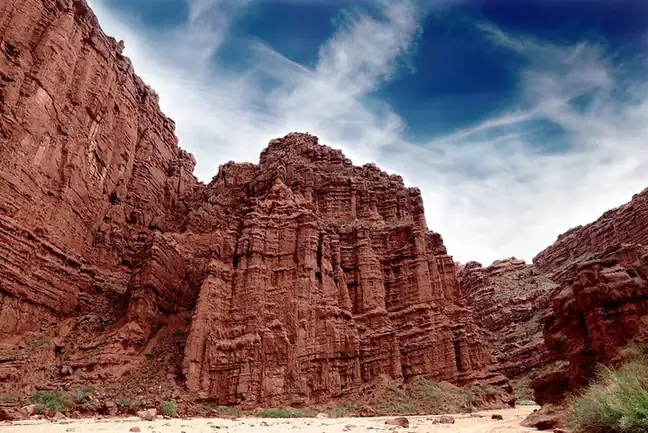 Tianshan Tomur Grand Canyon · 天山托木尔大峡谷
Tianshan Tomur Grand Canyon天山托木尔大峡谷
The Tomur Grand Canyon (天山托木尔大峡谷), also called the Kuduluke Grand Canyon (库都鲁克大峡谷), is a natural scenic area in Wensu County (温宿县), Aksu Prefecture (阿克苏地区), Xinjiang, where a set of named landforms is gathered.
Read the place guide → Ta Village · 塔村
Ta Village塔村
Ta Village (塔村) is the short name of Tagelake Village (塔格拉克村) in Kekeya township (柯柯牙镇), Wensu County (温宿县), Aksu Prefecture (阿克苏地区), Xinjiang — a village at the foot of Tomur Peak (托木尔峰), the highest peak of the Tianshan, whose economy now runs largely on rural tourism.
Read the place guide →Plan your visit
Getting there
Wensu County is about 9 km in a straight line from central Aksu Prefecture. Search for 温宿县 in a map app to find stations and your accommodation.
Where to stay →Build your route
Tianshan Tomur Tourism Area and Tianshan Tomur Grand Canyon are both listed here. The linked place guides have entrance and visit details.
Continue with Aksu Prefecture →More in Aksu Prefecture
Sources & geographic information
Administrative names and parent areas: Official geographic directory · Reference date 2026-09-06.
Some facts checked against 托木尔峰 — Wikipedia contributors, CC BY-SA 4.0.
Some facts checked against 温宿县 — Wikipedia contributors, CC BY-SA 4.0.
Some facts checked against Wensu County — Wikipedia contributors, CC BY-SA 4.0.
Photo: Tianshan Tomur Grand Canyon · landagent · CC BY-SA 3.0. EXIF orientation normalized; resized without changing aspect ratio; converted to WebP. No subject edits.

Photo: Ta Village · Source photographer · License not provided. EXIF orientation normalized; resized without changing aspect ratio; converted to WebP. No subject edits.
Map data © OpenStreetMap contributors. Pins mark approximate centres, not entrances or boundaries.