

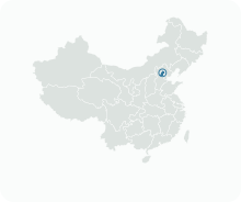
Get to know Pinggu District
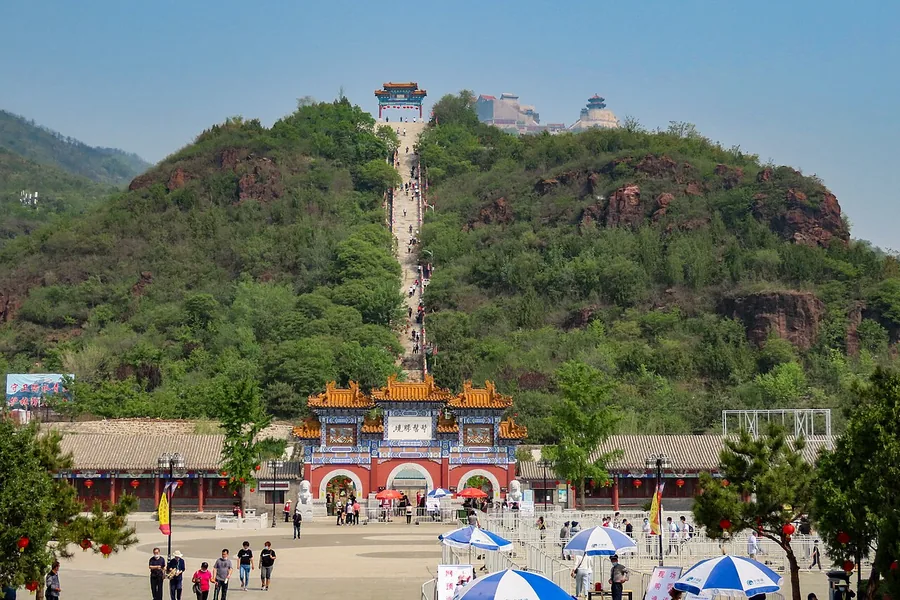
Photo adjustments
Proportionally resized and converted to WebP without cropping, retouching or changing the photographed subject.
- Administrative area
- District · 市辖区
- Part of
- Beijing
- Chinese name
- 平谷区
- Local areas
- District guide
Area & population
- Area in the source
- 950.00 km²
- Population · 2020
- 457,313
Source: cited geographic source, as of the dates shown.
History
A Pinggu County was first set up under the Western Han in 195 BC, within Yuyang Commandery (渔阳郡), with its seat south of present-day Xiaobeiguan village (小北关村) in Shandongzhuang town (山东庄镇). The county was later abolished, and under the Jin dynasty in 1187 Dawang town (大王镇) was raised to a county again. Pinggu belonged to Shuntian Prefecture (顺天府) under the Ming and Qing, and on 30 December 2001 it changed from a county to a district of Beijing, together with Huairou (怀柔).
Locals speak Pinggu dialect (平谷话), whose best-known trait is that the first and second tones of standard Mandarin swap places.
What to see
Jinhai Lake (金海湖), in Jinhaihu town, is a national 4A scenic area with 6.5 square kilometres of water ringed by hills on three sides; its named sights include the Huguang Pagoda (湖光塔), the tomb of Princess Jinhua (金花公主墓) and the Wanghai Pavilion (望海亭). Yaji Mountain (丫髻山) in Liujiadian town is a Taoist mountain whose Taoist tradition began in the Tang, peaked under the Yuan, Ming and Qing, and served the Qing court as a place of sacrifice. Its temple fair, held from the first to the eighteenth day of the fourth lunar month, has run for more than 500 years.
The Jingdong Grand Canyon (京东大峡谷) in Shandongzhuang town combines the canyon and Jingtai Mountain (井台山) scenic areas, with five pools strung along the gorge and a glass walkway built on the Wanzhang Cliff (万丈崖). Jingdong Shilinxia (京东石林峡), in Huangsongyu township, is known for its clusters of stone pinnacles and a glass viewing platform shaped like a flying saucer on the summit. Like Jinhai Lake and Yaji Mountain, both are national 4A scenic areas.
Food and local products
Pinggu peaches (平谷大桃) are a Beijing geographical-indication product. Wikipedia, drawing on the World Intellectual Property Organization, reports that in 2009 orchards covered more than 6,000 hectares with over 200 varieties, and that the peach was registered in 2002 as the first agricultural geographical indication in China. Two other fruits carry geographical indications: the Maoshanhou Fojianxi pear (茅山后佛见喜梨), a national product, and the Beizhai red apricot (北寨红杏), a Beijing one.
Highlights
- Jinhai Lake 金海湖: National 4A scenic area with 6.5 square kilometres of water, the Huguang Pagoda and the tomb of Princess Jinhua.
- Yaji Mountain 丫髻山: Taoist mountain used by the Qing court for sacrifices; its spring temple fair has run for more than 500 years.
- Jingdong Grand Canyon 京东大峡谷: Gorge with five pools and a glass walkway on the Wanzhang Cliff.
- Jingdong Shilinxia 京东石林峡: Stone-pinnacle scenery with a flying-saucer-shaped glass platform on the summit.
- Pinggu peaches 平谷大桃: Geographical-indication peaches, grown in more than 200 varieties.
Sources for this guide
金海湖景区 · Pinggu District People's Government, Beijing
丫髻山景区 · Pinggu District People's Government, Beijing
石林峡景区 · Pinggu District People's Government, Beijing
京东大峡谷景区 · Pinggu District People's Government, Beijing
平谷区 - 维基百科,自由的百科全书 · Wikipedia · CC BY-SA 4.0
Pinggu, Beijing - Wikipedia · Wikipedia · CC BY-SA 4.0
Original English written from the listed sources and checked sentence by sentence against quoted extracts by a separate reviewer. Updated 2026-09-25.
Explore Pinggu District
Core places to explore, with English and Chinese names.
Places to explore around Pinggu District
 Haizi Reservoir, the main lake of Beijing's Jinhai Lake scenic area in Pinggu.
Jinhai Lake金海湖
Jinhai Lake, also known as Haizi Reservoir, is a broad water landscape in eastern Pinggu surrounded by mountains on three sides. Huguang Pagoda, Wanghai Pavilion, and the Juchiya or Jagged Cliff area give the reservoir…
Read the place guide → Water and rocky banks inside Beijing's Jingdong Grand Canyon.
Jingdong Grand Canyon京东大峡谷
Jingdong Grand Canyon in Pinggu joins a deep-canyon scenic area with the wooded Jingtai Mountain zone. Lakes and distinct pools occupy the lower landscape, while the higher area offers a different forest-and-viewpoint…
Read the place guide →The long stairway and hilltop temples of Yaji Mountain seen from the entrance.Yaji Mountain丫髻山
Yaji Mountain in Pinggu is a Taoist landscape whose twin peaks were likened to a girl’s hair buns. Religious buildings occupy several levels from the foothill to the summits, with Bixia Yuanjun Temple and the Jade Emperor…
Read the place guide →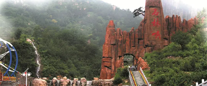 Jingdong Shilinxia Gorge · 京东石林峡
Jingdong Shilinxia Gorge京东石林峡
Jingdong Shilinxia is a rocky gorge in Huangsongyu, Pinggu District, east of Beijing.
Read the place guide →Plan your visit
Getting there
Pinggu District is about 65 km in a straight line from central Beijing. Search for 平谷区 in a map app to find stations and your accommodation.
Where to stay →Build your route
Jinhai Lake and Jingdong Grand Canyon are about 15 km apart in a straight line. The linked place guides have entrance and visit details.
Continue with Beijing →More in Beijing
Sources & geographic information
Administrative names and parent areas: Official geographic directory · Reference date 2026-09-06.
Some facts checked against 平谷区 — Wikipedia contributors, CC BY-SA 4.0.
Some facts checked against Pinggu, Beijing — Wikipedia contributors, CC BY-SA 4.0.
Photo: Jinhai Lake · Charlie fong · CC BY-SA 4.0. Proportionally resized and converted to WebP without cropping, retouching or changing the photographed subject.

Photo: Jingdong Grand Canyon · 高晶 (Chinese Wikipedia) · CC BY-SA 3.0. Proportionally resized and converted to WebP without cropping, retouching or changing the photographed subject.

Photo: Yaji Mountain · N509FZ · CC BY-SA 4.0. Proportionally resized and converted to WebP without cropping, retouching or changing the photographed subject.
.jpg)
Photo: Jingdong Shilinxia Gorge · Source photographer · License not provided. EXIF orientation normalized; resized without changing aspect ratio; converted to WebP. No subject edits.
Map data © OpenStreetMap contributors. Pins mark approximate centres, not entrances or boundaries.