


Get to know Shaoguan
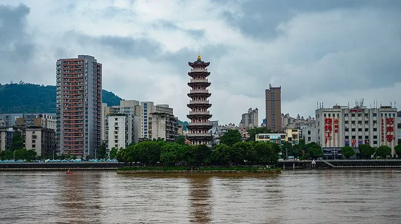
Photo adjustments
Full frame retained; proportionally resized and converted to WebP. No retouching or changes to the photographed subject. Card displays may crop the view.
- Administrative area
- Prefecture-level city · 地级市
- Part of
- Guangdong
- Chinese name
- 韶关市
- Local areas
- 10 local areas
Area & population
- Area in the source
- 18,645.00 km²
- Population · 2020 census
- 2,855,131
- Administrative seat
- Zhenjiang District
Source: cited geographic source, as of the dates shown.
Setting and landscape
Three arcs of mountains, running mainly east to west, follow one another from north to south, with the Nanxiong, Lechang, Shaoguan and Wengyuan basins between them; plains and terraces make up only a fifth of the land. Shikengkong (石坑崆) reaches 1,902 metres. The rock north of the city centre is mostly red and full of fossils, and the city government calls Shaoguan a world-famous home of red-bed dinosaurs.
History
In 1958 a human skull dated to 129,000 years ago was found in a cave near Maba (马坝) in Qujiang (曲江区) and named Maba Man (马坝人); the Shixia site (石峡遗址) beside it gave its name to a late Neolithic culture, and the two are listed together as a national key heritage site. Legend says Emperor Shun played Shao music on the red rocks here, the origin of the name Shaozhou (韶州), used from 589. The name Shaoguan came in the Ming and Qing, when three tax passes were set up in the city.
Hakka is the main dialect and Cantonese the second. The city government calls Shaoguan the birthplace of the overseas Yao. The Yao Panwang Festival (盘王节), on the first national intangible heritage list in 2006 and safeguarded in Ruyuan Yao Autonomous County (乳源瑶族自治县), honours King Pan with rites led by four ritual masters and the singing of the long epic Panwang Dage (盘王大歌).
What to see
Mount Danxia is part of the China Danxia World Heritage Site, and its administration calls it the place that named Danxia landforms worldwide. Nanhua Temple (南华寺), beside the Cao stream south of Maba and founded in the sixth century, is where the Sixth Patriarch Huineng (惠能) spread Southern Chan; his seated image in the Sixth Patriarch Hall is built up over his body in dry lacquer. Other sights include Yunmen Temple (云门大觉禅寺) and the Grand Canyon (大峡谷) in Ruyuan, the Mantang Hakka enclosure (满堂客家大围) in Shixing (始兴县), a national key heritage site, and the Meiguan ancient road (梅关古道) and Zhuji Lane (珠玑巷) in Nanxiong (南雄市).
Food and local products
Cold-water pork tripe (冷水猪肚) from Longgui (龙归) in Wujiang District (武江区) is boiled over a fierce fire and then steeped in cold well water, which makes it crisper. Nanxiong is known for its ducks, and duck braised with sour bamboo shoots and chilli (酸笋焖鸭), a Hakka dish of the Shaoguan area, is fried golden, braised until soft and said to taste better when left for a later meal.
Highlights
- Mount Danxia 丹霞山: Part of the China Danxia World Heritage Site; the place that gave its name to Danxia landforms.
- Nanhua Temple 南华寺: Temple near Maba in Qujiang where Huineng spread Southern Chan; holds his lacquered seated image.
- Maba Man site 马坝人遗址: Cave near Maba where a 129,000-year-old human skull was found in 1958; national key heritage site with the Shixia site.
- Mantang Hakka enclosure 满堂客家大围: Hakka enclosure in Shixing County, a national key heritage site.
- Cold-water pork tripe 冷水猪肚: Longgui dish of tripe boiled hard and steeped in cold well water.
Sources for this guide
自然地理 - 韶关市人民政府门户网站 · Shaoguan Municipal People's Government
历史人文 - 韶关市人民政府门户网站 · Shaoguan Municipal People's Government
建置区划 - 韶关市人民政府门户网站 · Shaoguan Municipal People's Government
韶关市 广东省人民政府门户网站 · People's Government of Guangdong Province (text from the Guangdong Provincial Tourism Administration)
世遗十六载 校地共守护!丹霞山开展中国丹霞16周年庆祝活动 - 丹霞山风景名胜区官方网站 · Danxiashan Administrative Committee, Shaoguan
瑶族盘王节 - 中国非物质文化遗产网·中国非物质文化遗产数字博物馆 - 中国非物质文化遗产网非遗 · China Intangible Cultural Heritage Network (China National Center for the Safeguarding of Intangible Cultural Heritage)
冷水猪肚 广东省人民政府门户网站 · People's Government of Guangdong Province (text from the Guangdong Provincial Tourism Administration)
酸笋焖鸭 广东省人民政府门户网站 · People's Government of Guangdong Province (text from the Guangdong Provincial Tourism Administration)
南华寺 (韶关) - 维基百科,自由的百科全书 · Wikipedia (Chinese) · CC BY-SA 4.0
韶关市 - 维基百科,自由的百科全书 · Wikipedia (Chinese) · CC BY-SA 4.0
Original English written from the listed sources and checked sentence by sentence against quoted extracts by a separate reviewer. Updated 2026-09-30.
Explore Shaoguan
Core places to explore, with English and Chinese names.
Danxia Mountain 丹霞山
Nanhua Temple 南华寺
Shaoguan Museum 韶关市博物馆
Nine Rapids and Eighteen Shoals Scenic Area 九泷十八滩开放游览区
Yunmen Temple 云门寺
Guangdong Grand Canyon 广东大峡谷
Meiguan Ancient Road 梅关古道
Maozifeng Forest Farm 帽子峰林场
Zhuji Ancient Lane 珠玑古巷
Mantang Hakka Walled Compound 满堂客家大围
Yunji Mountain 云髻山
Maba Man Site 马坝人遗址
Wujiang District 武江区
Zhenjiang District 浈江区
Qujiang District 曲江区
Shixing County 始兴县
Renhua County 仁化县
Wengyuan County 翁源县
Ruyuan Yao Autonomous County 乳源瑶族自治县
Xinfeng County 新丰县
Lechang 乐昌市
Nanxiong 南雄市
Places to explore around Shaoguan
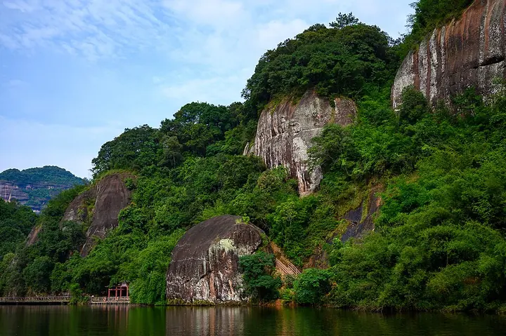 Red-rock cliffs and water at Danxia Mountain · 丹霞山 Photograph date recorded by the source: 22 June 2019, 16:47.
Danxia Mountain丹霞山
Danxia Mountain is defined by red sandstone cliffs rising above narrow valleys and a winding river. Erosion has separated the rock into towers and distinctive formations, including Yangyuan Stone, while paths and temple sites…
Read the place guide →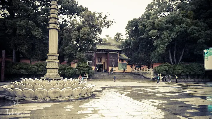 The forecourt of Nanhua Temple in Shaoguan · 南华寺 Photograph date recorded by the source: Taken on 21 November 2012.
Nanhua Temple南华寺
Nanhua Temple is a Chan Buddhist monastery at Maba in Shaoguan’s Qujiang district. It is closely associated with Huineng, the Sixth Patriarch of Chan Buddhism, who lived and taught here. That connection makes the temple a…
Read the place guide → Shaoguan Museum · 韶关市博物馆
Shaoguan Museum韶关市博物馆
Shaoguan Museum is particularly useful for seeing everyday activities represented in ancient pottery. Its regional collections include brown-glazed models of ploughing and working rice fields, with small human figures and oxen…
Read the place guide → Nine Rapids and Eighteen Shoals Scenic Area · 九泷十八滩开放游览区
Nine Rapids and Eighteen Shoals Scenic Area九泷十八滩开放游览区
Jiulong Shibatan (九泷十八滩), the 'nine chutes and eighteen shoals', is a designated scenic stretch of the Wu River in Lechang, Shaoguan, Guangdong, running 61 kilometres between Pingshi town and Lecheng town. Guangdong province declared it a provincial scenic and historic area in May 1993.
Read the place guide → Yunmen Temple (云门寺), Ruyuan Yao Autonomous County. Photograph: "Yunmen Temple front".
Yunmen Temple云门寺
Yunmen Temple (云门寺), properly Yunmenshan Dajue Chan Temple, sits at Yunmen village in Yucheng town, Ruyuan Yao Autonomous County, Shaoguan, Guangdong. It is the birthplace and root monastery of the Yunmen school, one of the five houses of Chan Buddhism, and a working monastery rather than a museum.
Read the place guide →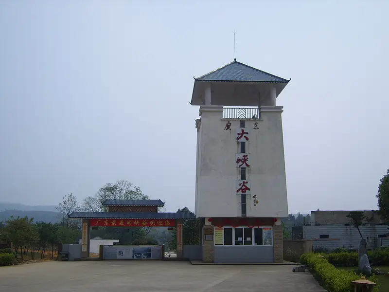 Guangdong Grand Canyon · 广东大峡谷
Guangdong Grand Canyon广东大峡谷
Guangdong Grand Canyon (广东大峡谷), also called Ruyuan Grand Canyon, is a steep-sided gorge in the hills of south-western Ruyuan Yao Autonomous County, Shaoguan, Guangdong. It is protected as the Guangdong Ruyuan Grand Canyon Provincial Nature Reserve, which covers 4,021.9 hectares.
Read the place guide → The Meiguan gate on the ancient Meiguan road, Nanxiong · 南雄梅关古道梅岭雄关关楼 Source-recorded photograph date: 2014-01-12 13:57:42.
Meiguan Ancient Road梅关古道
Meiguan Gudao (梅关古道) is the surviving stretch of the old post road over Meiling, also known as Dayuling, in the north of Nanxiong, Shaoguan, Guangdong, on the boundary with Jiangxi. The pass, at over 700 metres, was for centuries the main land link between the Yangtze and Pearl River systems.
Read the place guide →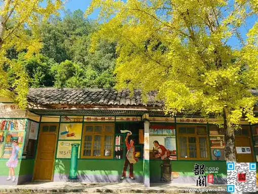 Maozifeng Forest Farm · 帽子峰林场
Maozifeng Forest Farm帽子峰林场
Maozifeng Forest Farm (帽子峰林场) is a state forest unit in Nanxiong, Shaoguan, Guangdong, whose grounds form the Maozifeng provincial forest park. It is best known for the ginkgo trees that turn gold in late autumn.
Read the place guide →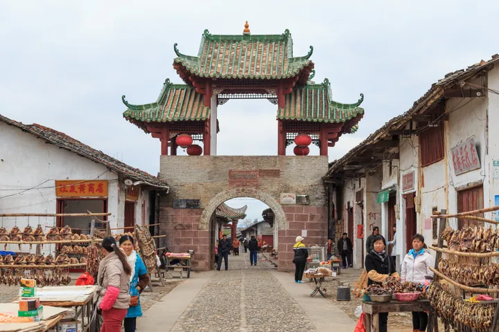 The gate tower of Zhuji Ancient Lane (Zhu Ji Gu Xiang), Nanxiong, over the historic street lined with vendors · 韶关市南雄市珠玑古巷门楼及老街 Source-recorded photograph date: 2014-01-12 10:28:38.
Zhuji Ancient Lane珠玑古巷
Zhuji Ancient Lane (珠玑古巷) is a cobbled street in Zhuji town, Nanxiong, Shaoguan, Guangdong, remembered as the staging point from which families who had crossed the Meiling pass moved on into the Pearl River Delta. It is regarded as an ancestral home of the Guangfu, the Cantonese-speaking people of the delta.
Read the place guide →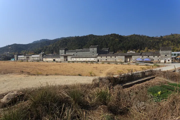 The walled Hakka compound of Mantang Hakka Walled Compound (Mantang Wei) in Shixing County, Shaoguan · 韶关市始兴县满堂客家大围远眺 Source-recorded photograph date: 2014-01-11 12:58:00.
Mantang Hakka Walled Compound满堂客家大围
Mantang Hakka Great Wei (满堂客家大围) is a fortified Hakka walled residence at Mantang village in Aizi town, Shixing County, Shaoguan, Guangdong. Built between 1833 and 1860, it is a national key cultural relics protection unit and one of the largest square-plan weilou in Lingnan.
Read the place guide →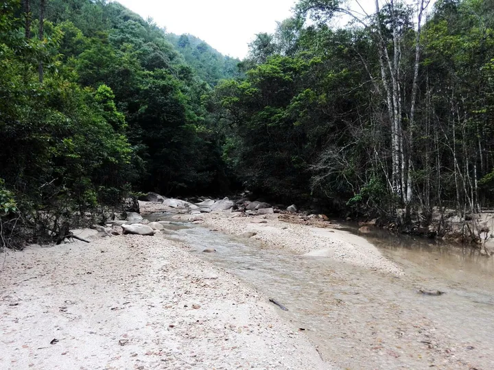 A forest stream in the Yunji Mountain nature reserve, Xinfeng County · 云髻山自然保护区林间溪流,新丰县 Source-recorded photograph date: Taken on 28 June 2014.
Yunji Mountain云髻山
Yunji Shan (云髻山) rises in the middle of Xinfeng County, Shaoguan, Guangdong, about eight kilometres north-west of the county town. Its main peak reaches 1,438.8 metres and is the source of the Xinfeng River; the mountain is protected as a provincial nature reserve of 2,700 hectares.
Read the place guide → Main entrance gate of the Maba Man Site Park in Qujiang District, Shaoguan · 韶关市曲江区马坝人遗址公园大门 Source-recorded photograph date: 2 February 2006 (original upload date).
Maba Man Site马坝人遗址
Twin limestone hills near Maba, Shaoguan, where a 1958 skull find named Maba Man and the Neolithic Shixia site share one national listing.
Read the place guide →Local life & food
Shaoguan local specialties
韶关市特色美食 · 10 specialties to discover
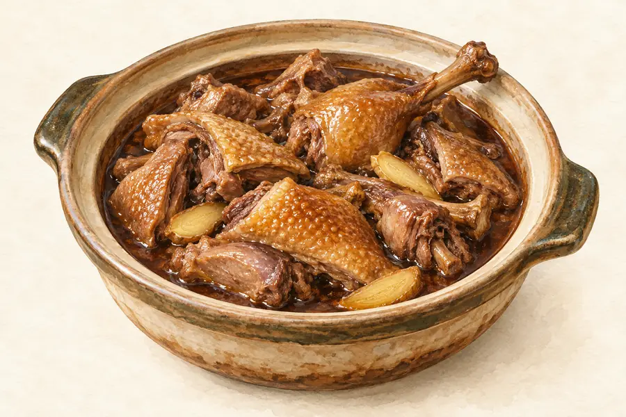 Nanxiong Duck with Sour Bamboo Shoots 南雄酸笋鸭AI illustration · AI 示意图(仅供参考,非实拍)
Nanxiong Duck with Sour Bamboo Shoots (南雄酸笋鸭) is duck cooked with pickled bamboo shoots and chilli in Nanxiong (南雄), in the Shaoguan (韶关) area of northern Guangdong.
Read the dish guide →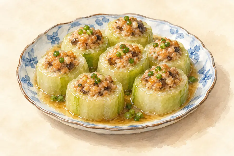 Nanxiong Stuffed Tofu 南雄酿豆腐AI illustration · AI 示意图(仅供参考,非实拍)
Nanxiong Stuffed Tofu (南雄酿豆腐) is a Hakka (客家) dish of fried tofu puffs filled with a taro stuffing, from Nanxiong (南雄) in Shaoguan (韶关), northern Guangdong.
Read the dish guide →Meiling Spicy Braised Goose 梅岭鹅王AI illustration · AI 示意图(仅供参考,非实拍)
Meiling Spicy Braised Goose (梅岭鹅王) is a hot, numbing goose dish from Nanxiong (南雄) in Shaoguan (韶关), northern Guangdong. Its name means 'Meiling goose king'.
Read the dish guide →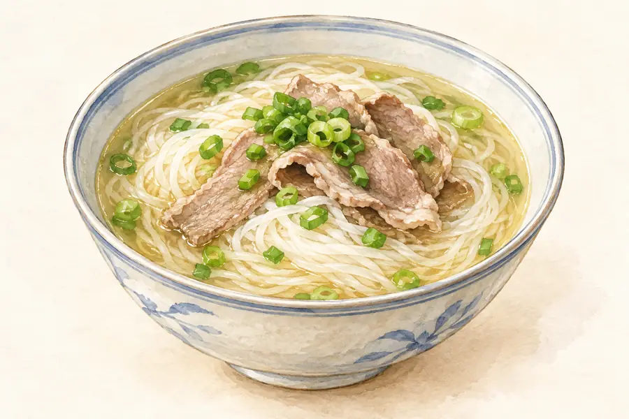 Shixing Zaixiang Rice Noodles 始兴宰相粉AI illustration · AI 示意图(仅供参考,非实拍)
Shixing Zaixiang Rice Noodles (始兴宰相粉) are dried rice noodles from Shixing County (始兴县) in Shaoguan (韶关), northern Guangdong, cut by hand from steamed sheets of rice batter and tied into bundles.
Read the dish guide →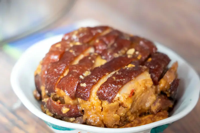 Renhua Shitang Steamed Pork Belly 仁化石塘扣肉
Renhua Shitang Steamed Pork Belly (仁化石塘扣肉) is the kourou (扣肉) of Shitang (石塘) ancient village in Renhua County (仁化县), Shaoguan (韶关): fried pork belly layered with fried taro, seasoned with the village's rice wine and steamed in a bowl.
Read the dish guide →Photo adjustments
EXIF orientation normalized; resized without changing aspect ratio; converted to WebP. No subject edits.
 Wengyuan Zhoubei Rice Dumplings 翁源周陂米饺
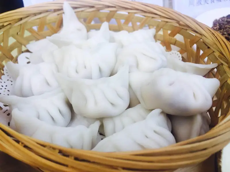
Wengyuan Zhoubei Rice Dumplings (翁源周陂米饺) are steamed dumplings with a wrapper made of rice instead of wheat flour, from Zhoubei (周陂) town in Wengyuan County (翁源县), Shaoguan (韶关), in northern Guangdong.
Read the dish guide →Photo adjustments
EXIF orientation normalized; resized without changing aspect ratio; converted to WebP. No subject edits.
 Ruyuan Stir-Fried Rock Chives and Cured Pork 乳源石韭菜炒腊肉AI illustration · AI 示意图(仅供参考,非实拍)
Ruyuan Stir-Fried Rock Chives and Cured Pork (乳源石韭菜炒腊肉) is a Yao (瑶族) dish from Ruyuan Yao Autonomous County (乳源瑶族自治县) in Shaoguan (韶关): shijiu (石韭), a mountain chive, stir-fried with the smoked cured pork of Yao households.
Read the dish guide → Lechang Water Chestnut Cake 乐昌马蹄糕AI illustration · AI 示意图(仅供参考,非实拍)
Lechang Water Chestnut Cake (乐昌马蹄糕) is a steamed, sliced water chestnut cake made with the water chestnuts of Lechang (乐昌), a county-level city of Shaoguan (韶关) at the far northern edge of Guangdong, on the southern slopes of the Nanling Mountains (南岭).
Read the dish guide →All dish names · 全部菜名 (10)
- Nanxiong Duck with Sour Bamboo Shoots · 南雄酸笋鸭
- Nanxiong Stuffed Tofu · 南雄酿豆腐
- Meiling Spicy Braised Goose · 梅岭鹅王
- Shixing Zaixiang Rice Noodles · 始兴宰相粉
- Renhua Shitang Steamed Pork Belly · 仁化石塘扣肉
- Wengyuan Zhoubei Rice Dumplings · 翁源周陂米饺
- Ruyuan Stir-Fried Rock Chives and Cured Pork · 乳源石韭菜炒腊肉
- Lechang Water Chestnut Cake · 乐昌马蹄糕
- Shaoguan Chilled Pork Tripe · 韶关冷水猪肚
- Hakka salt-baked chicken · 客家盐焗鸡
More dishes from across Guangdong are in the Guangdong food guide.
Counties & districts in Shaoguan
10 areas belong directly to Shaoguan.
10 areas
Wujiang District 武江区
Wujiang is a district of Shaoguan, Guangdong province, China.
Explore the area →DistrictZhenjiang District 浈江区
Zhenjiang District (simplified Chinese: 浈江区; traditional Chinese: 湞江區; pinyin: Zhēnjiāng Qū) is a district of Shaoguan, a city in northern Guangdong Province (Yuebei), China. Zhenjiang is seat of Shaoguan.
Explore the area →DistrictQujiang District 曲江区
Qujiang (postal: Kukong; Chinese: 曲江; pinyin: Qǔjiāng) is a district of Shaoguan, Guangdong province, China.
Explore the area →CountyShixing County 始兴县
Shixing County is a county of Shaoguan Prefecture in northern Guangdong Province in southeastern China. It borders Jiangxi Province to the east and Nanxiong Prefecture to the northeast.
Explore the area →Show fewer areas
Renhua County 仁化县
Renhua County (postal: Yanfa; simplified Chinese: 仁化县; traditional Chinese: 仁化縣; pinyin: Rénhuà Xiàn) is a county in the northernmost portion of Guangdong province, in China, bordering Jiangxi to the…
Explore the area →CountyWengyuan County 翁源县
Wengyuan (postal: Yungyun; Chinese: 翁源; pinyin: Wēngyuán) is a county in the north of Guangdong Province, China, bordering Jiangxi to the northeast. It is under the administration of Shaoguan City.
Explore the area →Autonomous countyRuyuan Yao Autonomous County 乳源瑶族自治县
Ruyuan (postal: Yuyuan; Chinese: 乳源; pinyin: Rǔyuán; Jyutping: jyu5 jyun4 jyun6), officially Ruyuan Yao Autonomous County, is a county of northern Guangdong province, China, with a small border with Hunan to…
Explore the area →CountyXinfeng County 新丰县
Xinfeng County (postal: Sunfung or Sinfeng; simplified Chinese: 新丰县; traditional Chinese: 新豐縣; pinyin: Xīnfēng Xiàn) is a county in the northeast of Guangdong Province, China.
Explore the area →County-level cityLechang 乐昌市
Lechang (simplified Chinese: 乐昌; traditional Chinese: 樂昌; pinyin: Lèchāng; historically Lokchong) is a county-level city in the northern Guangdong province, People's Republic of China, bordering Hunan…
Explore the area →County-level cityNanxiong 南雄市
Nanxiong, historically Namyung, Namhung, and Nanhsiung, is a county-level city of northern Guangdong province, People's Republic of China, bordering Jiangxi to the north, east and southeast.
Explore the area →No areas match this name.
Plan your visit
Getting there
Search for 韶关市 in a map app to find stations and your accommodation.
Where to stay →Build your route
Danxia Mountain and Nanhua Temple are about 45 km apart in a straight line. The linked place guides have entrance and visit details.
Continue with Guangdong →More in Guangdong
Sources & geographic information
Administrative names and parent areas: Official geographic directory · Reference date 2026-09-06.
Some facts checked against 南华寺 (韶关) — Wikipedia contributors, CC BY-SA 4.0.
Some facts checked against 韶关市 — Wikipedia contributors, CC BY-SA 4.0.
Photo: Danxia Mountain · xiquinhosilva · CC BY 2.0. Full frame retained; proportionally resized and converted to WebP. No retouching or changes to the photographed subject. Card displays may crop the view.
.jpg)
Photo: Nanhua Temple · 科技小辛 · CC BY-SA 3.0. Full frame retained; proportionally resized and converted to WebP. No retouching or changes to the photographed subject. Card displays may crop the view.
.jpg)
Photo: Shaoguan Museum · Source photographer · License not provided. EXIF orientation normalized; resized without changing aspect ratio; converted to WebP. No subject edits.
Photo: Nine Rapids and Eighteen Shoals Scenic Area · Source photographer · License not provided. EXIF orientation normalized; resized without changing aspect ratio; converted to WebP. No subject edits.
Photo: Yunmen Temple · No machine-readable author provided. Nat Krause assumed (based on copyright claims). · Public domain. Full frame retained; EXIF orientation normalized, proportionally resized to at most 800 pixels and converted to WebP. No generated pixels or subject changes. Cards may crop the display.

Photo: Guangdong Grand Canyon · Source photographer · License not provided. EXIF orientation normalized; resized without changing aspect ratio; converted to WebP. No subject edits.

Photo: Meiguan Ancient Road · Zhangzhugang · CC BY-SA 3.0. Full frame retained; proportionally resized and converted to WebP. No retouching or changes to the photographed subject. Card displays may crop the view.

Photo: Maozifeng Forest Farm · Source photographer · License not provided. EXIF orientation normalized; resized without changing aspect ratio; converted to WebP. No subject edits.
Photo: Zhuji Ancient Lane · Zhangzhugang · CC BY-SA 4.0. Full frame retained; proportionally resized and converted to WebP. No retouching or changes to the photographed subject. Card displays may crop the view.

Photo: Mantang Hakka Walled Compound · Zhangzhugang · CC BY-SA 3.0. Full frame retained; proportionally resized and converted to WebP. No retouching or changes to the photographed subject. Card displays may crop the view.

Photo: Yunji Mountain · Qiu Mao · CC BY 3.0. Full frame retained; proportionally resized and converted to WebP. No retouching or changes to the photographed subject. Card displays may crop the view.

Photo: Maba Man Site · The original uploader was Zhuwq at Chinese Wikipedia. · CC BY-SA 3.0. Full frame retained; proportionally resized and converted to WebP. No retouching or changes to the photographed subject. Card displays may crop the view.

Map data © OpenStreetMap contributors. Pins mark approximate centres, not entrances or boundaries.