


Get to know Wuhan

Photo adjustments
Full frame retained; proportionally resized and converted to WebP. No retouching or changes to the photographed subject. Card displays may crop the view.
- Administrative area
- Prefecture-level city · 地级市
- Part of
- Hubei
- Chinese name
- 武汉市
- Local areas
- 13 local areas
Area & population
- Area in the source
- 8,494.41 km²
- Population · 2022
- 13,739,000
- Administrative seat
- Jiang'an District
Source: cited geographic source, as of the dates shown.
Setting and landscape
Wuhan has a humid subtropical monsoon climate with four distinct seasons: cold winters and hot, rainy summers. East Lake (东湖), one of China's first national scenic areas, holds 33 square kilometres of lakes within the urban area.
History
Panlongcheng (盘龙城), beside Panlong Lake in Huangpi (黄陂), dates to the Shang dynasty some 3,500 years ago. In the Ming Chenghua reign the Han's mouth shifted from south to north of Tortoise Hill (龟山), which gave rise to Hankou; under the Qing it counted among China's four great commercial towns, and in 1861 it opened to foreign trade as a treaty port. Zhang Zhidong (张之洞), governor-general from 1889, built factories and schools and trained a Western-style army. On 10 October 1911 the revolution that brought down the Qing broke out in Wuhan, the Nationalist government moved its capital here in December 1926, and in 1954 Wuhan became the capital of Hubei.
What to see
The Yellow Crane Tower (黄鹤楼) on Snake Hill (蛇山) in Wuchang, one of the 'Three Famous Towers South of the Yangtze', rises five storeys and 51.4 metres under yellow glazed tiles. The Wuhan Yangtze River Bridge (武汉长江大桥), between Snake Hill and Tortoise Hill, opened in 1957 as the first road-and-rail bridge over the Yangtze. The city's travel account describes Ming-era Hubu Lane (户部巷), just north of the tower, as a lane of longstanding breakfast shops.
The Hubei Provincial Museum (湖北省博物馆) on Donghu Road has a collection including the bells of the Marquis Yi of Zeng (曾侯乙编钟) and the sword of King Goujian of Yue (越王勾践剑), excavated in Jiangling in 1965. A greenway of about 102 kilometres runs through the East Lake scenic area. In Huangpi, the Mulan area (木兰文化生态旅游区) groups Mulan Mountain (木兰山), Mulan Great Lake, Mulan Prairie and Mulan Yunwu Mountain (木兰云雾山), known for its azaleas. Han opera (汉剧), formed in the Qing and national intangible heritage since 2006, sings mainly to the xipi and erhuang tunes.
Food and local products
Eating breakfast is called guozao (过早) in Wuhan dialect, and for many residents that means hot dry noodles (热干面): alkaline noodles part-cooked, tossed in sesame oil and cooled, then reheated and dressed with sesame paste, soy sauce and diced spicy radish. The city government's Hubu Lane page also names tri-delicacy doupi (三鲜豆皮) and steamed dumplings among Wuhan's breakfast snacks.
Getting oriented
The city's transport guide lists Wuhan, Wuchang and Hankou railway stations and describes Wuhan Tianhe International Airport (武汉天河国际机场) as a regional aviation hub.
Highlights
- Yellow Crane Tower 黄鹤楼: Five-storey, 51.4 m tower on Snake Hill in Wuchang; national 5A site.
- Wuhan Yangtze River Bridge 武汉长江大桥: Opened 1957 between Snake Hill and Tortoise Hill; the first road-and-rail bridge over the Yangtze.
- Hubei Provincial Museum 湖北省博物馆: Holds the Marquis Yi of Zeng bells and the sword of King Goujian of Yue.
- East Lake 东湖: 33 sq km of lakes in the city, with a greenway of about 102 km through the scenic area.
- Hubu Lane 户部巷: Ming-era lane north of the Yellow Crane Tower, associated with breakfast shops.
- Hot dry noodles 热干面: Alkaline noodles tossed in sesame oil, then dressed with sesame paste and spicy radish.
Sources for this guide
Geography (The government of Wuhan) · Wuhan Municipal Government (English portal)
History (The government of Wuhan) · Wuhan Municipal Government (English portal)
Yellow Crane Tower (The government of Wuhan) · Wuhan Municipal Government (English portal)
Wuhan East Lake Scenic Area (The government of Wuhan) · Wuhan Municipal Government (English portal)
Mulan Cultural and Ecological Tourism Area (The government of Wuhan) · Wuhan Municipal Government (English portal)
Wuhan Yangtze River Bridge (The government of Wuhan) · Wuhan Municipal Government (English portal)
Hubu Lane (The government of Wuhan) · Wuhan Municipal Government (English portal)
汉剧 - 中国非物质文化遗产网·中国非物质文化遗产数字博物馆 · China Intangible Cultural Heritage Network (national list)
湖北省博物馆 - 维基百科,自由的百科全书 · Wikipedia (Chinese) · CC BY-SA 4.0
热干面 - 维基百科,自由的百科全书 · Wikipedia (Chinese) · CC BY-SA 4.0
Railway (The government of Wuhan) · Wuhan Municipal Government (English portal)
Airport (The government of Wuhan) · Wuhan Municipal Government (English portal)
武汉市 - 维基百科,自由的百科全书 · Wikipedia (Chinese) · CC BY-SA 4.0
Original English written from the listed sources and checked sentence by sentence against quoted extracts by a separate reviewer. Updated 2026-10-01.
Explore Wuhan
Core places to explore, with English and Chinese names.
Wuhan 武汉
Yellow Crane Tower 黄鹤楼
Hubei Provincial Museum 湖北省博物馆
East Lake (Wuhan) 武汉东湖
Wuhan Yangtze River Bridge 武汉长江大桥
Guiyuan Temple 归元寺
Guqin Tai 古琴台
Qingchuan Pavilion 晴川阁
Huangpi Mulan Cultural and Ecological Tourism Area 黄陂木兰文化生态旅游区
Mulan Mountain 木兰山
Mulan Tianchi 木兰天池
Mulan Grassland 木兰草原
Mulan Yunwu Mountain 木兰云雾山
Daoguanhe Scenic Area 道观河
East Lake 东湖
1911 Revolution Museum 辛亥革命博物院
Tanhualin Historic District 昙华林
Wuchang Riverside Park 武昌江滩
Wuhan University Campus 武汉大学校园
Hankou Riverside Park 汉口江滩
Lihuangpi Road Historic District 黎黄陂路历史街区
Gude Temple 古德寺
Jianghan Road Pedestrian Street 江汉路步行街
China University of Geosciences Yifu Museum 中国地质大学逸夫博物馆
Wuhan Botanical Garden of the Chinese Academy of Sciences 中国科学院武汉植物园
Jiuzhen Mountain 九真山
Dayuwan Village 大余湾
Jiang'an District 江岸区
Jianghan District 江汉区
Qiaokou District 硚口区
Hanyang District 汉阳区
Wuchang District 武昌区
Qingshan District 青山区
Hongshan District 洪山区
Dongxihu District 东西湖区
Hannan District 汉南区
Caidian District 蔡甸区
Jiangxia District 江夏区
Huangpi District 黄陂区
Xinzhou District 新洲区
Places to explore around Wuhan
Wuhan and the Yangtze River Bridge, photographed in 2020 · 武汉 Photograph date recorded by the source: 2020-12-31 10:54:27.Wuhan武汉
Wuhan makes most sense as three river cities joined together: Wuchang, Hankou and Hanyang. The Yangtze and Han rivers explain both its trading history and its sometimes lengthy cross-city journeys. Wuchang brings the Yellow…
Read the place guide → Yellow Crane Tower · 黄鹤楼
Yellow Crane Tower黄鹤楼
Yellow Crane Tower rises above Snake Hill with layered roofs and wide views towards the Yangtze. Its literary fame is much older than the building: the present tower was completed in 1985 after earlier versions repeatedly burned…
Read the place guide →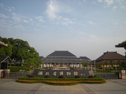 Hubei Provincial Museum · 湖北省博物馆
Hubei Provincial Museum湖北省博物馆
Hubei Provincial Museum is a strong introduction to the ancient states of Chu and Zeng. The bronze bells from the tomb of Marquis Yi and the Sword of Goujian make two very different kinds of metalwork tangible: musical precision…
Read the place guide → AI illustration; an interpretive view, not a photograph. AI 示意图,非景点实拍。
East Lake (Wuhan)武汉东湖
East Lake is a network of water, wooded hills and shoreline parks within Wuhan. Tingtao offers a lower-key lakeside setting and a connection with the poet Qu Yuan; Moshan brings hill views and a different sequence of gardens…
Read the place guide →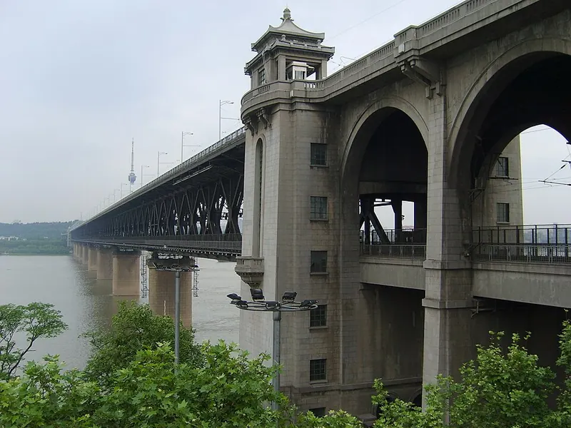 Wuhan Yangtze River Bridge · 武汉长江大桥 Photograph date recorded by the source: 2009-05-05 07:50.
Wuhan Yangtze River Bridge武汉长江大桥
Wuhan’s first Yangtze bridge is a working piece of transport history. Opened in 1957, it put road traffic above a double railway track and replaced the cumbersome ferrying of trains across the river. Its steel spans link Snake…
Read the place guide → Guiyuan Temple, Wuhan, Hubei.
Guiyuan Temple归元寺
Guiyuan Temple is an active Buddhist precinct in Hanyang whose best-known artistic feature is the hall of five hundred arhats. Their varied poses, expressions and gestures reward a slower look than a quick count. The principal…
Read the place guide → Entrance to Guqin Tai, the Lute Platform memorial in Wuhan, November 2019.
Guqin Tai古琴台
Guqin Tai commemorates the story of the musician Boya and Zhong Ziqi, the listener who understood his playing. Its setting between Turtle Hill and Moon Lake gives the musical tradition a quiet landscape context. The memorial has…
Read the place guide → Qingchuan Pavilion entrance gate, Wuhan · 武汉晴川阁入口 Photograph date recorded by the source: 11 May 2019, 14:36:29.
Qingchuan Pavilion晴川阁
Qingchuan Pavilion occupies a river-facing position on the Hanyang side of Wuhan. The visit joins three distinct elements: the pavilion itself, Yuji Palace and Tiemen Gate. Together they connect a river panorama with the memory…
Read the place guide →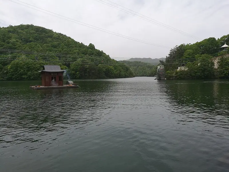 Huangpi Mulan Cultural and Ecological Tourism Area (黄陂木兰文化生态旅游区), Huangpi District. Photograph: "木兰天池 2024-04-24".
Huangpi Mulan Cultural and Ecological Tourism Area黄陂木兰文化生态旅游区
The Mulan tourism area in northern Wuhan groups four separate attractions: Mulan Mountain, Mulan Tianchi, Mulan Grassland and Mulan Yunwu Mountain.
Read the place guide →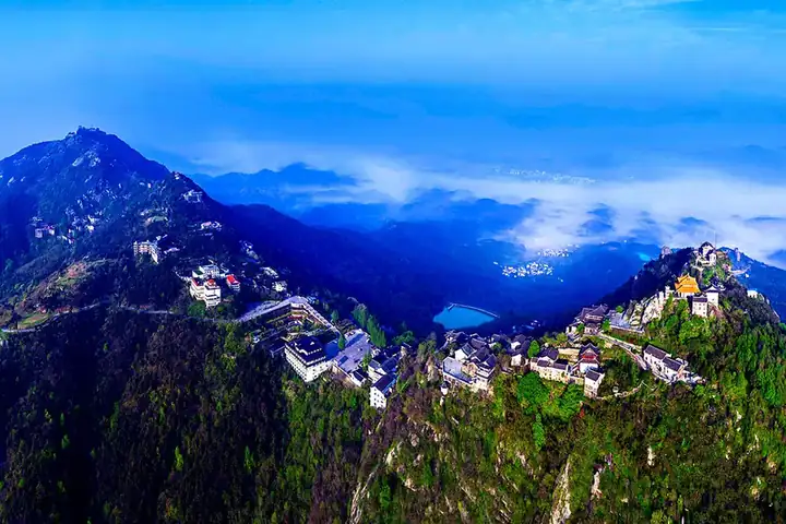 Mulan Mountain · 木兰山
Mulan Mountain木兰山
Mulan Mountain is the temple and mountain-walking destination within Huangpi's wider Mulan tourism area. Its religious buildings and local associations with the Mulan legend give it a different character from Mulan Tianchi or Mulan Grassland.
Read the place guide → The Grand Heaven Pool (大天池) at Mulan Tianchi scenic area in Huangpi District, Wuhan, with a floating pavilion · 武汉黄陂区木兰天池大天池景色,水上茶亭 Source-recorded photograph date: 2024-04-24 12:24:57.
Mulan Tianchi木兰天池
Mulan Tianchi is a forest and gorge destination in Huangpi's Changxuanling area. Waterfalls, stream pools and rock formations shape the walking experience, making it a distinct choice from the temples of Mulan Mountain.
Read the place guide → Entrance gate of Mulan Grassland scenic area, Huangpi District, Wuhan · 武汉黄陂区木兰草原景区大门 Source-recorded photograph date: Taken on 27 July 2013.
Mulan Grassland木兰草原
Mulan Grassland is a managed leisure attraction south of Mulan Mountain in Huangpi. It presents a grassland-themed setting with open lawns, activities and entertainment, rather than an expedition into the remote pastoral landscapes of northern China.
Read the place guide →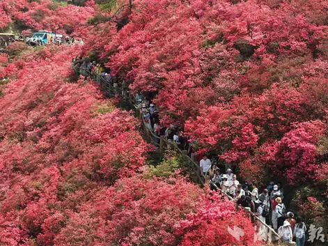 Mulan Yunwu Mountain · 木兰云雾山
Mulan Yunwu Mountain木兰云雾山
Mulan Yunwu Mountain is a Huangpi mountain destination known for spring azaleas and elevated views. Its different flower-viewing areas bloom in succession, so the name of the area matters as much as the general season.
Read the place guide →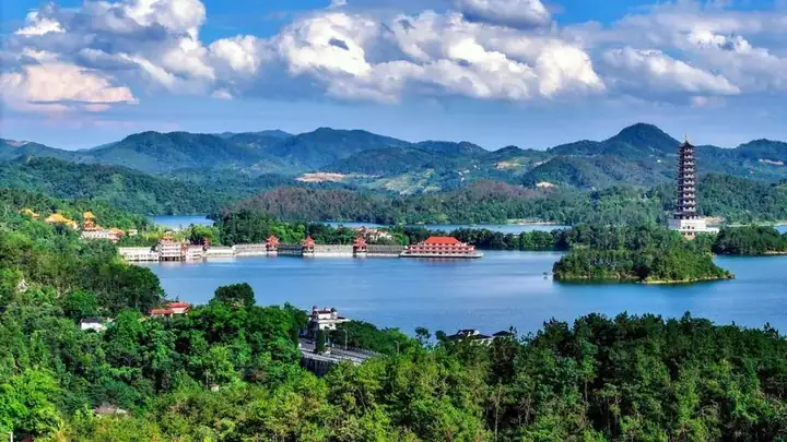 Daoguanhe Scenic Area · 道观河
Daoguanhe Scenic Area道观河
Scenic area of 72 hills and a 1956 reservoir in eastern Xinzhou, Wuhan, with Baoen Chan Temple and a reclining Buddha from Myanmar.
Read the place guide → A view across East Lake: a carved white stone balustrade with lotus-bud posts in the foreground, wide blue water behind it, a tree-lined far shore, and the high-rise skyline of Wuchang rising along the horizon under a clear blue sky.
East Lake东湖
East Lake (东湖) is a large freshwater lake inside the city of Wuhan, Hubei, at the centre of a scenic area that has been protected as one of China's first national key scenic and historic areas.
Read the place guide → 1911 Revolution Museum (辛亥革命博物院), Wuchang District. Photograph: "WuchangUprising".
1911 Revolution Museum辛亥革命博物院
The 1911 Revolution Museum (辛亥革命博物院) in Wuchang District, Wuhan, is the institution built around the Red Building at Yuemachang, the 1910 assembly hall where the Hubei Military Government of the Republic of China was formed the day after the Wuchang Uprising.
Read the place guide → Traditional brick buildings with red awnings along a street in the Tanhualin historic quarter, Wuchang District, Wuhan · 武汉市武昌区昙华林历史文化街区的传统建筑街景 Source-recorded photograph date: 2021-10-10 16:48:50.
Tanhualin Historic District昙华林
Car-free street in old Wuchang, Wuhan, that took shape after 1371, with churches, mission buildings and houses from 1864 to 1937.
Read the place guide →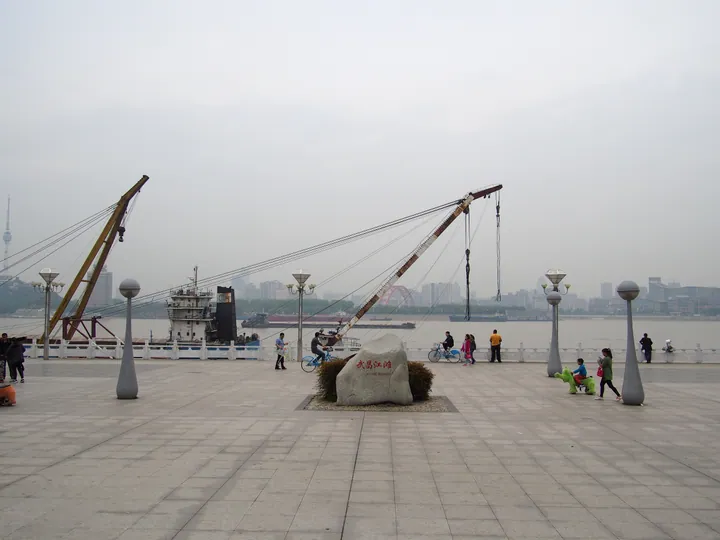 Waterfront plaza with a marker stone reading Wuchang Jiangtan and a view across the Yangtze River, Wuchang District, Wuhan · 武汉市武昌区武昌江滩,江边广场及长江对岸景观 Source-recorded photograph date: Taken on 9 April 2016.
Wuchang Riverside Park武昌江滩
Wuchang Riverside (武昌江滩) is the park along the right bank of the Yangtze in Wuchang District, Wuhan, part of the city's Hundred-li Yangtze Ecological Corridor and built on top of the river's flood defences.
Read the place guide → AI illustration · AI 示意图(仅供参考,非该地点实拍)
Wuhan University Campus武汉大学校园
The Wuhan University campus (武汉大学校园) occupies Luojia Hill and the hills around it beside East Lake in Wuchang District, Wuhan, and contains a group of buildings from China's modern era protected as a national key cultural heritage site.
Read the place guide → A broad view along the Yangtze at Hankou: a paved riverside promenade with stone paving and dark lamp columns at the right, a sandy beach strip where people stand at the water's edge, kite-flyers and strollers spread across the walk, a pier with pavilions mid-river, and the Hankou tower skyline across the water under an overcast sky.
Hankou Riverside Park汉口江滩
Hankou Riverside (汉口江滩) is the park along the left bank of the Yangtze in Wuhan, running about seven kilometres beside Yanjiang Avenue, built as flood defence on a sediment flat laid down by the river itself.
Read the place guide →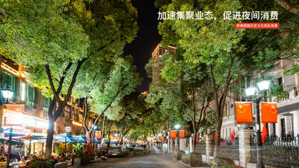 Lihuangpi Road Historic District · 黎黄陂路历史街区
Lihuangpi Road Historic District黎黄陂路历史街区
Lihuangpi Road (黎黄陂路) is a 604-metre street in the former Hankou Russian Concession of Jiang'an District, Wuhan, laid out in 1900 and now managed as a historic and cultural street lined with concession-era buildings.
Read the place guide → The Western-influenced facade of Gu De Si (Gude Temple) in Jiang'an District, Wuhan · 武汉市江岸区古德寺融合西式风格的殿宇立面 Source-recorded photograph date: 2023-04-08.
Gude Temple古德寺
Hankou Buddhist temple founded in 1877 that tended 1911 revolutionaries, known for its 1920s main hall modelled on Myanmar's Ananda Temple.
Read the place guide → Jianghan Road pedestrian shopping street in Hankou, Wuhan · 武汉汉口江汉路步行街 Source-recorded photograph date: 2008-09-10.
Jianghan Road Pedestrian Street江汉路步行街
Hankou's car-free shopping street, named in 1927 after the Jianghan Customs House at its river end, lined with early 20th-century banks and stores.
Read the place guide → The Yifu Museum building at the China University of Geosciences, Hongshan District, Wuhan · 中国地质大学逸夫博物馆外景,洪山区 Source-recorded photograph date: 2008-08-30.
China University of Geosciences Yifu Museum中国地质大学逸夫博物馆
University geology museum in Wuhan with dinosaur skeletons, gems, minerals and a campus fossil forest, housed in a 2003 building by East Lake.
Read the place guide →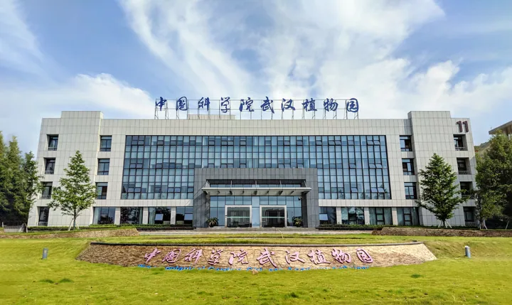 The administrative building of the Guanggu campus, Wuhan Botanical Garden · 中国科学院武汉植物园光谷园区办公楼 Source-recorded photograph date: 2018-07-17 08:33:43.
Wuhan Botanical Garden of the Chinese Academy of Sciences中国科学院武汉植物园
Chinese Academy of Sciences garden by East Lake with 17 specialty gardens, a national kiwifruit collection, aquatic plants and Three Gorges flora.
Read the place guide →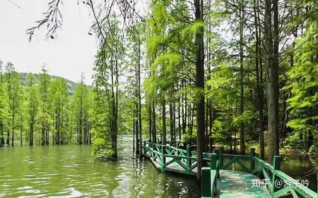 Jiuzhen Mountain · 九真山
Jiuzhen Mountain九真山
Jiuzhen Mountain (九真山) is a forested hill at Lufang Village in Caidian District, western Wuhan, whose 276-metre main peak is styled the 'first peak of the Jianghan Plain'; it is one of the district's two national forest parks and holds a 4A scenic area.
Read the place guide → Dayuwan Village · 大余湾
Dayuwan Village大余湾
Dayuwan (大余湾) is an ancient village in Shuangquan Village, Mulan Township, in Huangpi District north of Wuhan, founded in 1369 and now protected as a Chinese Historic and Cultural Village while operating as a 4A scenic area.
Read the place guide →Local life & food
Wuhan local specialties
武汉市特色美食 · 19 specialties to discover
 Fried flatbread with sticky-rice dumplings 油饼包烧梅AI illustration · AI 示意图
The combination layers crisp bread, soft wrappers and dense sticky rice, making it richer and more filling than its size suggests.
Source ↗Read the dish guide →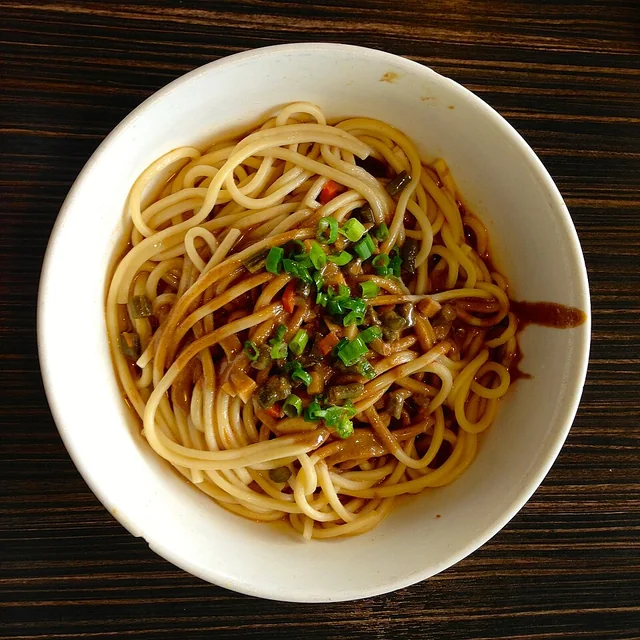 Hot dry noodles 热干面
The noodles are firm and springy, with a thick nutty coating. Mixing promptly matters because the sesame sauce can gather into dense patches as it cools.
Source ↗Read the dish guide →
Photo adjustments
EXIF orientation applied where present; resized proportionally to at most 640 px on the long edge and encoded as WebP. No crop, retouching, recoloring or subject changes.
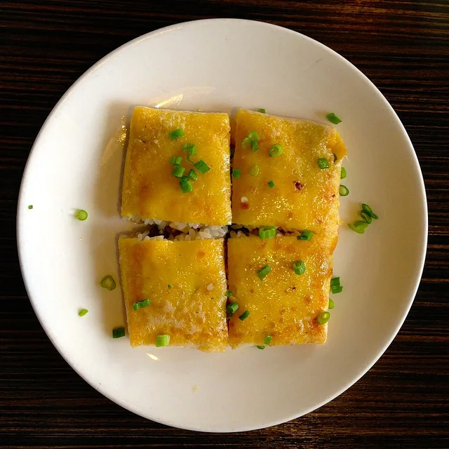 Three-delicacy doupi 三鲜豆皮
A crisp, lightly eggy surface contrasts with dense, chewy rice and juicy diced filling. The portion is more substantial than its thin exterior suggests.
Source ↗Read the dish guide →
Photo adjustments
EXIF orientation applied where present; resized proportionally to at most 640 px on the long edge and encoded as WebP. No crop, retouching, recoloring or subject changes.
 Wuchang fish 武昌鱼
The flesh is delicate and mild, with skin and fine bones shaping the eating experience. A braised version will have a fuller sauce.
Source ↗Read the dish guide →
Photo adjustments
EXIF orientation applied where present; resized proportionally to at most 640 px on the long edge and encoded as WebP. No crop, retouching, recoloring or subject changes.
 Wuhan peppery thick rice-noodle soup 糊汤米粉AI illustration · AI 示意图
The soup is smooth and coating, with prominent pepper warmth; thin noodles and a dipped fried-dough stick supply contrasting soft and crisp textures.
Source ↗Read the dish guide → Huangpi bean-and-rice noodles 黄陂豆丝AI dish illustration / AI 菜品示意图
The strips are soft but resilient and take up broth well. They differ from both wheat noodles and pressed soybean tofu sheets.
Source ↗Read the dish guide → Wuhan savoury rice-batter rings 武汉面窝AI dish illustration / AI 菜品示意图
The rim is softer inside, while the thinner parts break with a delicate crunch. Ginger and scallion give a savoury aroma; sweetness should not be expected just because the shape resembles a doughnut.
Source ↗Read the dish guide → Wuhan sesame-coated rice balls 欢喜坨AI dish illustration / AI 菜品示意图
Expect toasted sesame first, followed by sweet, sticky rice dough. The texture changes as the balls cool: the shell softens and the dough becomes firmer and chewier, which makes a freshly cooked serving distinctive.
Source ↗Read the dish guide →All dish names · 全部菜名 (19)
- Fried flatbread with sticky-rice dumplings · 油饼包烧梅
- Hot dry noodles · 热干面
- Three-delicacy doupi · 三鲜豆皮
- Wuchang fish · 武昌鱼
- Wuhan peppery thick rice-noodle soup · 糊汤米粉
- Huangpi bean-and-rice noodles · 黄陂豆丝
- Wuhan savoury rice-batter rings · 武汉面窝
- Wuhan sesame-coated rice balls · 欢喜坨
- Rice Noodles in Thickened Broth · 糊汤粉
- Beef Rice Noodles · 牛肉粉
- Spiced Braised Duck Necks · 鸭脖
- Pork-rib and lotus-root soup · 排骨藕汤
- Wuhan Fried Glutinous Rice Ball · 糯米鸡
- Soup-Filled Steamed Buns · 汤包
- Pounded Glutinous Rice Cakes · 糍粑
- Bean-and-Rice Noodle Strips · 豆丝
- Thickened Fermented Rice Drink · 糊米酒
- Shaomai Steamed Dumplings · 烧麦
- Sticky Rice Wrapped Fried Dough Stick · 糯米包油条
More dishes from across Hubei are in the Hubei food guide.
Counties & districts in Wuhan
13 areas belong directly to Wuhan.
13 areas
Jiang'an District江岸区
Jiang'an District forms part of the urban core of and is one of 13 urban districts of the prefecture-level city of Wuhan, the capital of Hubei Province, China.
Explore the area →DistrictJianghan District江汉区
Jianghan District forms part of the urban core of and is one of 13 urban districts of the prefecture-level city of Wuhan, the capital of Hubei Province, China. The district is part of the historical Hankou.
Explore the area →DistrictQiaokou District硚口区
Qiaokou District is one of 13 urban districts of the prefecture-level city of Wuhan, the capital of Hubei Province, China. It is situated on the northern (left) bank of the Han River.
Explore the area →DistrictHanyang District汉阳区
Hanyang District is one of 13 urban districts of the prefecture-level city of Wuhan, the capital of Hubei Province, China.
Explore the area →Show fewer areas
Wuchang District武昌区
Wuchang is one of 13 urban districts of the prefecture-level city of Wuhan, the capital of Hubei Province, China. It is the oldest of the three cities that merged into modern-day Wuhan, and stood on the right…
Explore the area →DistrictQingshan District青山区
Qingshan District is one of 13 urban districts of the prefecture-level city of Wuhan, the capital of Hubei Province, China.
Explore the area →DistrictHongshan District洪山区
Hongshan District is one of 13 urban districts of the prefecture-level city of Wuhan, the capital of Hubei Province, China. The district is named for Mount Hong, located near East Lake.
Explore the area →DistrictDongxihu District东西湖区
Dongxihu District is one of 13 urban districts of the prefecture-level city of Wuhan, the capital of Hubei Province, China, forming part of the city's western suburbs.
Explore the area →DistrictHannan District汉南区
Hannan District is one of 13 urban districts of the prefecture-level city of Wuhan, the capital of Hubei Province, China.
Explore the area →DistrictCaidian District蔡甸区
Caidian District is one of 13 urban districts that constitute the prefecture-level city of Wuhan, the capital of Hubei Province, China, forming part of the city's southwestern suburbs and situated on the…
Explore the area →DistrictJiangxia District江夏区
Jiangxia District is one of 13 urban districts of the prefecture-level city of Wuhan, the capital of Hubei province, China, situated on the eastern (right) bank of the Yangtze River.
Explore the area →DistrictHuangpi District黄陂区
Huangpi District is one of 13 urban districts of the prefecture-level city of Wuhan, the capital of Hubei Province, China, situated on the northern (left) bank of the Yangtze River.
Explore the area →DistrictXinzhou District新洲区
Xinzhou is one of 13 urban districts of the prefecture-level city of Wuhan, the capital of Hubei Province, China, covering part of the city's northeastern suburbs and situated on the northern (left) bank of…
Explore the area →No areas match this name.
Plan your visit
Getting there
Search for 武汉市 in a map app to find stations and your accommodation.
Where to stay →Build your route
Wuhan and Yellow Crane Tower are about 5 km apart in a straight line. The linked place guides have entrance and visit details.
Continue with Hubei →More in Hubei
Sources & geographic information
Administrative names and parent areas: Official geographic directory · Reference date 2026-09-06.
Some facts checked against 湖北省博物馆 — Wikipedia contributors, CC BY-SA 4.0.
Some facts checked against 热干面 — Wikipedia contributors, CC BY-SA 4.0.
Some facts checked against 武汉市 — Wikipedia contributors, CC BY-SA 4.0.
Photo: Wuhan · Zheng Zhou · CC BY-SA 4.0. Full frame retained; proportionally resized and converted to WebP. No retouching or changes to the photographed subject. Card displays may crop the view.

Photo: Yellow Crane Tower · MonsieurRoi · CC BY-SA 3.0. Wikimedia thumbnail; fitted to the ranking-card frame.

Photo: Hubei Provincial Museum · No machine-readable author provided. 风之清扬 assumed (based on copyright claims). · CC BY-SA 3.0. Wikimedia thumbnail; fitted to the ranking-card frame.

Photo: Wuhan Yangtze River Bridge · Fllee · CC BY-SA 3.0. Full frame retained; proportionally resized and converted to WebP. No retouching or changes to the photographed subject. Card displays may crop the view.

Photo: Guiyuan Temple · Gisling · CC BY 3.0. Proportionally resized and converted to WebP without cropping, retouching or changing the photographed subject.

Photo: Guqin Tai · kiraclyne · CC BY-SA 4.0. Proportionally resized and converted to WebP without cropping, retouching or changing the photographed subject.

Photo: Qingchuan Pavilion · Sherbet · Sherbet — Qingchuan Pavilion, Hubei, China.jpg — CC BY 2.5 · CC BY 2.5. The exact downloaded source bytes are separately retained and hashed. Prepared JPEG is proportionally reduced to a maximum 720-pixel long edge; full frame retained, no subject alteration. Final website rendition: full frame retained, proportionally resized to at most 720 pixels and converted to WebP. No additional retouching or subject alteration. Card displays may crop the view.

Photo: Huangpi Mulan Cultural and Ecological Tourism Area · Wang31 · CC BY 4.0. Full frame retained; EXIF orientation normalized, proportionally resized to at most 800 pixels and converted to WebP. No generated pixels or subject changes. Cards may crop the display.

Photo: Mulan Mountain · Source photographer · License not provided. EXIF orientation normalized; resized without changing aspect ratio; converted to WebP. No subject edits.
Photo: Mulan Tianchi · Wang31 · CC BY 4.0. Full frame retained; proportionally resized and converted to WebP. No retouching or changes to the photographed subject. Card displays may crop the view.

Photo: Mulan Grassland · fllee · CC BY-SA 3.0. Full frame retained; proportionally resized and converted to WebP. No retouching or changes to the photographed subject. Card displays may crop the view.

Photo: Mulan Yunwu Mountain · Source photographer · License not provided. EXIF orientation normalized; resized without changing aspect ratio; converted to WebP. No subject edits.
Photo: Daoguanhe Scenic Area · Source photographer · License not provided. EXIF orientation normalized; resized without changing aspect ratio; converted to WebP. No subject edits.
Photo: East Lake · fllee · CC BY-SA 3.0. Full frame retained; proportionally resized and converted to WebP. No retouching or changes to the photographed subject. Card displays may crop the view.

Photo: 1911 Revolution Museum · Mongol · CC BY-SA 3.0. Full frame retained; EXIF orientation normalized, proportionally resized to at most 800 pixels and converted to WebP. No generated pixels or subject changes. Cards may crop the display.

Photo: Tanhualin Historic District · Augustokremo · CC BY-SA 4.0. Full frame retained; proportionally resized and converted to WebP. No retouching or changes to the photographed subject. Card displays may crop the view.

Photo: Wuchang Riverside Park · Chen Huang · CC BY 3.0. Full frame retained; proportionally resized and converted to WebP. No retouching or changes to the photographed subject. Card displays may crop the view.

Photo: Hankou Riverside Park · Chen Huang · CC BY 3.0. Full frame retained; proportionally resized and converted to WebP. No retouching or changes to the photographed subject. Card displays may crop the view.

Photo: Lihuangpi Road Historic District · Source photographer · License not provided. EXIF orientation normalized; resized without changing aspect ratio; converted to WebP. No subject edits.
Photo: Gude Temple · ScareCriterion12 · CC0. Full frame retained; proportionally resized and converted to WebP. No retouching or changes to the photographed subject. Card displays may crop the view.
.jpg)
Photo: Jianghan Road Pedestrian Street · User:Vmenkov · CC BY-SA 3.0. Full frame retained; proportionally resized and converted to WebP. No retouching or changes to the photographed subject. Card displays may crop the view.

Photo: China University of Geosciences Yifu Museum · User:Vmenkov · CC BY-SA 3.0. Full frame retained; proportionally resized and converted to WebP. No retouching or changes to the photographed subject. Card displays may crop the view.

Photo: Wuhan Botanical Garden of the Chinese Academy of Sciences · Sun Jiao (Interaccoonale) · CC BY-SA 4.0. Full frame retained; proportionally resized and converted to WebP. No retouching or changes to the photographed subject. Card displays may crop the view.

Photo: Jiuzhen Mountain · Source photographer · License not provided. EXIF orientation normalized; resized without changing aspect ratio; converted to WebP. No subject edits.
Photo: Dayuwan Village · Source photographer · License not provided. EXIF orientation normalized; resized without changing aspect ratio; converted to WebP. No subject edits.
Map data © OpenStreetMap contributors. Pins mark approximate centres, not entrances or boundaries.