


Get to know Jian'ou
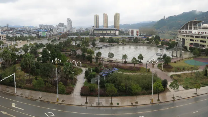
Photo adjustments
Full frame retained; proportionally resized and converted to WebP. No retouching or changes to the photographed subject. Card displays may crop the view.
- Administrative area
- County-level city · 县级市
- Part of
- Nanping
- Chinese name
- 建瓯市
- Local areas
- County-level city guide
Area & population
- Area in the source
- 4,199.00 km²
- Population · 2020
- 434,451
Source: cited geographic source, as of the dates shown.
Setting and landscape
Mountains ring the city on all sides, and its central part is mostly hills with basins and valleys between them. The Nanpu (南浦溪) and Chongyang (崇阳溪) streams meet in Xudun town (徐墩镇) to form the Jianxi (建溪), the city's largest river and a main tributary of the Min. The Jianxi runs south past Zhicheng (芝城镇), where the Songxi (松溪) joins it, and carries about a third of the Min's flow. The highest point is Chenshan (辰山) in Shuiyuan township (水源乡), 1,822.2 metres high and a city nature reserve.
History
Jian'an County (建安县) was created after Sun Ce (孙策), governor of Kuaiji, attacked the region in 196, and was among the first four counties formally established in what is now Fujian. In 733 the provincial name Fujian was formed from the first characters of Fuzhou and Jianzhou, whose seat was here. Wang Yanzheng (王延政), son of the Min ruler Wang Shenzhi (王审知) and prefect of Jianzhou, proclaimed himself emperor here in 943 under the name Yin, reverting to Min in 945. The area became Jianning Prefecture (建宁府) in 1162; in 1913 its two counties, Jian'an and Ouning (瓯宁), were merged as Jian'ou County, which became a city in 1992.
What to see
The Dongyue Temple (建瓯东岳庙), outside the old east gate in Jian'an subdistrict, was rebuilt in 1672 and has been a national protected site since 2006. It faces south onto the Jianxi with Baihe Hill (白鹤山) behind, and includes an opera stage and several halls. Provincial-level listed sites include the Confucian temple of the former Jianning Prefecture, the Tongxian Gate (通仙门) and the Beiyuan rock inscription (北苑凿字岩石刻).
Food and local products
Local foods include Jian'ou pressed duck (建瓯板鸭), guangbing (光饼) buns, taro dumplings (芋饺) and dingbianguo (鼎边粿). The land produces Beiyuan tea (北苑御茶), oolong tea and Jian'ou cone chestnuts (建瓯锥栗), a Chinese geographical-indication product, along with extensive moso bamboo forests. Jian'ou's tiaofan (挑幡, "banner raising") and gongyu (弓鱼, literally "bow fish") are both on the national intangible cultural heritage list.
Getting oriented
Jian'ou borders Jianyang (建阳区) to the north and Shunchang County (顺昌县) to the west. The Hefei–Fuzhou high-speed railway, opened in 2015, stops at Jian'ou West station, and the Quzhou–Ningde railway has Jian'ou East station in Shuiyuan township. The G3 Beijing–Taipei and G25 Changchun–Shenzhen expressways also cross the city.
Highlights
- Jian'ou Dongyue Temple 建瓯东岳庙: Rebuilt in 1672 on the Jianxi; national protected site since 2006.
- Chenshan 辰山: The city's highest peak at 1,822.2 metres, a city nature reserve in Shuiyuan township.
- Jian'ou cone chestnut 建瓯锥栗: A Chinese geographical-indication product.
- Tiaofan 挑幡: Jian'ou banner-raising custom on the national intangible heritage list.
Sources for this guide
自然资源 (建瓯市自然环境) · Jian'ou Municipal People's Government
地理环境 (建瓯市交通环境) · Jian'ou Municipal People's Government
建瓯市 - 维基百科,自由的百科全书 · Wikipedia (Chinese) · CC BY-SA 4.0
建瓯东岳庙 - 维基百科,自由的百科全书 · Wikipedia (Chinese) · CC BY-SA 4.0
Original English written from the listed sources and checked sentence by sentence against quoted extracts by a separate reviewer. Updated 2026-09-23.
Explore Jian'ou
Core places to explore, with English and Chinese names.
Plan your visit
Getting there
Jian'ou is about 45 km in a straight line from central Nanping. Search for 建瓯市 in a map app to find stations and your accommodation.
Where to stay →More in Nanping
Sources & geographic information
Administrative names and parent areas: Official geographic directory · Reference date 2026-09-06.
Some facts checked against 建瓯市 — Wikipedia contributors, CC BY-SA 4.0.
Some facts checked against 建瓯东岳庙 — Wikipedia contributors, CC BY-SA 4.0.
Map data © OpenStreetMap contributors. Pins mark approximate centres, not entrances or boundaries.