


Get to know Huai'an County
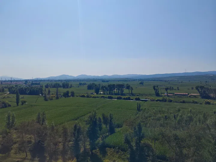
Photo adjustments
Full frame retained; proportionally resized and converted to WebP. No retouching or changes to the photographed subject. Card displays may crop the view.
- Administrative area
- County · 县
- Part of
- Zhangjiakou
- Chinese name
- 怀安县
- Local areas
- County guide
Area & population
- Area in the source
- 1,705.00 km²
- Population · 2020 census
- 179,949
Source: cited geographic source, as of the dates shown.
Setting and landscape
The county has long been known by the saying that a rooster's crow here is heard in three provinces. The climate is continental and monsoonal, with an average temperature of about 8°C and around 380 millimetres of rain a year, and the county government promotes its cool summers. Wooded areas include the Xiong'er Mountain (熊耳山) provincial forest park and the Lingguanmiao (灵官庙) and Jinshatan (金沙滩) forest farms; the county government also points to the old pines at Huwo Temple (虎卧寺).
History
In 110 BC the Han set up Yiyu County (夷舆县) at what is now Jiuhuai'an village (旧怀安村), and in the Northern Wei a wall 36 kilometres long was built across the county between Dongyanghe (东洋河) and Nanyanjie (南堰截) villages. The name Huai'an dates from 822, when the Tang took it from a Confucian phrase about people cherishing benevolent rule and living in peace. Under the Ming, Huai'an was a frontier garrison: the walled town of Huai'an (怀安城) was finished in 1393 and the Huai'an Guard moved into it, and in 1693 the Qing turned the guard into a county. The county seat moved from Huai'an town to Chaigoubu (柴沟堡) in 1951, and the county joined Hebei in 1952. Huai'an is also promoted as a national "home of Go" for its widespread Go culture.
Food and local products
Three foods are known together as the "three treasures of Huai'an". Chaigoubu smoked meat (柴沟堡熏肉), recognised by the Ministry of Commerce as a "China Time-Honoured Brand" product, is boned pork stewed, simmered and then smoked until the skin turns reddish and chewy; lamb, chicken and rabbit are smoked too. Huai'an town tofu skin (怀安城豆腐皮) is paper-thin and is used in cold and hot dishes; local tradition dates it to the Ming. Mashikou (马市口) "yiwosi" (一窝丝, "a nest of threads") is a flatbread rolled from one long hand-pulled strand and cooked in a pan with sesame oil; when one end of the strand is lifted and let go, it springs back into a coil. It comes from a village on the Ming road to Mongolia, where Datong prefecture once held a horse market.
Getting oriented
The Zhangjiakou–Hohhot and Zhangjiakou–Datong high-speed railways cross the county with a stop at Huai'an Station, and the Beijing–Baotou railway stops at Chaigoubu. The Beijing–Tibet and Beijing–Xinjiang expressways also run through the county.
Highlights
- Chaigoubu smoked meat 柴沟堡熏肉: Boned pork stewed and smoked to a reddish, chewy skin; a Ministry of Commerce "China Time-Honoured Brand" product.
- Huai'an town tofu skin 怀安城豆腐皮: Paper-thin tofu skin used in cold and hot dishes, dated by local tradition to the Ming.
- Mashikou yiwosi flatbread 马市口一窝丝饼: A single hand-pulled strand rolled into a flatbread and pan-cooked in sesame oil.
- Xiong'er Mountain Forest Park 熊耳山省级森林公园: Provincial forest park in the county.
Sources for this guide
怀安概况 · Huai'an County People's Government, Zhangjiakou
怀安之历史建制渊源 · Huai'an County People's Government, Zhangjiakou
怀安地理环境 · Huai'an County People's Government, Zhangjiakou
柴沟堡熏肉 · Huai'an County People's Government, Zhangjiakou
怀安城豆腐皮 · Huai'an County People's Government, Zhangjiakou
一窝丝饼 · Huai'an County People's Government, Zhangjiakou
Original English written from the listed sources and checked sentence by sentence against quoted extracts by a separate reviewer. Updated 2026-09-24.
Explore Huai'an County
Core places to explore, with English and Chinese names.
Huai'an County 怀安县
Plan your visit
Getting there
Huai'an County is about 45 km in a straight line from central Zhangjiakou. Search for 怀安县 in a map app to find stations and your accommodation.
Where to stay →More in Zhangjiakou
Sources & geographic information
Administrative names and parent areas: Official geographic directory · Reference date 2026-09-06.
Map data © OpenStreetMap contributors. Pins mark approximate centres, not entrances or boundaries.