


Get to know Xiahuayuan District
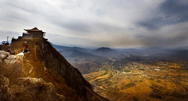
Photo adjustments
Full frame retained; proportionally resized and converted to WebP. No retouching or changes to the photographed subject. Card displays may crop the view.
- Administrative area
- District · 市辖区
- Part of
- Zhangjiakou
- Chinese name
- 下花园区
- Local areas
- District guide
Area & population
- Area in the source
- 315.40 km²
- Population · 2020 census
- 64,216
Source: cited geographic source, as of the dates shown.
Setting and landscape
Mountains, hills, river plain and floodland all occur in the district's 315 square kilometres. Three mountains stand over it: Jiming Mountain (鸡鸣山), Yudai Mountain (玉带山) and Yandong Mountain (燕洞山). The Daijiaying River (戴家营河), the Yang River (洋河) and the East River (东河) run side by side and join before flowing on into the Yongding River (永定河). The district government notes that the Yang is one of the few rivers in northern China that keeps flowing year-round, and that Shifo Mountain (石佛山) holds the best-preserved natural secondary forest in North China; the district has also built Hebei's first national-level fitness hiking trail.
History
The district is named after three imperial gardens, upper, middle and lower, that the Liao-dynasty Empress Dowager Xiao (萧太后) is said to have built here. In 1908 Xiahuayuan was the seat of a police substation of Xuanhua County, and Xiahuayuan town was founded in 1939. The district government describes it as a town "brought by the railway" and a former national supplier of coal and electricity; in 1990 three townships of Xuanhua County were added to it.
What to see
Jiming Mountain, 2 kilometres east of the district, is a solitary peak 1,128.9 metres high, nicknamed the "flying peak" (飞来峰) and promoted by the district as the "first wonder peak west of Beijing"; it is a national 4A-rated scenic area. It once held 112 temple halls, the earliest built in 231 BC, all destroyed in the Cultural Revolution; several sites have since been rebuilt. On the mountain are the Xiahuayuan Grottoes (下花园石窟), a Buddhist cave cut around 460 to 490 under the Northern Wei. It faces west on a horseshoe plan, with a weathered seated Shakyamuni almost 2 metres tall and a ceiling of eight flying apsaras around a large lotus; Hebei listed it as a provincial cultural relics protection site in October 2008.
Getting oriented
The district government places Xiahuayuan 60 kilometres southeast of central Zhangjiakou and 120 kilometres northwest of central Beijing. The Beijing–Baotou railway, National Highway 110 and provincial road 311 cross the district, and Xiahuayuan North station is a hub on the Beijing–Zhangjiakou high-speed railway.
Sources for this guide
下花园区情简介 · Xiahuayuan District People's Government, Zhangjiakou
花园史志 · Xiahuayuan District People's Government, Zhangjiakou
下花园区 · Wikipedia (Chinese) · CC BY-SA 4.0
鸡鸣山 (张家口) · Wikipedia (Chinese) · CC BY-SA 4.0
下花园石窟 · Wikipedia (Chinese) · CC BY-SA 4.0
Original English written from the listed sources and checked sentence by sentence against quoted extracts by a separate reviewer. Updated 2026-09-24.
Explore Xiahuayuan District
Core places to explore, with English and Chinese names.
Xiahuayuan District 下花园区
Plan your visit
Getting there
Xiahuayuan District is about 45 km in a straight line from central Zhangjiakou. Search for 下花园区 in a map app to find stations and your accommodation.
Where to stay →More in Zhangjiakou
Sources & geographic information
Administrative names and parent areas: Official geographic directory · Reference date 2026-09-06.
Some facts checked against 下花园区 — Wikipedia contributors, CC BY-SA 4.0.
Some facts checked against 鸡鸣山 (张家口) — Wikipedia contributors, CC BY-SA 4.0.
Some facts checked against 下花园石窟 — Wikipedia contributors, CC BY-SA 4.0.
Map data © OpenStreetMap contributors. Pins mark approximate centres, not entrances or boundaries.