


Get to know Zhangbei County
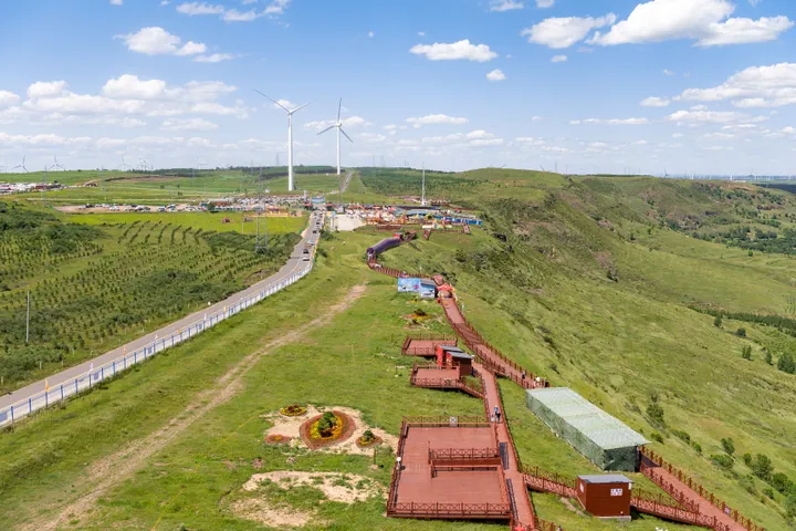
Photo adjustments
Full frame retained; proportionally resized and converted to WebP. No retouching or changes to the photographed subject. Card displays may crop the view.
- Administrative area
- County · 县
- Part of
- Zhangjiakou
- Chinese name
- 张北县
- Local areas
- County guide
Area & population
- Area in the source
- 4,185.00 km²
- Population · 2020 census
- 325,795
- Administrative seat
- Zhangbei Town
Source: cited geographic source, as of the dates shown.
Setting and landscape
The county covers 4,185 square kilometres, 109 kilometres from east to west and 70 from north to south. The frost-free period averages 107 days a year, and grass covers 72.5 per cent of the land, which the county government promotes as "home of the clouds, sea of grass". The county government says its clean power met the electricity needs of all 26 venues of the Beijing and Zhangjiakou Winter Olympic zones.
History
Great Walls of six periods, from the Yan, Zhao, Qin and Han to the Northern Wei and Ming, run through the county. The earliest recorded town was Huaihuang (怀荒镇), one of the Northern Wei's six frontier garrisons; an uprising there in 523 set off the Six Garrisons Rebellion. Under the Liao, Yanzi City (燕子城) here had a travelling palace for the emperors, and under the Yuan the area became Xinghe (兴和), where Kublai Khan chose the site of his first travelling palace. The Ming garrison withdrew to Xuanhua in the 1420s, and the county seat moved here from Zhangjiakou in 1918, when the name Zhangbei was adopted. The Zhangjiakou–Kulun road (张库大道), called a "northern Silk Road", crossed the county.
What to see
Yuan Zhongdu, 15 kilometres northwest of the county town, was begun in 1307 under Emperor Wuzong (Khaishan, 海山). It was named one of China's ten major archaeological discoveries of 1999, became a national key cultural relics protection site in 2001 and in 2017 was approved as Hebei's first national archaeological site park. Due south of the county town, beside National Highway 207, the Yehuling Fortress (野狐岭要塞) combines the main battlefield of the "802" military exercise, defence works completed in 1974 and the site of a battle between the Mongols and the Jin; it has military exhibits and tunnels. The Grassland Sky Road (草原天路) is one of the county's three tourism names.
Food and local products
Naked oats (莜麦) arrived with settlers after the 1902 decree opening the land to farming, and Bashang oat flour (莜面) is called the first of the "treasures beyond the pass"; oat-flour rolls (莜面窝窝) and little oat-flour fish (莜面鱼鱼) are Zhangbei specialities. Shanyao yu'er (山药鱼儿) are made from potato and oat flour, steamed in a basket and dipped in broth, mutton or wild-mushroom broth being preferred. The county government calls Zhangbei an important potato-seed base producing more than half of China's mini seed tubers.
Highlights
- Yuan Zhongdu National Archaeological Site Park 元中都国家考古遗址公园: Ruins of a Yuan capital begun in 1307; national key site since 2001.
- Yehuling Fortress 野狐岭要塞: Battlefield of the 802 military exercise and of a Mongol–Jin battle, with 1970s defence tunnels.
- Grassland Sky Road 草原天路: One of Zhangbei's three tourism names, with the Zhongdu grassland and the grassland music festival.
- Shanyao yu'er 山药鱼儿: Steamed potato and oat-flour pieces dipped in mutton or mushroom broth.
Sources for this guide
张北县情简介 · Zhangbei County People's Government, Zhangjiakou
张北资源 · Zhangbei County People's Government, Zhangjiakou
张北历史 · Zhangbei County People's Government, Zhangjiakou
元中都国家考古遗址公园 · Zhangbei County People's Government, Zhangjiakou
野狐岭要塞旅游区 · Zhangbei County People's Government, Zhangjiakou
张北山药鱼儿 · Zhangbei County People's Government, Zhangjiakou
坝上莜面 · Zhangbei County People's Government, Zhangjiakou
Original English written from the listed sources and checked sentence by sentence against quoted extracts by a separate reviewer. Updated 2026-09-24.
Explore Zhangbei County
Core places to explore, with English and Chinese names.
Zhangbei County 张北县
Plan your visit
Getting there
Zhangbei County is about 45 km in a straight line from central Zhangjiakou. Search for 张北县 in a map app to find stations and your accommodation.
Where to stay →More in Zhangjiakou
Sources & geographic information
Administrative names and parent areas: Official geographic directory · Reference date 2026-09-06.
Map data © OpenStreetMap contributors. Pins mark approximate centres, not entrances or boundaries.