


Get to know Qiaodong District
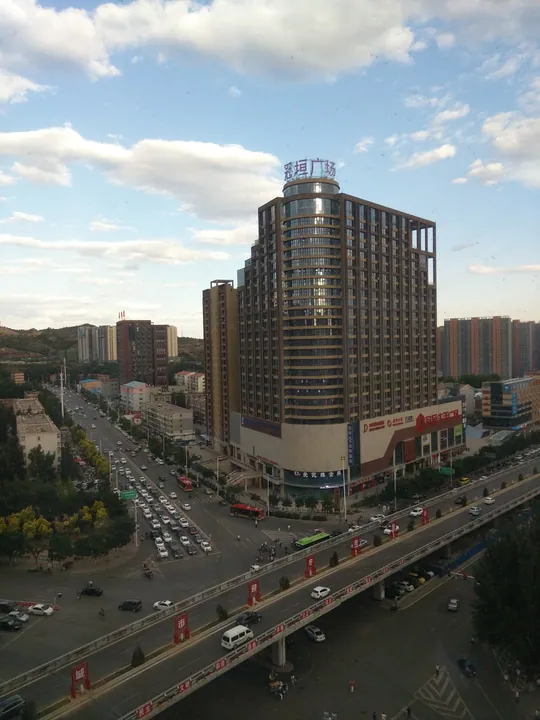
Photo adjustments
Full frame retained; proportionally resized and converted to WebP. No retouching or changes to the photographed subject. Card displays may crop the view.
- Administrative area
- District · 市辖区
- Part of
- Zhangjiakou
- Chinese name
- 桥东区
- Local areas
- District guide
Area & population
- Area in the source
- 403.20 km²
- Population · 2020 census
- 422,753
Source: cited geographic source, as of the dates shown.
History
The names Qiaodong and Qiaoxi (桥西, "west of the bridge") go back to 1601, when a Ming garrison commander and local people paid for a bridge over the Qingshui River southeast of Zhangjiakou Fort (张家口堡). When the Beijing–Zhangjiakou railway (京张铁路) was built in 1909, its station was sited in Qiaodong; trade moved down from the old upper fort to new markets around the station, and the district took shape around them. In 1955 the city's First District was renamed Qiaodong, with the Qingshui River as its boundary. In 2016 the State Council approved the abolition of Xuanhua County (宣化县) and the transfer of Dacanggai town (大仓盖镇) and Dongwangshan township (东望山乡) to the district.
What to see
The former headquarters of the Jin-Cha-Ji Military Region (晋察冀军区司令部旧址), at 62 Xuanhua Road on the grounds of Zhangjiakou No. 6 Middle School, is a European-style building whose plan resembles the character pin (品). The command was based here from August 1945 until October 1946, and the site became a major national protected site in 2013. The terminus of the Beijing–Zhangjiakou railway, Zhangjiakou North Station, and the site of North China United University (华北联大) are provincial protected sites.
Aiwulu (爱吾庐), at 45 Deshengxi Street, is a grey-brick Western-style house that General Feng Yuxiang (冯玉祥) bought after moving his northwest border defence office to Zhangjiakou in 1925; he used it as his library and to receive guests, and it became a provincial protected site in 2008. On the eastern hillside in the north of the district, the Chahar Martyrs' Cemetery (察哈尔烈士陵园) covers about 15.3 hectares; its halls list 6,703 names, including the war hero Dong Cunrui (董存瑞), and the district government describes it as the earliest-built and largest martyrs' cemetery in North China. Remains of the old Great Wall lie at Weiyuan Tower (威远台) in Dongyulin village, Qingbiankou (青边口) and Changyukou (常峪口).
Getting oriented
The Qingshui, Dongsha (东沙河), Wangjiazhai (王家寨河) and Panchang (盘长河) rivers cross the district. Its parks include the Industrial Culture Theme Park, a national 3A-rated scenic area that won a national landscape architecture gold award, along with Dongtaipingshan and Victory parks. The district has two expressway exits, at Wuyi Road and Weisan Road, linked to the Beijing–Tibet and Zhangjiakou–Shijiazhuang expressways, as well as Zhangjiakou Airport, and its eight shopping complexes include Yinzuo and Parkson.
Highlights
- Former Jin-Cha-Ji Military Region Headquarters 晋察冀军区司令部旧址: European-style building used as the regional command from 1945 to 1946; major national protected site since 2013.
- Aiwulu 爱吾庐: Feng Yuxiang's house and library after his 1925 move to Zhangjiakou; provincial protected site since 2008.
- Chahar Martyrs' Cemetery 察哈尔烈士陵园: Hillside cemetery listing 6,703 names, including Dong Cunrui.
- Industrial Culture Theme Park 工业文化主题公园: National 3A-rated park that won a national landscape architecture gold award.
Sources for this guide
张家口市桥东区概况 · Qiaodong District People's Government, Zhangjiakou
张家口市桥东区历史沿革 · Qiaodong District People's Government, Zhangjiakou
晋察冀军区司令部旧址 · Qiaodong District People's Government, Zhangjiakou
冯玉祥故居“爱吾庐” · Qiaodong District People's Government, Zhangjiakou
察哈尔烈士陵园 · Qiaodong District People's Government, Zhangjiakou
Original English written from the listed sources and checked sentence by sentence against quoted extracts by a separate reviewer. Updated 2026-09-24.
Explore Qiaodong District
Core places to explore, with English and Chinese names.
Qiaodong District 桥东区
Plan your visit
Getting there
Qiaodong District covers the centre of Zhangjiakou. Search for 桥东区 in a map app to find stations and your accommodation.
Where to stay →More in Zhangjiakou
Sources & geographic information
Administrative names and parent areas: Official geographic directory · Reference date 2026-09-06.
Map data © OpenStreetMap contributors. Pins mark approximate centres, not entrances or boundaries.