


Get to know Qiaoxi District
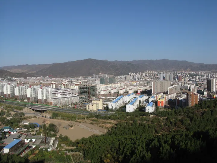
Photo adjustments
Full frame retained; proportionally resized and converted to WebP. No retouching or changes to the photographed subject. Card displays may crop the view.
- Administrative area
- District · 市辖区
- Part of
- Zhangjiakou
- Chinese name
- 桥西区
- Local areas
- District guide
Area & population
- Area in the source
- 210.19 km²
- Population · 2020 census
- 279,033
- Administrative seat
- Nanyingfang Subdistrict
Source: cited geographic source, as of the dates shown.
History
Zhangjiakou Fort (张家口堡), known locally as Baozili (堡子里), was founded in 1429 by Zhang Wen (张文), commander of the Wanquan Right Guard, as part of the Great Wall defences. From 1571 a tea-and-horse market between Mongols and Han traders was held outside the wall, and in 1613 a small gate was opened in the wall and Laiyuan Fort (来远堡) was built on its inner side. After Dajingmen opened under the Qing, the Zhangku road (张库大道) ran from here to Kulun, now Ulaanbaatar, and on into Russia, and the fort turned from a garrison into a trading town. In the 1920s and 1930s, according to a history of the trade cited in a report carried by China News Service, foreign merchants ran 44 trading houses and Chinese traders 42 banks and money shops here. The city of Zhangjiakou was set up on this area in the 1930s.
What to see
Dajingmen (大境门), the Great Wall gate in the north of the city, stands between Xitaiping Mountain (西太平山) and the Qingshui River. Built in 1644, its gate wall is 12 metres high, and above the arch are the characters "大好河山" ("a land of great rivers and mountains"), written in 1927 by the Chahar military governor Gao Weiyue (高维岳). It is traditionally counted with Shanhaiguan, Jiayuguan and Juyongguan as one of the four great passes of the Great Wall, and the only one called a gate.
Zhangjiakou Fort covers about 23 hectares, 590 metres east to west and 330 metres north to south. China News Service reported in 2012 that 20 lanes and 478 courtyards kept their original layout, including old government offices, temples, foreign trading houses and banks, and that restoration begun in 2009 had covered sites such as Wenchang Pavilion (文昌阁), Yuhuang Pavilion (玉皇阁), Luncai Academy (抡才书院) and the Kangxi Teahouse (康熙茶楼). Jinquanxing Lane (锦泉兴巷) was a street of banks, and the Qiao family of Qixian (祁县) in Shanxi ran the Hongmao bank (宏茂票号) in the fort's second lane.
Getting oriented
The Qingshui River enters the city just east of Dajingmen and runs south through it. The district government describes Qiaoxi as the city's centre for trade, tourism services, culture and education, and it is Zhangjiakou's central shopping area, with many large markets.
Highlights
- Dajingmen 大境门: Great Wall gate built in 1644, with a 1927 inscription by Gao Weiyue above the arch.
- Zhangjiakou Fort (Baozili) 张家口堡: Garrison fort founded in 1429 that became a trading and banking town on the Zhangku road.
- Laiyuan Fort 来远堡: Fort built on the inner side of the Great Wall in 1613, when a small gate was opened in the wall.
- Kangxi Teahouse 康熙茶楼: Restored two-storey former tea house on the fort's East Gate Street.
Sources for this guide
桥西概况 · Qiaoxi District People's Government, Zhangjiakou
五百岁古堡恢复原貌 张家口市由此演变而来 · China News Service (report from Liaoning Daily)
大境门 · Wikipedia (Chinese) · CC BY-SA 4.0
桥西区 (张家口市) · Wikipedia (Chinese) · CC BY-SA 4.0
清水河 (张家口市) · Wikipedia (Chinese) · CC BY-SA 4.0
Original English written from the listed sources and checked sentence by sentence against quoted extracts by a separate reviewer. Updated 2026-09-24.
Explore Qiaoxi District
Core places to explore, with English and Chinese names.
Places to explore around Qiaoxi District
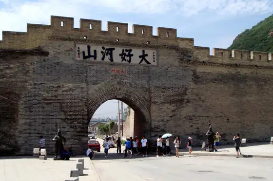 Dajingmen ·
 Plan your visit
Getting there
Qiaoxi District is about 8 km in a straight line from central Zhangjiakou. Search for 桥西区 in a map app to find stations and your accommodation.
Where to stay →Build your route
Start with Dajingmen. The linked place guides have entrance and visit details.
Continue with Zhangjiakou →More in Zhangjiakou
Sources & geographic information
Administrative names and parent areas: Official geographic directory · Reference date 2026-09-06.
Some facts checked against 大境门 — Wikipedia contributors, CC BY-SA 4.0.
Some facts checked against 桥西区 (张家口市) — Wikipedia contributors, CC BY-SA 4.0.
Some facts checked against 清水河 (张家口市) — Wikipedia contributors, CC BY-SA 4.0.
Photo: Dajingmen · Wangyunfeng · CC BY-SA 3.0. Resized and WebP compressed; subject not altered.

Map data © OpenStreetMap contributors. Pins mark approximate centres, not entrances or boundaries.