


Get to know Daoli District
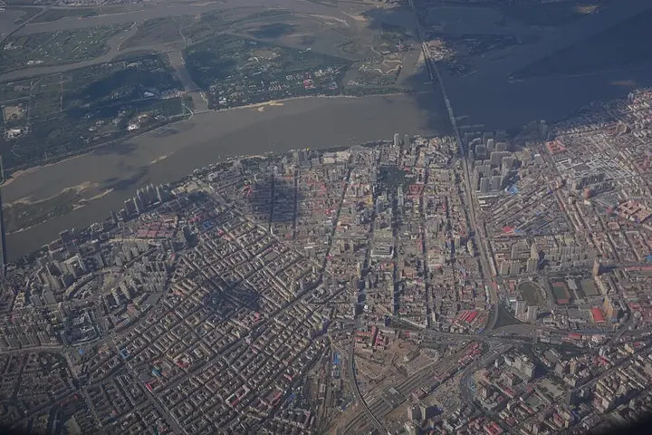
Photo adjustments
Full frame retained; proportionally resized and converted to WebP. No retouching or changes to the photographed subject. Card displays may crop the view.
- Administrative area
- District · 市辖区
- Part of
- Harbin
- Chinese name
- 道里区
- Local areas
- District guide
Area & population
- Area in the source
- 479.20 km²
- Population · 2020 census
- 1,097,430
- Administrative seat
- Fushun Subdistrict
Source: cited geographic source, as of the dates shown.
History
The district grew up with the Chinese Eastern Railway (中东铁路), built under a secret treaty between the Qing and Russia: land west of the tracks became Daoli and land to the east Daowai. The district was once called Pristan, the wharf district (埠头区), and a banking and shopping quarter formed around what was then China Street. In 1899 the first section of the railway, from Harbin to the Ashi River, opened from Songhua River station in Daoli.
What to see
Central Street runs 1,450 metres from Xinyang Square north to the Songhua embankment and is paved with square stone setts. Laid out in 1898 as China Street, it took its present name in July 1928 and opened as a pedestrian street on 1 June 1997. Harbin Daily reports 75 European and European-style buildings along it, 36 of them protected, in Art Nouveau, Baroque, classical, eclectic and Art Deco styles, and calls the street China's first open, public museum of architecture. In 2009 it was among the first ten streets named Famous Historical and Cultural Streets of China. Harbin Daily singles out the Art Nouveau former First-Class Post Office at the south end and the 1910 Churin (秋林) store building at the north end.
St Sophia Cathedral (圣索菲亚教堂), near Central Street in Zhaolin subdistrict, is described by Chinese Wikipedia as the largest Orthodox church in the Far East. The present red-brick church, designed by the Russian architect Mikhail Oskolkov, was begun in 1923 and finished in 1932. It was listed as a major national protected site in 1996 and now houses the Harbin architecture art museum rather than services.
At the north end of Central Street, the Flood Control Memorial Tower (防洪纪念塔) marks the city's defence against the 1957 Songhua flood. Finished in 1958 on the river embankment, it stands 22.5 metres high in Stalin Park (斯大林公园), faces Central Street and carries figures and reliefs of the flood fight; the 1998 flood level was later added to it.
Getting oriented
Harbin Station is the only station on the Beijing–Harbin railway inside the district, and Harbin Taiping International Airport lies in its southwest, linked to the city by the airport expressway. Metro Lines 2 and 3 have stations in Daoli.
Highlights
- Central Street 中央大街: 1,450-metre stone-paved street of 75 European-style buildings; named a Famous Historical and Cultural Street of China in 2009.
- St Sophia Cathedral 圣索菲亚教堂: Orthodox church completed in 1932, a national protected site since 1996, now an architecture museum.
- Flood Control Memorial Tower 防洪纪念塔: 22.5-metre tower of 1958 at the river end of Central Street, commemorating the 1957 flood.
Sources for this guide
道里区 - 维基百科,自由的百科全书 · Wikipedia (Chinese) · CC BY-SA 4.0
中央大街 - 维基百科,自由的百科全书 · Wikipedia (Chinese) · CC BY-SA 4.0
圣索菲亚教堂 - 维基百科,自由的百科全书 · Wikipedia (Chinese) · CC BY-SA 4.0
防洪纪念塔 - 维基百科,自由的百科全书 · Wikipedia (Chinese) · CC BY-SA 4.0
哈尔滨日报-建筑艺术博物馆界的“顶流” · Harbin Daily
Original English written from the listed sources and checked sentence by sentence against quoted extracts by a separate reviewer. Updated 2026-09-25.
Explore Daoli District
Core places to explore, with English and Chinese names.
Places to explore around Daoli District
 Zhongyang Pedestrian Street · 中央大街
Zhongyang Street中央大街
Zhongyang Street is an architectural walk as well as a shopping street. Its rounded stone paving runs toward the Songhua River through façades associated with Harbin's early international trading community. At No. 89, the Modern…
Read the place guide →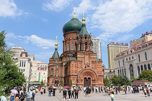 West facade of Saint Sophia Cathedral and the public square in Harbin · 哈尔滨圣索菲亚教堂西立面与广场. Source-recorded photograph date: 2023-07-21 15:04:50.
Saint Sophia Cathedral Square圣索菲亚教堂广场
St. Sofia Church Square centers on the red-brick Byzantine church in Daoli whose present building was constructed from 1923 to 1932.
Read the place guide → AI illustration · AI 示意图(仅供参考,非该地点实拍)
Songhua River Flood Control Memorial Tower松花江防洪纪念塔江畔
Harbin's Flood Control Memorial marks the meeting of Central Street and the Songhua riverfront, commemorating the city's response to the major flood of 1957.
Read the place guide →Plan your visit
Getting there
Daoli District covers the centre of Harbin. Search for 道里区 in a map app to find stations and your accommodation.
Where to stay →Build your route
Zhongyang Street and Saint Sophia Cathedral Square are both listed here. The linked place guides have entrance and visit details.
Continue with Harbin →More in Harbin
Sources & geographic information
Administrative names and parent areas: Official geographic directory · Reference date 2026-09-06.
Some facts checked against 道里区 — Wikipedia contributors, CC BY-SA 4.0.
Some facts checked against 中央大街 — Wikipedia contributors, CC BY-SA 4.0.
Some facts checked against 圣索菲亚教堂 — Wikipedia contributors, CC BY-SA 4.0.
Some facts checked against 防洪纪念塔 — Wikipedia contributors, CC BY-SA 4.0.
Photo: Zhongyang Street · N509FZ · CC BY-SA 4.0. Wikimedia thumbnail; fitted to the ranking-card frame.
.jpg)
Photo: Saint Sophia Cathedral Square · N509FZ · CC BY-SA 4.0. Full source framing retained; proportionally resized and converted to WebP. No retouching or subject alteration. Card displays may crop the view.
.jpg)
Map data © OpenStreetMap contributors. Pins mark approximate centres, not entrances or boundaries.