


Get to know Hongqi District
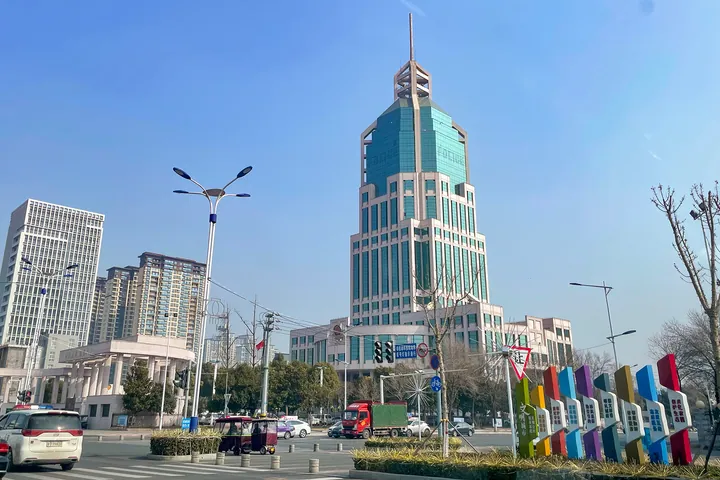
Photo adjustments
Full frame retained; proportionally resized and converted to WebP. No retouching or changes to the photographed subject. Card displays may crop the view.
- Administrative area
- District · 市辖区
- Part of
- Xinxiang
- Chinese name
- 红旗区
- Local areas
- District guide
Area & population
- Area in the source
- 99.00 km²
- Population · 2019
- 456,400
Source: cited geographic source, as of the dates shown.
Setting and landscape
Xinxiang, known in antiquity as Muye (牧野), lies on the north bank of the Yellow River, with the Taihang Mountains (太行山) to the north. Hongqi District covers 154.45 square kilometres, but two national development zones, the Xinxiang High-tech Industrial Development Zone and the Xinxiang Economic and Technological Development Zone, sit within it, and the area the district actually administers is about 77 square kilometres. It is made up of two towns and five urban subdistricts.
History
In August 1949 Xinxiang became the capital of Pingyuan Province (平原省), a short-lived province dissolved in November 1952, after which the city passed to Henan. The Xinxiang Museum grew out of the Pingyuan Provincial Museum, set up in 1949 under the province's cultural relics committee.
What to see
The Xinxiang Museum (新乡市博物馆) is housed in the Pingyuan Museum (平原博物院) at 697 Renmin East Road (人民东路), a complex completed in 2011 that it shares with the city archives and local chronicles office. It is a general museum of local history, known for Shang and Zhou bronzes, Ming and Qing painting and calligraphy, and rubbings of inscribed steles; its collection comes from the fifty-odd counties and cities of the former Pingyuan Province.
The district's one national heritage site is the Daguan Shengzuo Stele (大观圣作之碑) of the Xinxiang Confucian Temple (新乡文庙), a Northern Song inscribed stone. The temple itself, of Ming and Qing date, is on the Henan provincial list. So are Dongning Temple (东宁寺) and three sites in Dongjie subdistrict (东街街道): the Qing-dynasty Seven Generations Under One Roof Archway (七世同居坊), the Xinxiang Dongyue Temple (新乡东岳庙) and the Xinxiang Guandi Temple (新乡关帝庙), whose buildings date from the Yuan to the Qing.
Getting oriented
Five universities are based in the district: Henan University of Medical Sciences (河南医药大学), Henan Institute of Science and Technology (河南科技学院), Henan Institute of Technology (河南工学院), Xinxiang University (新乡学院) and Xinxiang Vocational and Technical College (新乡职业技术学院). Across Xinxiang, the Beijing–Guangzhou high-speed railway, the Zhengzhou–Jinan high-speed railway and several conventional lines meet.
Highlights
- Xinxiang Museum 新乡市博物馆: Local history museum in the Pingyuan Museum complex, completed in 2011; known for Shang and Zhou bronzes and stele rubbings.
- Daguan Shengzuo Stele 新乡文庙大观圣作之碑: Northern Song stele at the Xinxiang Confucian Temple; a national key heritage site.
- Seven Generations Under One Roof Archway 七世同居坊: Qing-dynasty archway in Dongjie subdistrict on the Henan provincial heritage list.
- Xinxiang Guandi Temple 新乡关帝庙: Provincially listed temple with buildings from the Yuan to the Qing.
Sources for this guide
红旗区简介_新乡市人民政府 · Xinxiang Municipal People's Government
新乡概况_新乡市人民政府 · Xinxiang Municipal People's Government
新乡市博物馆 - 维基百科,自由的百科全书 · Wikipedia (Chinese) · CC BY-SA 4.0
红旗区各级文物保护单位列表 - 维基百科,自由的百科全书 · Wikipedia (Chinese) · CC BY-SA 4.0
Original English written from the listed sources and checked sentence by sentence against quoted extracts by a separate reviewer. Updated 2026-09-24.
Explore Hongqi District
Core places to explore, with English and Chinese names.
Hongqi District 红旗区
Plan your visit
Getting there
Hongqi District covers the centre of Xinxiang. Search for 红旗区 in a map app to find stations and your accommodation.
Where to stay →More in Xinxiang
Sources & geographic information
Administrative names and parent areas: Official geographic directory · Reference date 2026-09-06.
Some facts checked against 新乡市博物馆 — Wikipedia contributors, CC BY-SA 4.0.
Some facts checked against 红旗区各级文物保护单位列表 — Wikipedia contributors, CC BY-SA 4.0.
Map data © OpenStreetMap contributors. Pins mark approximate centres, not entrances or boundaries.