


Get to know Yanjin County
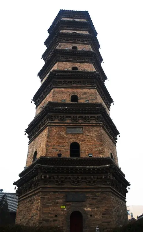
Photo adjustments
EXIF orientation normalized; resized without changing aspect ratio; converted to WebP. No subject edits.
- Administrative area
- County · 县
- Part of
- Xinxiang
- Chinese name
- 延津县
- Local areas
- County guide
Area & population
- Area in the source
- 886.00 km²
- Population · 2019
- 456,900
Source: cited geographic source, as of the dates shown.
History
The county government counts more than 3,000 years of recorded history. Under the Qin the area became Suanzao County (酸枣县), named for the thorny scrub that covered it, and in 1117, under the Song, it took the name Yanjin after a ferry crossing on the Yellow River.
Chen Yucheng (陈玉成), the Taiping general who held the title Heroic King (英王), was captured in 1862 and executed at Yanjin, at the age of 26, while being taken to Beijing. The county raised a memorial stone at the site in 1958, and it is now a Henan provincial protected site. Yanjin is also the home county of the novelist Liu Zhenyun (刘震云), winner of the Mao Dun Literature Prize whose works include 1942 and Yi Ju Ding Yi Wan Ju (一句顶一万句, "one sentence outweighs ten thousand").
What to see
Dajue Temple (大觉寺) in the county town was founded in the Tianbao era of the Tang (742–755) as Shangcheng Temple (上乘寺) and renamed after it was rebuilt in the Xuande era of the Ming. Its Wanshou Pagoda (万寿塔) is a six-sided, seven-storey brick pagoda 29.67 metres tall, rebuilt between 1549 and 1585, with stairs and passages inside that lead up floor by floor. The State Council listed it as a national protected site in October 2019. The temple's most valued stele carries a text written by the Yuan calligrapher Zhao Mengfu (赵孟頫), and the grounds now hold a museum. The Guangtang Temple Pagoda (广唐寺塔) and the Shamen walled-town site (沙门城址) are also national protected sites.
The Henan Yellow River Old Course Forest Park (河南黄河故道森林公园) grew out of the state-run Yanjin forest farm on the abandoned bed of the Yellow River, 20 kilometres due east of Xinxiang. The park holds a 10,000-mu grove of huai (槐) trees on rolling sand dunes, along with orchards and a botanical garden; it became an AAA scenic area in 2010.
Food and local products
Yanjin huoshao (延津火烧) is a round, domed flatbread, bigger than an ordinary sesame cake, copper-coloured and layered, and packed with meat; it is crisp outside and tender inside. Xinxiang listed it as municipal intangible heritage in 2013.
Wheat is grown on about a million mu in a normal year, and organic wheat from Yanjin goes into Moutai (茅台) liquor. Yanjin wheat, spinach, black beans and safflower, along with carrots from Xiaotan (小潭乡), carry national geographical-indication trademarks. The county is also known for peanuts, and a local fishery is Henan's only national breeding farm for Yellow River carp.
Highlights
- Wanshou Pagoda at Dajue Temple 大觉寺万寿塔: Six-sided, seven-storey Ming brick pagoda, 29.67 m, listed nationally in 2019.
- Henan Yellow River Old Course Forest Park 河南黄河故道森林公园: Huai tree forest on sand dunes of the old Yellow River bed; AAA scenic area since 2010.
- Yanjin huoshao 延津火烧: Meat-filled layered flatbread, Xinxiang municipal intangible heritage since 2013.
- Chen Yucheng memorial 陈玉成就义纪念地: Execution site of the Taiping Heroic King in 1862; provincial protected site.
Sources for this guide
延津概况 - 延津县人民政府 · Yanjin County People's Government
延津火烧 - 自然地理 - 延津县人民政府 · Yanjin County People's Government
陈玉成墓与陈玉成纪念馆 - 图说延津 - 延津县人民政府 · Yanjin County People's Government
大觉寺•万寿塔 - 图说延津 - 延津县人民政府 · Yanjin County People's Government
河南黄河故道森林公园 - 图说延津 - 延津县人民政府 · Yanjin County People's Government
Original English written from the listed sources and checked sentence by sentence against quoted extracts by a separate reviewer. Updated 2026-09-24.
Explore Yanjin County
Core places to explore, with English and Chinese names.
Yanjin County 延津县
Plan your visit
Getting there
Yanjin County is about 30 km in a straight line from central Xinxiang. Search for 延津县 in a map app to find stations and your accommodation.
Where to stay →More in Xinxiang
Sources & geographic information
Administrative names and parent areas: Official geographic directory · Reference date 2026-09-06.
Map data © OpenStreetMap contributors. Pins mark approximate centres, not entrances or boundaries.