


Get to know Shangjie District
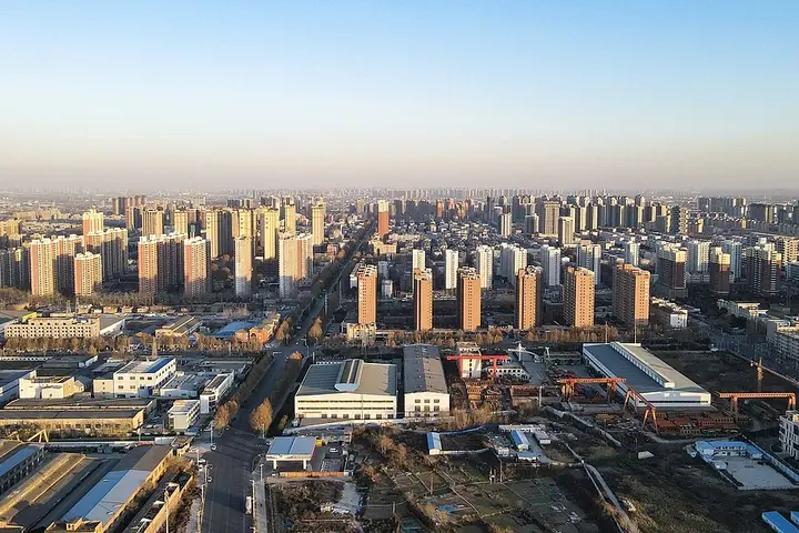
Photo adjustments
Full frame retained; proportionally resized and converted to WebP. No retouching or changes to the photographed subject. Card displays may crop the view.
- Administrative area
- District · 市辖区
- Part of
- Zhengzhou
- Chinese name
- 上街区
- Local areas
- District guide
Area & population
- Population · 2019
- 144,000
- Administrative seat
- Jiyuan Road Subdistrict (济源路街道)
Source: cited geographic source, as of the dates shown.
History
The district is named after Shangjie railway station, opened in 1956, which in turn took its name from Shangjie village (上街村), 2 kilometres northwest of the district. The 1928 revision of the Sishui county gazetteer (汜水县志) records the local tradition that Shangjie town stood on the site of the Zhou-era city of Eastern Guo (东虢). Local legend says the physician Bian Que (扁鹊) revived a dying Guo prince here, and the grateful prince built the Luyi Temple (卢医庙). Herb fairs held round the temple for half a month in the fourth and tenth lunar months grew into a herb market known across China, and it lasted beyond 1949. When floods drove the Sishui county seat uphill to the temple market during the reign of the Ming emperor Wuzong, people began calling it the "upper street", shangjie.
In November 1957 the Henan Aluminium Company (河南铝业公司), described by the district government as the country's largest aluminium base, was sited south of the station, and on 5 August 1958 Shangjie District was formally set up.
Setting and landscape
Shangjie sits on loess hill country where the plains of eastern Henan meet the western Henan hills. The west and south are broken upland, and most of the district lies on old terraces of the Yellow River, stepping down from wind-blown loess ridges in the south to alluvial plain in the north. The Si River (汜水河), a direct tributary of the Yellow River, crosses the district for 9.2 kilometres; the seasonal Ku River (枯河) rises at Nianlipu village (廿里铺村). Woodland is concentrated in the southern hills.
What to see
Three sites are protected at provincial level. The Chongyang Temple at Guangou (观沟重阳观) is a Qing Taoist complex whose main Sanqing Hall (三清殿) is a Ming beamless brick-and-stone building. Fangding village (方顶村) keeps a continuous group of houses from the Ming to the Republican era and is known as a "home of Hanlin scholars" (翰林故里). The third is the Xibaishe archaeological site (西柏社遗址). Among the city-level sites, the Ming ancestral hall of the Wang family at Magu (马固王氏宗祠) has brick carvings of the Twenty-four Filial Exemplars, and the Qing-era Luyi Temple honours Bian Que.
Getting oriented
National Highway 310 and Provincial Highway 236 cross the district, and the Lianhuo Expressway (G30) runs along its north side with a Shangjie exit. City trunk roads such as Kexue Avenue (科学大道) and Zhongyuan West Road (中原西路) extend west to Shangjie.
Highlights
- Chongyang Temple, Guangou 观沟重阳观: Qing Taoist complex with a Ming beamless brick-and-stone Sanqing Hall; provincial protected site.
- Fangding village traditional houses 方顶村传统民居: Continuous Ming-to-Republican village houses, known as a home of Hanlin scholars; provincial protected site.
- Wang ancestral hall, Magu 马固王氏宗祠: Ming hall with brick carvings of the Twenty-four Filial Exemplars.
- Luyi Temple 卢医庙: Qing temple to the physician Bian Que, around which the herb market that gave Shangjie its name grew up.
Sources for this guide
上街概况 - 上街区人民政府 · Shangjie District People's Government, Zhengzhou
历史沿革 - 上街区人民政府 · Shangjie District People's Government, Zhengzhou
历史遗迹 - 上街区人民政府 · Shangjie District People's Government, Zhengzhou
地理环境 - 上街区人民政府 · Shangjie District People's Government, Zhengzhou
Original English written from the listed sources and checked sentence by sentence against quoted extracts by a separate reviewer. Updated 2026-09-24.
Explore Shangjie District
Core places to explore, with English and Chinese names.
Shangjie District 上街区
Plan your visit
Getting there
Shangjie District is about 35 km in a straight line from central Zhengzhou. Search for 上街区 in a map app to find stations and your accommodation.
Where to stay →More in Zhengzhou
Sources & geographic information
Administrative names and parent areas: Official geographic directory · Reference date 2026-09-06.
Map data © OpenStreetMap contributors. Pins mark approximate centres, not entrances or boundaries.