


Get to know Ningxiang
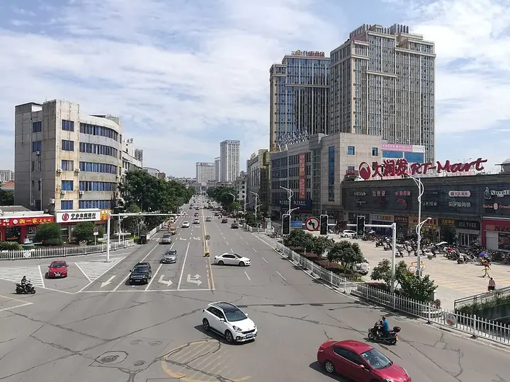
Photo adjustments
Full frame retained; proportionally resized and converted to WebP. No retouching or changes to the photographed subject. Card displays may crop the view.
- Administrative area
- County-level city · 县级市
- Part of
- Changsha
- Chinese name
- 宁乡市
- Local areas
- County-level city guide
Area & population
- Area in the source
- 2,906.00 km²
- Administrative seat
- Yutan
Source: cited geographic source, as of the dates shown.
Setting and landscape
Mountains ring the north, west and south, hills roll across the south-east, and the ground falls in steps from west to east. The west has 13 peaks above 800 metres, the highest being Wazizhai (瓦子寨) at 1,070.8 metres; the lowest point, 28.7 metres, is Tuantou Lake (团头湖) in Shuangjiangkou (双江口). Four main rivers drain the city: the Wei (沩水) and the Jin (靳江) flow into the Xiang, and the Chu (楚江) and Wu (乌江) feed the Wei. The city government describes the Huangcai Reservoir (黄材水库) as one of China's three great earth-dam water projects, and calls Ningxiang a home of rice and fish, pigs and tea.
History
A county was first set up here in 257 under the Wu kingdom, as Xinyang (新阳), with its seat at Changqiao, today's Hengshi (横市). It was renamed Xinkang (新康) in 280. The county of Ningxiang itself dates from 977, when parts of Yiyang (益阳), Changsha and Xiangxiang (湘乡) were combined and the seat moved to today's Yutan (玉潭). Ningxiang came under Changsha in 1983 and became a county-level city in 2017.
What to see
The Tanheli Site (炭河里遗址) lies on a terrace where the Duanxi stream (塅溪) meets the Wei in Huangcai town (黄材镇). Found in 1963 and excavated several times, it is described by the city government as the earliest Western Zhou walled town in southern China and the capital of a Western Zhou state; excavators found palace foundations, walls and tombs. It is a national key protected site and was named one of China's top ten archaeological discoveries of 2004. The city credits the area with more than 2,000 finds, including the Four-Goat Square Zun (四羊方尊), one of the Shang and Zhou bronzes found around Huangcai.
The Former Residence and Memorial of Liu Shaoqi (刘少奇故居和纪念馆) in Huaminglou town (花明楼镇) is also a national key protected site. In the west, Miyin Temple (密印寺) stands in the Weishan (沩山) national scenic area. Other sights include the Huitang (灰汤) hot springs, with water at 86 to 93 °C, the former residences of Xie Juezai (谢觉哉) and He Shuheng (何叔衡) in Shatian township (沙田乡), and the provincially protected tombs of Zhang Jun (张浚) and his son Zhang Shi (张栻) at Xiangzikou (巷子口).
Highlights
- Tanheli Site 炭河里遗址: Western Zhou walled town site in Huangcai; national key protected site and a top-ten archaeological discovery of 2004.
- Former Residence and Memorial of Liu Shaoqi 刘少奇故居和纪念馆: National key protected site in Huaminglou town.
- Miyin Temple 密印寺: Temple in the Weishan national scenic area in western Ningxiang.
- Huitang hot springs 灰汤温泉: Spring water at 86 to 93 °C in Huitang town.
- Huangcai Reservoir 黄材水库: Described by the city as one of China's three great earth-dam water projects.
Sources for this guide
自然地理 - 宁乡市政府门户网站 · Ningxiang Municipal People's Government
历史沿革 - 宁乡市政府门户网站 · Ningxiang Municipal People's Government
炭河里遗址 - 宁乡人文 - 宁乡市政府门户网站 · Ningxiang Municipal People's Government
宁乡市 - 维基百科,自由的百科全书 · Wikipedia (Chinese) · CC BY-SA 4.0
Original English written from the listed sources and checked sentence by sentence against quoted extracts by a separate reviewer. Updated 2026-09-25.
Explore Ningxiang
Core places to explore, with English and Chinese names.
Places to explore around Ningxiang
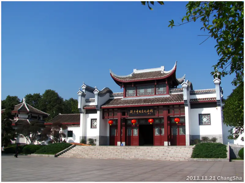 Huaminglou and Liu Shaoqi Memorial (花明楼景区), Ningxiang. Photograph: "少奇故里-纪念馆 - panoramio".
Huaminglou and Liu Shaoqi Memorial花明楼景区
Huaminglou in Ningxiang is centred on Liu Shaoqi's former home and memorial museum.
Read the place guide →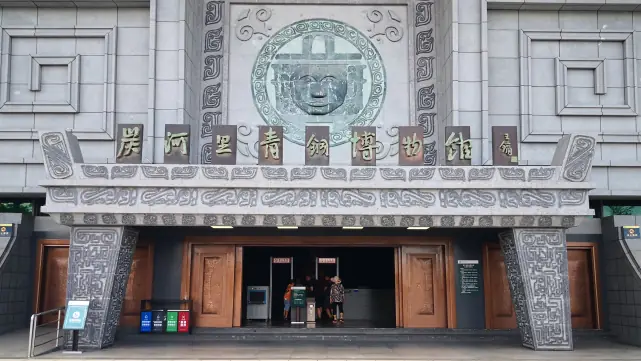 Tanheli Site Museum · 炭河里遗址博物馆
Tanheli Site Museum炭河里遗址博物馆
The museum at the Tanheli site (炭河里遗址博物馆), officially the Tanheli Bronze Museum, stands beside the Tanheli archaeological site at Huangcai in Ningxiang, a county-level city under Changsha in Hunan, and presents the bronze-age settlement excavated there.
Read the place guide →Huaminglou Hometown of Liu Shaoqi (花明楼刘少奇故里), Ningxiang. Photograph: "少奇故里-纪念馆 - panoramio".Huaminglou Hometown of Liu Shaoqi花明楼刘少奇故里
Huaminglou (花明楼刘少奇故里) at Tanzichong village in Ningxiang, a county-level city under Changsha in Hunan, is the birthplace of Liu Shaoqi, a leader of the Chinese Communist Party and of the People's Republic, and is now a memorial complex built around his family farmhouse.
Read the place guide →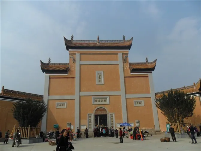 The shanmen gate of Miyin Temple on Wei Mountain, Ningxiang · 宁乡沩山密印寺山门 Source-recorded photograph date: 2011.
Weishan Miyin Temple沩山密印寺
Ancestral temple of the Weiyang school on Mount Wei in Ningxiang, Hunan, founded in 807, with a hall of 12,182 gilded Buddhas.
Read the place guide →Plan your visit
Getting there
Ningxiang is about 40 km in a straight line from central Changsha. Search for 宁乡市 in a map app to find stations and your accommodation.
Where to stay →Build your route
Huaminglou and Liu Shaoqi Memorial and Tanheli Site Museum are both listed here. The linked place guides have entrance and visit details.
Continue with Changsha →More in Changsha
Sources & geographic information
Administrative names and parent areas: Official geographic directory · Reference date 2026-09-06.
Some facts checked against 宁乡市 — Wikipedia contributors, CC BY-SA 4.0.
Photo: Huaminglou and Liu Shaoqi Memorial · 蒋鹏飞 · CC BY 3.0. Full frame retained; EXIF orientation normalized, proportionally resized to at most 800 pixels and converted to WebP. No generated pixels or subject changes. Cards may crop the display.

Photo: Tanheli Site Museum · Source photographer · License not provided. EXIF orientation normalized; resized without changing aspect ratio; converted to WebP. No subject edits.
Photo: Huaminglou Hometown of Liu Shaoqi · 蒋鹏飞 · CC BY 3.0. Full frame retained; EXIF orientation normalized, proportionally resized to at most 800 pixels and converted to WebP. No generated pixels or subject changes. Cards may crop the display.
Photo: Weishan Miyin Temple · Huangdan2060 · Public domain. Full frame retained; proportionally resized and converted to WebP. No retouching or changes to the photographed subject. Card displays may crop the view.

Map data © OpenStreetMap contributors. Pins mark approximate centres, not entrances or boundaries.