


Get to know Ewenki Autonomous Banner
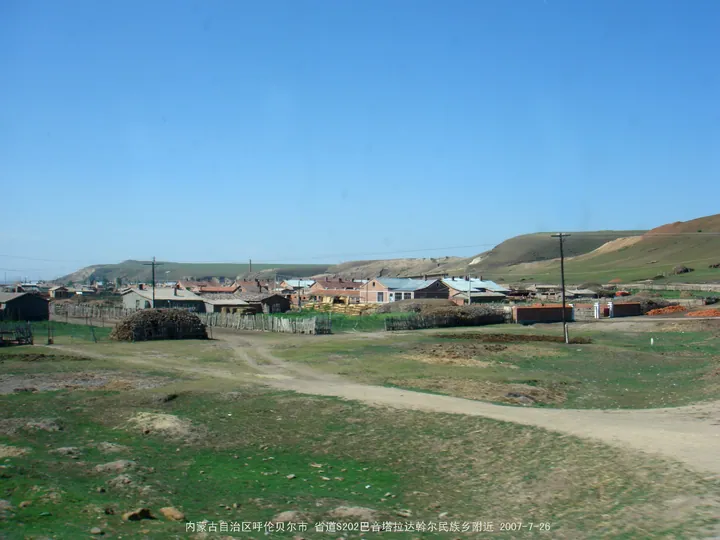
Photo adjustments
Full frame retained; proportionally resized and converted to WebP. No retouching or changes to the photographed subject. Card displays may crop the view.
- Administrative area
- Autonomous banner · 自治旗
- Part of
- Hulunbuir
- Chinese name
- 鄂温克族自治旗
- Local areas
- Autonomous banner guide
Area & population
- Area in the source
- 19,111.00 km²
- Population · 2020
- 141,102
- Administrative seat
- Bayan Tohoi
Source: cited geographic source, as of the dates shown.
Setting and landscape
The banner is a transition from the Greater Khingan uplands to the Hulunbuir high plain, sloping from south-east to north-west; the highest point is 1,706.6 metres. Grassland covers 62.2 per cent of the land and forest 33.8 per cent. The Yimin River (伊敏河), the largest river, runs south to north through the whole banner and joins the Hailar River (海拉尔河) by way of Hailar District. Its largest tributary, the Hui River (辉河), lies entirely within the banner, and a 150-kilometre marsh along its middle and lower reaches holds continuous natural reed beds. The banner government describes its sandy-land belt of Mongolian Scots pine (樟子松) as world-famous and its pine seed-tree forest as the largest in China.
History
When Temüjin (铁木真) divided his lands, Hulunbuir went to his brothers Qasar (拙赤哈撒儿) and Temüge (斡赤斤). Three ruined towns in Hui Sumu (辉苏木), Xiao Haotehan (小浩特罕古城), Da Haotehan (大浩特罕古城) and Bayan Ula (巴彦乌拉古城), were chief seats of Temüge and his family. In 1732 the Qing brought 3,000 men into Hulunbuir and enrolled them in the Eight Banners; most were Solon, so the group was called the Solon division. The Ewenki Museum (鄂温克博物馆) at 73 Yimin Road in Bayan Tohoi has history, folk-custom, Solon and nature halls; its history hall covers Evenki officers and soldiers who served the Qing in the Kangxi and Qianlong reigns.
What to see
The Aobao Xianghui Scenic Area (敖包相会景区), begun in 1989, is where the classic film "草原上的人们" ("People on the Grassland") was shot and where the song "敖包相会" ("Meeting at the Aobao") spread from; the banner's tourism bureau calls the song the "first love song of the East". The site now has an intangible-heritage hall and food area. Other sights named by Chinese Wikipedia include the Honghuaerji Mongolian Scots Pine National Forest Park (红花尔基樟子松国家森林公园).
Food and local products
Among the banner's wild species of food or economic value, the banner government names day lilies (黄花菜) and grassland white mushrooms (草原白蘑).
Getting oriented
The Yimin and Yimin–Arxan railways (伊敏铁路, 伊阿铁路) serve the banner, while the Binzhou railway (滨洲铁路) touches only Dayan (大雁镇) in the north-east.
Highlights
- Aobao Xianghui Scenic Area 敖包相会景区: Filming place of "People on the Grassland" and home of the song "Meeting at the Aobao"; begun in 1989.
- Ewenki Museum 鄂温克博物馆: Halls on history, folk customs, the Solon and nature in Bayan Tohoi.
- Honghuaerji Mongolian Scots Pine National Forest Park 红花尔基樟子松国家森林公园: Named by Chinese Wikipedia among the banner's sights.
- Ruined towns of Hui Sumu 辉苏木: Three ruined towns that were chief seats of Temüge, Temüjin's youngest brother.
Sources for this guide
鄂温克族自治旗 - 维基百科,自由的百科全书 · Chinese Wikipedia · CC BY-SA 4.0
鄂温克族自治旗概况-鄂温克族自治旗人民政府 · Ewenki Autonomous Banner People's Government Office
鄂温克博物馆-鄂温克族自治旗人民政府 · Ewenki Autonomous Banner Culture, Sports, Tourism, Radio and Television Bureau
呼伦贝尔敖包相会景区-鄂温克族自治旗人民政府 · Ewenki Autonomous Banner Culture, Sports, Tourism, Radio and Television Bureau
Original English written from the listed sources and checked sentence by sentence against quoted extracts by a separate reviewer. Updated 2026-09-26.
Explore Ewenki Autonomous Banner
Core places to explore, with English and Chinese names.
Ewenki Autonomous Banner 鄂温克族自治旗
Plan your visit
Getting there
Ewenki Autonomous Banner is about 7 km in a straight line from central Hulunbuir. Search for 鄂温克族自治旗 in a map app to find stations and your accommodation.
Where to stay →More in Hulunbuir
Sources & geographic information
Administrative names and parent areas: Official geographic directory · Reference date 2026-09-06.
Some facts checked against 鄂温克族自治旗 — Wikipedia contributors, CC BY-SA 4.0.
Map data © OpenStreetMap contributors. Pins mark approximate centres, not entrances or boundaries.