


Get to know New Barag Left Banner
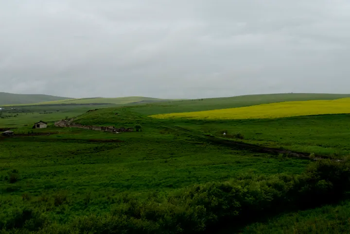
Photo adjustments
Full frame retained; proportionally resized and converted to WebP. No retouching or changes to the photographed subject. Card displays may crop the view.
- Administrative area
- Banner · 旗
- Part of
- Hulunbuir
- Chinese name
- 新巴尔虎左旗
- Local areas
- Banner guide
Area & population
- Area in the source
- 20,107.18 km²
- Population · 2020
- 37,007
- Administrative seat
- Amgalang
Source: cited geographic source, as of the dates shown.
Setting and landscape
The banner stretches 309 kilometres north to south and at most 165 kilometres east to west, with 215 kilometres of border with Mongolia and 96 with Russia. Its high plain lies between 560 and 800 metres and slopes down from south-east to north-west. In the south-east the land climbs onto the western edge of the Greater Khingan Range (大兴安岭), reaching 1,573 metres on Mount Urgen (乌尔根乌拉山) in Ubur Boolog Sumu (乌布尔宝力格苏木).
History
The Barag (巴尔虎) are a tribe of the Khalkha Mongols. This group reached Hulunbuir two years after the Barag of neighbouring Chen Barag Banner, hence 'New'; 'Left' means east in Mongolian. Chinese Wikipedia records that in 1734, 2,984 Barag soldiers moved with their families from around Lake Baikal, and the four left-wing banners were stationed along the lower Halha (哈拉哈河), Orshun (乌尔逊河) and Hailar rivers and on the east shore of Hulun Lake (呼伦湖). In 1927 the banner office settled at Thirteen Obo (十三敖包), today's Amugulang, after nearly two centuries on the move. Manchukuo merged the four banners in 1932, and the present name dates from 1959.
What to see
Ganjur Monastery (甘珠尔庙), also called Shouning Temple (寿宁寺), is a Gelug Tibetan Buddhist monastery 20 kilometres north-west of Amugulang. Building began in 1781, the Qianlong Emperor wrote its name plaque in 1785, and it is named after a copy of the Tibetan Kangyur (甘珠尔) it once kept. The banner government decided to rebuild it in early 2001, and it was reconsecrated in July 2003. A temple fair is held on the 19th day of the sixth lunar month, and during the autumn assembly from the 10th to the 15th of the eighth a naadam (那达慕) festival is held alongside the rites. Chinese Wikipedia also lists the Dular post station (杜拉尔驿站), Nogan Lake (诺干湖), the Barag Mongol Tribe scenic area (巴尔虎蒙古部落景区) and the Ebudug border port (额布都格口岸) among the banner's sights.
Food and local products
The banner government describes the dairy 'white foods' of the Barag grassland. Milk skin (奶皮子) is the fatty film lifted from slowly simmered milk and hung up to dry. Dried curd (奶干), about ten parts of milk to one, is cut with horsehair or thread and left on boards to dry for several days. Milk tofu (奶豆腐) is pressed into wooden moulds, some carved with patterns. Pot tea (锅茶) is milk tea cooked in the pot with dried meat, cheese and milk skin added as it is eaten.
Highlights
- Ganjur Monastery 甘珠尔庙: Gelug monastery begun in 1781, plaque by the Qianlong Emperor; rebuilt from 2001 and reconsecrated in 2003; naadam at its autumn assembly.
- Milk tofu 奶豆腐: Barag dairy curd pressed into wooden moulds, some carved with patterns.
- Pot tea 锅茶: Milk tea cooked with dried meat, cheese and milk skin in the pot.
Sources for this guide
新巴尔虎左旗概况 · New Barag Left Banner People's Government
新巴尔虎左旗 · Wikipedia (Chinese) · CC BY-SA 4.0
巴尔虎草原特色美食之白食 · New Barag Left Banner People's Government
甘珠尔庙 (呼伦贝尔) · Wikipedia (Chinese) · CC BY-SA 4.0
Original English written from the listed sources and checked sentence by sentence against quoted extracts by a separate reviewer. Updated 2026-09-25.
Explore New Barag Left Banner
Core places to explore, with English and Chinese names.
New Barag Left Banner 新巴尔虎左旗
Plan your visit
Getting there
New Barag Left Banner is about 155 km in a straight line from central Hulunbuir. Search for 新巴尔虎左旗 in a map app to find stations and your accommodation.
Where to stay →More in Hulunbuir
Sources & geographic information
Administrative names and parent areas: Official geographic directory · Reference date 2026-09-06.
Some facts checked against 新巴尔虎左旗 — Wikipedia contributors, CC BY-SA 4.0.
Some facts checked against 甘珠尔庙 (呼伦贝尔) — Wikipedia contributors, CC BY-SA 4.0.
Map data © OpenStreetMap contributors. Pins mark approximate centres, not entrances or boundaries.