


Get to know Hailar District
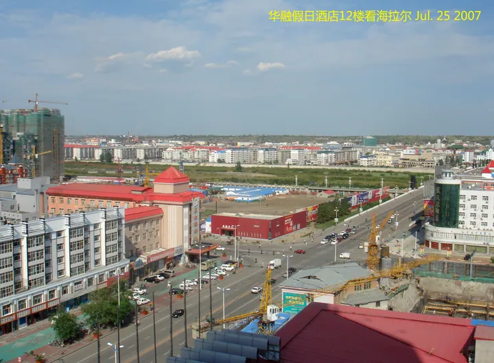
Photo adjustments
Full frame retained; proportionally resized and converted to WebP. No retouching or changes to the photographed subject. Card displays may crop the view.
- Administrative area
- District · 市辖区
- Part of
- Hulunbuir
- Chinese name
- 海拉尔区
- Local areas
- District guide
Area & population
- Area in the source
- 1,319.80 km²
- Population · 2020
- 365,012
- Administrative seat
- Zhengyang Subdistrict
Source: cited geographic source, as of the dates shown.
Setting and landscape
The district government places Hailar on the seam between the low hills of the western foot of the Greater Khingan Range (大兴安岭) and the Hulunbuir high plain, inside what it calls the Hailar inland rift basin. The ground is higher in the east than in the west, with elevations between 603.0 and 776.6 metres. The name comes from the Hailar River, which the district government glosses as the river with wild chives growing on the pastures along both banks.
Chinese Wikipedia describes the climate as windy and dry in spring, cool and short in summer when most of the rain falls, quick to cool and frost in autumn, and long and severe in winter, with snow lying on the ground for much of it.
History
The Qing set up an administration here in 1732 and founded the town in 1734. According to Chinese Wikipedia, the town stood on the left bank of the Yimin River and was named Hulunbuir City because it lay between Hulun Lake and Buir Lake; it came to be called Hailar after the nearby river. In 1920 Hulun County (呼伦县) was created to handle Han Chinese affairs. Under Manchukuo, Hailar became the capital of Xing'an North Province (兴安北省) in 1934 and a city in 1940. Between 1969 and 1979 it was governed from Heilongjiang along with the rest of Hulunbuir League, and in 2002 the city of Hailar became a district.
What to see
The World Anti-Fascist War Hailar Memorial Park (世界反法西斯战争海拉尔纪念园) occupies the site of the Japanese army's Hailar fortress on the city's North Hill (北山). The district government describes the fortress as the most complex, largest and best-preserved ring of above- and below-ground works of its kind surviving in China. The park is a national AAAA scenic area and a key cultural relic protection unit of Inner Mongolia. Its museum covers 4,300 square metres in four halls; 450 metres of underground passages can be walked, with the headquarters, soldiers' quarters, medical room and signals room restored; and an 18-metre sculpture shows Chinese, Soviet and Mongolian soldiers of the war.
Getting oriented
The district stretches 77 kilometres east to west and 40 kilometres north to south, bordered by the Ewenki Autonomous Banner (鄂温克族自治旗) to the east and south and by Chen Barag Banner (陈巴尔虎旗) to the west and north. The nearest point of the Russian border is 110 kilometres away and of the Mongolian border 160 kilometres. National Highway 332 passes through.
Highlights
- World Anti-Fascist War Hailar Memorial Park 世界反法西斯战争海拉尔纪念园: Former Japanese Hailar fortress on North Hill with a museum and 450 metres of walkable underground passages; national AAAA scenic area.
Sources for this guide
海拉尔区行政区划 · Hailar District People's Government
海拉尔区地形地貌 · Hailar District People's Government
世界反法西斯战争海拉尔纪念园 · Hailar District People's Government
海拉尔区 · Wikipedia (Chinese) · CC BY-SA 4.0
Original English written from the listed sources and checked sentence by sentence against quoted extracts by a separate reviewer. Updated 2026-09-25.
Explore Hailar District
Core places to explore, with English and Chinese names.
Hailar District 海拉尔区
Plan your visit
Getting there
Hailar District is about 5 km in a straight line from central Hulunbuir. Search for 海拉尔区 in a map app to find stations and your accommodation.
Where to stay →More in Hulunbuir
Sources & geographic information
Administrative names and parent areas: Official geographic directory · Reference date 2026-09-06.
Some facts checked against 海拉尔区 — Wikipedia contributors, CC BY-SA 4.0.
Map data © OpenStreetMap contributors. Pins mark approximate centres, not entrances or boundaries.