


Get to know New Barag Right Banner
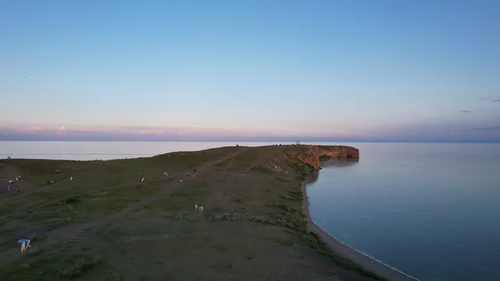
Photo adjustments
Full frame retained; proportionally resized and converted to WebP. No retouching or changes to the photographed subject. Card displays may crop the view.
- Administrative area
- Banner · 旗
- Part of
- Hulunbuir
- Chinese name
- 新巴尔虎右旗
- Local areas
- Banner guide
Area & population
- Area in the source
- 24,839.47 km²
- Population · 2020
- 38,358
- Administrative seat
- Altan Emel
Source: cited geographic source, as of the dates shown.
Setting and landscape
The banner government puts usable grassland at 20,500 square kilometres, 81.3 per cent of the banner. The Kherlen River (克鲁伦河) rises on the eastern slopes of the Khentii Mountains in Mongolia, crosses into China and flows east past the banner seat, Altan Emel (阿拉坦额莫勒镇), into Hulun Lake; about 206 of its 1,264 kilometres lie in China.
The banner government lists Hulun Lake (呼伦湖), also called Dalai Lake (达赉湖), as the largest lake in Inner Mongolia: 2,339 square kilometres of fresh water at 545.5 metres, a rift lake formed in the late Jurassic. It belongs to the Dalai Lake National Nature Reserve (达赉湖国家级自然保护区), where 303 bird species have been recorded, including red-crowned and Siberian cranes. Some 100 kilometres from Altan Emel, Buir Lake (贝尔湖) straddles the Mongolian border: of its 628.78 square kilometres only the north-western 40.26 are Chinese. It is fed mainly by the Halha River (哈拉哈河), and the Orshun River (乌尔逊河) links it from the north to Hulun Lake. Both names come from Mongolian words for the otter.
History
The banner government ties the Kherlen to the youth of Genghis Khan: the Tatars poisoned his father Yesugei (也速该) on its banks, and in the twelfth century the Khongirad (弘吉拉部), the people of his wife Börte (孛儿帖), lived from the lower Kherlen to Hulun Lake.
Dashi Pengsige Temple (达西朋斯格庙), known locally as the West Temple, stands 10 kilometres east of Altan Emel. This Tibetan Buddhist monastery was built in 1854; parts of it were badly damaged during the Cultural Revolution, it was restored in 1985, and it is now a key cultural relic protection unit of Inner Mongolia. Week-long temple fairs are held from the sixth day of the fourth and of the sixth lunar months.
Food and local products
Barag lamb rolls (巴尔虎羊肉卷) are the banner's specialty, made in two main kinds, from lamb and from mature sheep, and used for hotpot. On Buir Lake the catch of carp, catfish and whitefish goes into the Buir whole-fish banquet (贝尔全鱼宴).
Highlights
- Hulun Lake 呼伦湖: Listed by the banner government as Inner Mongolia's largest lake; part of the Dalai Lake National Nature Reserve.
- Buir Lake 贝尔湖: Border lake shared with Mongolia; only 40.26 square kilometres in its north-west are Chinese.
- Dashi Pengsige Temple 达西朋斯格庙: Tibetan Buddhist monastery built in 1854, 10 km east of Altan Emel; a regional key cultural relic protection unit.
- Barag lamb rolls 巴尔虎羊肉卷: Lamb and mutton rolls for hotpot, named by the banner government as a local specialty.
Sources for this guide
地理位置 · New Barag Right Banner People's Government
呼伦湖 · New Barag Right Banner People's Government
巴尔虎宗教圣地---达西朋斯格庙 · New Barag Right Banner People's Government
品羊肉 · New Barag Right Banner People's Government
中蒙界湖—贝尔湖 · New Barag Right Banner People's Government
蒙古族的母亲河—克鲁伦河 · New Barag Right Banner People's Government
Original English written from the listed sources and checked sentence by sentence against quoted extracts by a separate reviewer. Updated 2026-09-25.
Explore New Barag Right Banner
Core places to explore, with English and Chinese names.
New Barag Right Banner 新巴尔虎右旗
Plan your visit
Getting there
New Barag Right Banner is about 225 km in a straight line from central Hulunbuir. Search for 新巴尔虎右旗 in a map app to find stations and your accommodation.
Where to stay →More in Hulunbuir
Sources & geographic information
Administrative names and parent areas: Official geographic directory · Reference date 2026-09-06.
Map data © OpenStreetMap contributors. Pins mark approximate centres, not entrances or boundaries.