


Get to know Genhe

Photo adjustments
Full frame retained; proportionally resized and converted to WebP. No retouching or changes to the photographed subject. Card displays may crop the view.
- Administrative area
- County-level city · 县级市
- Part of
- Hulunbuir
- Chinese name
- 根河市
- Local areas
- County-level city guide
Area & population
- Area in the source
- 19,659.00 km²
- Population · 2020
- 71,437
- Administrative seat
- Hexi Subdistrict
Source: cited geographic source, as of the dates shown.
Setting and landscape
The Jingling ridge (静岭) splits the city between the Gen River basin to the south and the Jiliu River (激流河) basin to the north. More than 700 peaks top 1,000 metres, most of them gently rounded with flat summits; the highest, Aokeliedui (奥科里堆山) in Alongshan (阿龙山镇), reaches 1,530 metres, and Chinese Wikipedia names it the highest peak of the northern Greater Khingan as well. Chinese Wikipedia describes Genhe as the coldest place in the world at its latitude, with a mean temperature of -5.3°C and a recorded low of -58°C. Dahurian larch (兴安落叶松) makes up 76 per cent of the forest, and in the primeval forest of the north grow 61 Siberian pines that Evenki hunters regard as sacred trees. At Mangui (满归), a stretch of the Jiliu nearly 100 metres long stays unfrozen even at -40°C, which the city's media centre puts down to geothermal heat beneath the riverbed.
What to see
Chinese Wikipedia calls Aoluguya Evenki Ethnic Township (敖鲁古雅鄂温克民族乡) China's only "home of reindeer". Its Evenki once lived deep in the forest by hunting and reindeer herding and were known as "China's last hunting tribe"; in 2003 they gave up the hunting life, and the township was moved south to a site 3 kilometres from the city. At the Aoluguya Reindeer Tribe Scenic Area (敖鲁古雅使鹿部落景区) visitors feed the reindeer moss, ride reindeer or, in winter, take reindeer sleds, and the Aoluguya Evenki Reindeer Culture Museum (敖鲁古雅鄂温克族驯鹿文化博物馆) tells the community's story.
The China Cold Pole Village (中国冷极村) serves a local set of dishes called "冷极八大碗" ("the cold pole's eight big bowls"); the China Cold Pole Festival (中国冷极节) reached its eleventh edition in winter 2024–2025. Other sights include the Genheyuan National Wetland Park (根河源国家湿地公园), Mangui town, the Yikesama National Forest Park (伊克萨玛国家森林公园) and Kalubenshan (卡鲁本山).
Getting oriented
The Yalin railway (牙林铁路) runs north to south through the city, and national roads G332 and G605 pass through it. Genhe Aoluguya Airport (根河敖鲁古雅机场), a general-aviation field, lies about 14 kilometres south-west of the city centre.
Highlights
- Aoluguya Reindeer Tribe Scenic Area 敖鲁古雅使鹿部落景区: Reindeer park, reindeer rides and sleds, and a museum of Evenki reindeer culture.
- China Cold Pole Village 中国冷极村: Serves the "eight big bowls" set of local dishes.
- Unfrozen stretch of the Jiliu River 激流河: Nearly 100 metres at Mangui that stays unfrozen at -40°C.
- Aokeliedui Mountain 奥科里堆山: 1,530 metres; named by Chinese Wikipedia as the highest peak of the northern Greater Khingan.
Sources for this guide
根河市 - 维基百科,自由的百科全书 · Chinese Wikipedia · CC BY-SA 4.0
“中国冷极”根河市:白色诗画引客来-根河市人民政府 · Genhe Media Centre, on the Genhe city government portal
满归镇现“不冻河”景观-根河市人民政府 · Genhe Media Centre, on the Genhe city government portal
敖鲁古雅使鹿部落景区奏响夏日旅游“交响曲”-根河市人民政府 · Genhe Media Centre, on the Genhe city government portal
Original English written from the listed sources and checked sentence by sentence against quoted extracts by a separate reviewer. Updated 2026-09-26.
Explore Genhe
Core places to explore, with English and Chinese names.
Places to explore around Genhe
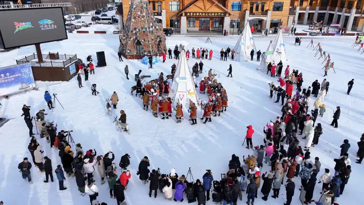 Aoluguya Reindeer Tribe Scenic Area ·
 Plan your visit
Getting there
Genhe is about 215 km in a straight line from central Hulunbuir. Search for 根河市 in a map app to find stations and your accommodation.
Where to stay →Build your route
Start with Aoluguya Reindeer Tribe Scenic Area. The linked place guides have entrance and visit details.
Continue with Hulunbuir →More in Hulunbuir
Sources & geographic information
Administrative names and parent areas: Official geographic directory · Reference date 2026-09-06.
Some facts checked against 根河市 — Wikipedia contributors, CC BY-SA 4.0.
Photo: Aoluguya Reindeer Tribe Scenic Area · Source photographer · License not provided. EXIF orientation normalized; resized without changing aspect ratio; converted to WebP. No subject edits.
Map data © OpenStreetMap contributors. Pins mark approximate centres, not entrances or boundaries.