


Get to know Zalantun
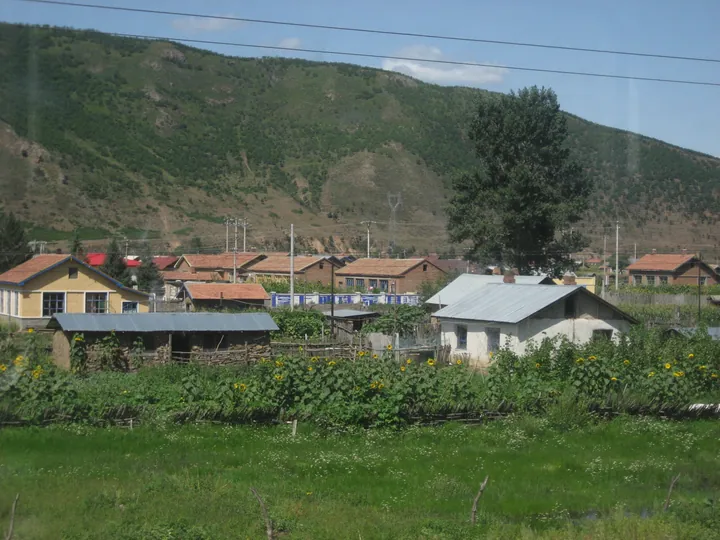
Photo adjustments
Full frame retained; proportionally resized and converted to WebP. No retouching or changes to the photographed subject. Card displays may crop the view.
- Administrative area
- County-level city · 县级市
- Part of
- Hulunbuir
- Chinese name
- 扎兰屯市
- Local areas
- County-level city guide
Area & population
- Area in the source
- 16,800.00 km²
- Population · 2020
- 318,933
- Administrative seat
- Xinghua Subdistrict
Source: cited geographic source, as of the dates shown.
Setting and landscape
Several borders follow natural or old man-made lines. The Yin River (音河) separates it from Arun Banner (阿荣旗) to the east, and the Jin-dynasty Great Wall (金长城) marks the southern edge with Heilongjiang and Jalaid Banner (扎赉特旗). Chinese Wikipedia sums up the land use as seven parts forest, two parts grassland and one part farmland; People's Daily counts more than 60 rivers.
The Yalu River (雅鲁河) gave its name to Yalu County (雅鲁县), set up in 1929. Leaving the mountains, the river spreads into an alluvial fan dotted with small wooded islands, the Xiushui (秀水) area north of the city. Its forests and grasslands yield hazelnuts, bracken, daylilies and lion's mane mushrooms.
History
The old name Butha (布特哈) means "fishing and hunting", and the Kangxi court set up a Butha administration office here. People's Daily says the town takes its name from a Qing official titled jalan janggin (札兰章京) who was stationed here in 1691, and that the Chinese Eastern Railway (中东铁路) turned it into a railway stop around 1900. In May 1946 the Nawen Muren Province (纳文慕仁省), named from the Daur word for the Nen River, had its seat in Zalantun. Butha Banner became Zalantun city on 10 October 1983.
What to see
The Inner Mongolia Chinese Eastern Railway Museum (内蒙古中东铁路博物馆), converted from a former railway club in 2008, is described by People's Daily as the first museum in China devoted to the railway; a steam locomotive stands on its forecourt. The Zalantun History Museum (扎兰屯市历史博物馆) occupies a 1903 building that served as the railway club and later as a Manchukuo-era hot-spring hotel. On the city's north side, Suspension Bridge Park (吊桥公园) covers 68 hectares, and Xiushui National Wetland Park (秀水国家湿地公园) lies 4 kilometres north of the city.
The Chaihe scenic area (柴河景区) in Chaihe Town, about 175 kilometres southwest of the city, is the core of the Zalantun national scenic area and contains Chaihe Moon Town (柴河月亮小镇). The Hulunbuir culture and tourism bureau records 15 volcanic craters there, seven of them crater lakes above 1,000 metres, including Moon Lake (月亮天池) and Tongxin Lake (同心天池), plus fields of dark basalt. In 2017 Chaihe was named a 5A scenic area together with Arxan (阿尔山).
Food and local products
Zalantun black fungus (扎兰屯黑木耳) was selected in 2017 for the China-EU "100+100" mutual recognition and protection list. The Ministry of Agriculture lists most of Zalantun's crab-apple orchards as a national green-food raw-material base, and feather painting and birch-bark craft are on Hulunbuir's intangible heritage list.
Highlights
- Inner Mongolia Chinese Eastern Railway Museum 内蒙古中东铁路博物馆: Converted from a railway club in 2008; People's Daily calls it the first museum in China on the Chinese Eastern Railway.
- Chaihe Moon Town 柴河月亮小镇: In the Chaihe scenic area, where seven of 15 volcanic craters hold lakes above 1,000 metres.
- Xiushui National Wetland Park 秀水国家湿地公园: Lies 4 km north of the city on the Yalu River's alluvial fan.
- Zalantun black fungus 扎兰屯黑木耳: Selected in 2017 for the China-EU 100+100 mutual recognition and protection list.
Sources for this guide
扎兰屯市(内蒙古年鉴2018卷) · Inner Mongolia Party History and Local Chronicles Office (内蒙古区情网)
招商引资|月亮天池旅游产业招商引资项目-呼伦贝尔市文化旅游广电局 · Hulunbuir Culture, Tourism, Radio and Television Bureau
璀璨明珠扎兰屯(行天下) · People's Daily Overseas Edition
扎兰屯市 - 维基百科,自由的百科全书 · Wikipedia (Chinese) · CC BY-SA 4.0
Original English written from the listed sources and checked sentence by sentence against quoted extracts by a separate reviewer. Updated 2026-09-26.
Explore Zalantun
Core places to explore, with English and Chinese names.
Places to explore around Zalantun
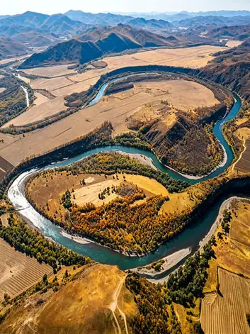 Chaihe Moon Town ·
 Plan your visit
Getting there
Zalantun is about 255 km in a straight line from central Hulunbuir. Search for 扎兰屯市 in a map app to find stations and your accommodation.
Where to stay →Build your route
Start with Chaihe Moon Town. The linked place guides have entrance and visit details.
Continue with Hulunbuir →More in Hulunbuir
Sources & geographic information
Administrative names and parent areas: Official geographic directory · Reference date 2026-09-06.
Some facts checked against 扎兰屯市 — Wikipedia contributors, CC BY-SA 4.0.
Photo: Chaihe Moon Town · Source photographer · License not provided. EXIF orientation normalized; resized without changing aspect ratio; converted to WebP. No subject edits.
Map data © OpenStreetMap contributors. Pins mark approximate centres, not entrances or boundaries.