


Get to know Heishui County
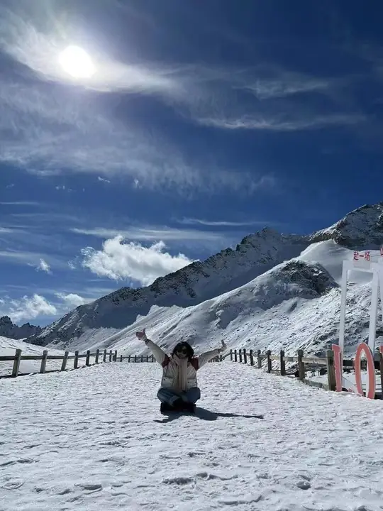
Photo adjustments
The exact downloaded source bytes are separately retained and hashed. Prepared JPEG is proportionally reduced to a maximum 720-pixel long edge; full frame retained, no subject alteration. Final website rendition: full frame retained, proportionally resized to at most 720 pixels and converted to WebP. No additional retouching or subject alteration. Card displays may crop the view.
- Administrative area
- County · 县
- Part of
- Ngawa Tibetan and Qiang Autonomous Prefecture
- Chinese name
- 黑水县
- Local areas
- County guide
Area & population
- Area in the source
- 4,356.00 km²
- Population · 2020
- 44,564
- Administrative seat
- Doka (Luhua)
Source: cited geographic source, as of the dates shown.
Ice above coloured woodland
Dagu Glacier (达古冰川) and the Naizigou Autumn Forest (奶子沟彩林) are two of the county’s named natural attractions. Sichuan Online describes autumn colour progressing by elevation from late September to mid-November, with red, gold, orange and green foliage. Boardwalks, white towers and Tibetan villages appear among the Naizigou woodland. Other landscapes include San’ao Snow Mountains (三奥雪山) and the Tibetan villages of Yangrong Hade (羊茸哈德) and Se’ergu (色尔古).
Rivers and the county seat
The county seat, Luhua (芦花), stands at an elevation of 2,350 metres. The Heishui River (黑水河), Mao’ergai River (毛儿盖河) and Xiaoheishui River (小黑水河) form a network of tributaries in the upper Min River (岷江) basin.
Sources for this guide
黑水县概况_黑水县人民政府 · Heishui County Government
探冰川、赏红叶,黑水第十一届冰川彩林生态文化旅游季27日启幕_四川在线 · Sichuan Online
Original English written from the listed sources and checked sentence by sentence against quoted extracts by a separate reviewer. Updated 2026-09-27.
Explore Heishui County
Core places to explore, with English and Chinese names.
Places to explore around Heishui County
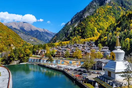 Naizigou Autumn Foliage · 奶子沟彩林
Naizigou Autumn Foliage奶子沟彩林
Naizigou is a valley in the north of Heishui County, in Sichuan's Aba Tibetan and Qiang Autonomous Prefecture, about 20 km from the county seat, whose mixed colour forest the county's own entry records as running for eighty li and names the 'eighty-li gallery'.
Read the place guide →Snow-covered viewing area at Dagu Glacier · 达古冰川雪地观景区 Photograph date recorded by the source: 12 November 2021.Dagu Glacier达古冰川
Dagu Glacier combines forested lakes and Tibetan cultural landscapes with a cable-car ascent to a much higher glacier-viewing area. Dagu Lake and Jinhou Lake offer a different experience from the exposed upper station, so the…
Read the place guide →Plan your visit
Getting there
Heishui County is about 85 km in a straight line from central Ngawa Tibetan and Qiang Autonomous Prefecture. Search for 黑水县 in a map app to find stations and your accommodation.
Where to stay →Build your route
Naizigou Autumn Foliage and Dagu Glacier are both listed here. The linked place guides have entrance and visit details.
Continue with Ngawa Tibetan and Qiang Autonomous Prefecture →More in Ngawa Tibetan and Qiang Autonomous Prefecture
Sources & geographic information
Administrative names and parent areas: Official geographic directory · Reference date 2026-09-06.
Photo: Naizigou Autumn Foliage · Source photographer · License not provided. EXIF orientation normalized; resized without changing aspect ratio; converted to WebP. No subject edits.
Photo: Dagu Glacier · 中文維基百科20021024 · 中文維基百科20021024 — 达古冰川.jpg — CC BY-SA 4.0 · CC BY-SA 4.0. The exact downloaded source bytes are separately retained and hashed. Prepared JPEG is proportionally reduced to a maximum 720-pixel long edge; full frame retained, no subject alteration. Final website rendition: full frame retained, proportionally resized to at most 720 pixels and converted to WebP. No additional retouching or subject alteration. Card displays may crop the view.

Map data © OpenStreetMap contributors. Pins mark approximate centres, not entrances or boundaries.