


Get to know Songpan County

Photo adjustments
The exact downloaded source bytes are separately retained and hashed. Prepared JPEG is proportionally reduced to a maximum 720-pixel long edge; full frame retained, no subject alteration. Final website rendition: full frame retained, proportionally resized to at most 720 pixels and converted to WebP. No additional retouching or subject alteration. Card displays may crop the view.
- Administrative area
- County · 县
- Part of
- Ngawa Tibetan and Qiang Autonomous Prefecture
- Chinese name
- 松潘县
- Local areas
- County guide
Area & population
- Area in the source
- 8,486.00 km²
- Population · 2020
- 66,937
- Administrative seat
- Jin'an
Source: cited geographic source, as of the dates shown.
History
The county government dates the first county-level unit here, Jiandi (湔氐县), to 316 BC, after Qin conquered Shu. In 618 the Tang set up Songzhou (松州) and began its walled town; the Battle of Songzhou led to the marriage alliance between the Tibetan king Songtsen Gampo (松赞干布) and Princess Wencheng (文成公主). In 1379 the Ming created the Songzhou and Panzhou (潘州) garrisons, later merged as the Songpan garrison, which gave the county its name. It became Songpan County in 1913. For centuries it was a military stronghold and a tea-horse trading hub between the Han lands and the Qiang and Tibetans.
Classical texts from the pre-Qin period to the early Republic placed the source of the Yangtze in the Min Mountains (岷山), following the line "from Minshan the river was led" (岷山导江) in the Tribute of Yu (禹贡). During the Long March, the Shawo (沙窝) and Maoergai (毛儿盖) meetings held in the county fixed the Red Army's strategy of heading north to resist Japan.
Qiang polyphonic singing (羌族多声部) is Songpan's national intangible-heritage item; provincial items include the Hui lantern dance (回族花灯舞), Tibetan thangka painting and Tibetan leatherwork. The county has 19 Tibetan Buddhist monasteries, 10 mosques and one gongbei shrine (拱北), and its gold, known as Zhang gold (漳金), is famous well beyond the county.
What to see
Huanglong (黄龙) is the county's one 5A scenic area, known for travertine shoals and terraced coloured pools below snow peaks. Munigou (牟尼沟), part of the Huanglong world natural heritage area, covers 160 square kilometres between 2,800 and 4,070 metres; it has two parts, Zhaga Waterfall (扎嘎瀑布) and Erdaohai (二道海), with forest, alpine lakes, hot springs, giant travertine falls and coloured pools.
The walls of the old city of Songzhou (松州古城) in Jin'an town (进安镇) are a national key protected site, listed in 2001. The inner city straddles the river and runs up the hillside in the shape of an isosceles triangle, with a barbican and an outer city. The other national protected sites are the Red Army Long March Monument park at Chuanzhusi (川主寺红军长征纪念碑碑园), built in 1989 with its name written by Deng Xiaoping, and the Maoergai and Shawo meeting sites. Huanglong Temple (黄龙寺) and the old wall of Xiaohe (小河古城墙) are provincial sites.
Highlights
- Huanglong Scenic and Historic Interest Area 黄龙风景名胜区: 5A scenic area of travertine shoals and terraced coloured pools.
- Songpan Ancient City 松潘古城: Triangular walled town with a barbican; its walls are a national key protected site listed in 2001.
- Munigou 牟尼沟: Zhaga Waterfall and Erdaohai, with travertine falls and pools, part of the Huanglong world heritage area.
- Red Army Long March Monument park 川主寺红军长征纪念碑碑园: Built at Chuanzhusi in 1989; a national key protected site.
Sources for this guide
松潘概况_松潘县人民政府 · Songpan County People's Government
黄龙_松潘县人民政府 · Songpan County People's Government
松州古城_松潘县人民政府 · Songpan County People's Government
牟尼沟_松潘县人民政府 · Songpan County People's Government
Original English written from the listed sources and checked sentence by sentence against quoted extracts by a separate reviewer. Updated 2026-09-25.
Explore Songpan County
Core places to explore, with English and Chinese names.
Places to explore around Songpan County
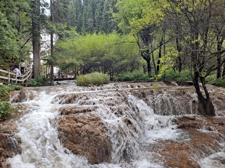 A travertine cascade waterfall along the forested boardwalk trail in Mouni Valley, Songpan County · 四川松潘县牟尼沟钙化瀑布 Source-recorded photograph date: 2023-09-11.
Mounigou Valley牟尼沟
Travertine valley in Songpan, Sichuan, with the tall Zhaga Waterfall and the forest lakes and hot springs of Erdaohai.
Read the place guide →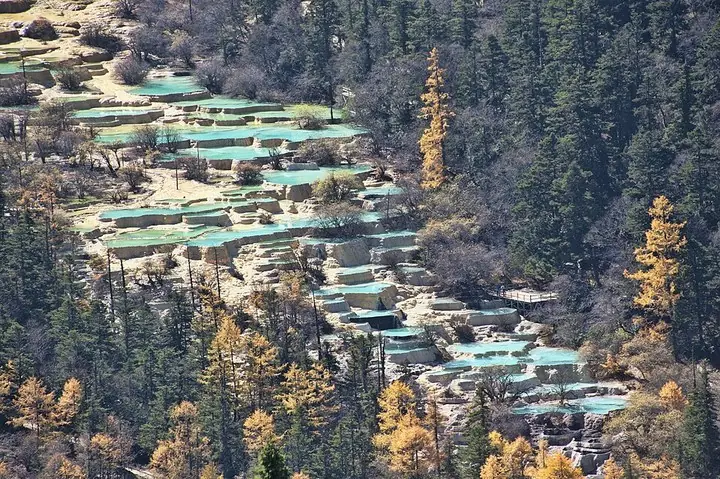 Travertine pools at Huanglong, Sichuan · 四川黄龙钙华彩池 Photograph date recorded by the source: 24 October 2011.
Huanglong Scenic and Historic Interest Area黄龙风景名胜区
Huanglong is a mountain valley distinguished by a sequence of travertine pools, mineral formations and waterfalls. The pale terraces and colored water are part of a natural system, set among forests and high peaks rather than…
Read the place guide →Songpan Ancient City wall and gate from above · 松潘古城城墙与城门俯瞰 Photograph date recorded by the source: 17 October 2023, 05:31:38.Songpan Ancient City松潘古城
Songpan’s old city is shaped by its fortified gates and the Min River running through the built-up area. Gusong Bridge gives a close view of the water and the houses along its banks, while the surrounding streets retain a busy…
Read the place guide →Plan your visit
Getting there
Songpan County is about 155 km in a straight line from central Ngawa Tibetan and Qiang Autonomous Prefecture. Search for 松潘县 in a map app to find stations and your accommodation.
Where to stay →Build your route
Mounigou Valley and Huanglong Scenic and Historic Interest Area are both listed here. The linked place guides have entrance and visit details.
Continue with Ngawa Tibetan and Qiang Autonomous Prefecture →More in Ngawa Tibetan and Qiang Autonomous Prefecture
Sources & geographic information
Administrative names and parent areas: Official geographic directory · Reference date 2026-09-06.
Photo: Mounigou Valley · EditQ · CC0. Full frame retained; proportionally resized and converted to WebP. No retouching or changes to the photographed subject. Card displays may crop the view.

Photo: Huanglong Scenic and Historic Interest Area · chensiyuan · chensiyuan — 1_huanglong_pools_aerial_2011.jpg — CC BY-SA 4.0 · CC BY-SA 4.0. The exact downloaded source bytes are separately retained and hashed. Prepared JPEG is proportionally reduced to a maximum 720-pixel long edge; full frame retained, no subject alteration. Final website rendition: full frame retained, proportionally resized to at most 720 pixels and converted to WebP. No additional retouching or subject alteration. Card displays may crop the view.

Photo: Songpan Ancient City · Bob Tan · Bob Tan — Aerial perspective of the Songpan Ancient City walls and fort. October 2023.jpg — CC BY 4.0 · CC BY 4.0. The exact downloaded source bytes are separately retained and hashed. Prepared JPEG is proportionally reduced to a maximum 720-pixel long edge; full frame retained, no subject alteration. Final website rendition: full frame retained, proportionally resized to at most 720 pixels and converted to WebP. No additional retouching or subject alteration. Card displays may crop the view.

Map data © OpenStreetMap contributors. Pins mark approximate centres, not entrances or boundaries.