


Get to know Qionglai

Photo adjustments
Full frame retained; resized proportionally to a maximum dimension of 960 pixels and converted to WebP quality 88. No crop, retouch, generated elements, or subject alteration. Final website rendition: full frame retained, proportionally resized to at most 720 pixels and converted to WebP. No additional retouching or subject alteration. Card displays may crop the view.
- Administrative area
- County-level city · 县级市
- Part of
- Chengdu
- Chinese name
- 邛崃市
- Local areas
- County-level city guide
Area & population
- Area in the source
- 1,377.00 km²
- Population · 2020 census
- 602,973
- Administrative seat
- Linqiong Subdistrict
Source: cited geographic source, as of the dates shown.
Setting and landscape
The east and north of Qionglai are flat plain, low hills roll across the south, and the west rises into ranges extending the southern Longmen Mountains (龙门山), with a transition belt of hills between them. China.org.cn places the city at the western rim of the plain, at a key point on the Sichuan–Tibet highway.
History
The Qin built the city of Linqiong on the site of today's town centre in 316 BC. Under the Ming and Qing it was Qiongzhou (邛州) prefecture, renamed Qionglai as a county in the Republican era; it passed to Chengdu in 1983 and became a county-level city on 6 June 1994. Local tradition places here the Western Han story of Zhuo Wenjun (卓文君) and Sima Xiangru (司马相如), who kept a wine shop together, and China.org.cn names Qionglai as the first stop of the Southern Silk Road.
What to see
Pingle Ancient Town (平乐古镇), a national historic town and 4A scenic area, keeps old streets, bridges and a weir; Sichuan University Museum describes it as the first post station on the Southern Silk Road. Mount Tiantai (天台山), also 4A, is a national forest park. Qionglai also counts part of the Sichuan Giant Panda Sanctuaries World Heritage site among its attractions.
The Qiong Kiln Site (邛窑遗址) at Shifangtang (十方堂) village began in the Southern Dynasties and flourished in the Tang and Five Dynasties; its 14 kiln mounds are preserved in an archaeological park with a museum of Tang coloured-glaze ware, and China.org.cn groups it with Sanxingdui and Jinsha as Sichuan's three archaeological parks. Other national protected sites include the stone pagoda of Shita Temple (石塔寺) and the Qionglai grottoes; the Wenjun Well (文君井) and Huilan Pagoda (回澜塔) are provincially protected.
Food and local products
Qionglai dark tea (邛崃黑茶), Qionglai black pigs and Qiong liquor (邛酒) carry national geographical indications, and Wenjun liquor (文君酒) is another local product. Qiong bamboo staffs (邛竹杖) are recorded as having been seen by Zhang Qian (张骞) on his mission to the Western Regions.
Highlights
- Pingle Ancient Town 平乐古镇: National historic town and 4A scenic area with old streets, bridges and a weir.
- Qiong Kiln Site 邛窑遗址: Kiln site begun in the Southern Dynasties and at its height in the Tang and Five Dynasties, with 14 preserved kiln mounds.
- Mount Tiantai 天台山: 4A scenic area and national forest park.
- Qionglai dark tea 邛崃黑茶: National geographical indication product.
Sources for this guide
邛崃市 - 维基百科,自由的百科全书 · Chinese Wikipedia · CC BY-SA 4.0
"醉美邛崃"亮出外宣新名片 "未来景区"令人期待 · China.org.cn, republished by People's Daily Online
春日博物馆全体同仁踏青游学活动记-四川大学博物馆 · Sichuan University Museum
Original English written from the listed sources and checked sentence by sentence against quoted extracts by a separate reviewer. Updated 2026-09-25.
Explore Qionglai
Core places to explore, with English and Chinese names.
Places to explore around Qionglai
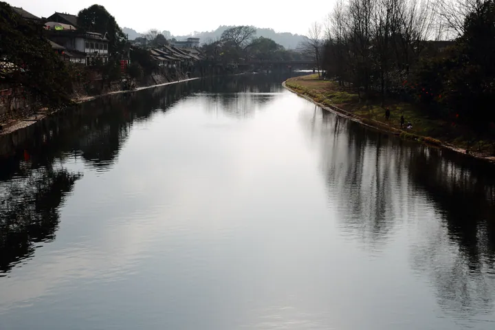 The canal running through Pingle Ancient Town, Qionglai, lined with traditional buildings · 邛崃平乐古镇沿河老街 Source-recorded photograph date: Taken on 19 January 2014.
Pingle Ancient Town平乐古镇
Pingle’s historic core follows the Baimo River, with riverside houses, old trees and stone-paved shopping lanes. Leshan Bridge gives the town a clear landmark and a useful starting point for understanding the old crossing and…
Read the place guide →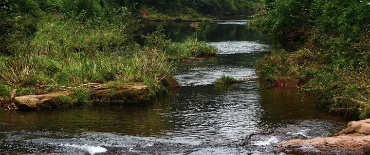 A forest stream at Tiantai Mountain, Qionglai · 邛崃天台山林间溪流 Source-recorded photograph date: Taken on 16 July 2011.
Tiantai Mountain, Qionglai邛崃天台山
Qionglai’s Tiantai Mountain is a forest-and-stream outing known for seasonal fireflies. Xiaojiawan and Zhengtiantai are named starting areas for different walks, while higher viewpoints can offer cloud and mountain scenery when…
Read the place guide → The Qiong Kiln Site Museum building and approach path, Qionglai · 邛崃市邛窑遗址博物馆及步道 Source-recorded photograph date: 2025-07-30.
Qiong Kiln Site邛窑遗址
Qiong Kiln Archaeological Park explains the ceramic industry that flourished around Qionglai. The Shifangtang site forms the visitor core, with protected kiln remains and exhibitions showing how local pottery was made and…
Read the place guide → Western Sichuan Bamboo Sea · 川西竹海
Western Sichuan Bamboo Sea川西竹海
Western Sichuan Bamboo Sea combines a bamboo-covered valley near Pingle with modern elevated walking facilities. The lower stream setting and Jinji bridge provide a quieter landscape, while high bridges and glass sections create…
Read the place guide →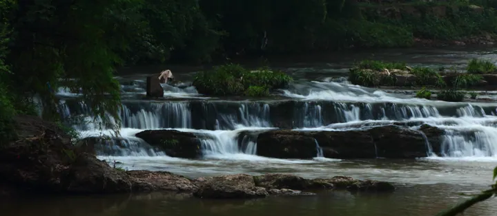 A stream dropping over a series of low rock ledges in small white cascades, brown water in the foreground, dark wet rock and thick green foliage on both banks, and one person standing on the rocks at the upper left.
Tiantai Mountain天台山
Tiantai Shan is a forested mountain in Tiantaishan town, Qionglai, Chengdu; its scenic area covers 192 square kilometres and its main summit, Yuxiao Feng, reaches 1,812 metres.
Read the place guide → Qiong Kiln Archaeological Park · 邛窑考古遗址公园
Qiong Kiln Archaeological Park邛窑考古遗址公园
The Qiong Kiln Archaeological Site Park at Qionglai, Chengdu, takes its name from the Qiong kilns, a ceramic industry that began under the Southern Dynasties and ended in the Song, and whose principal site at Shifangtang is a national key cultural relics protection unit.
Read the place guide →Local life & food
Qionglai local specialties
邛崃市特色美食 · 1 specialties to discover
 Qionglai milk-broth noodles 奶汤面AI illustration · AI 示意图
The noodles are smooth and springy, surrounded by a savory, full-bodied soup. A meat topping can make the bowl more substantial.
Source ↗Read the dish guide →All dish names · 全部菜名 (1)
More dishes from across Sichuan are in the Sichuan food guide.
Plan your visit
Getting there
Qionglai is about 65 km in a straight line from central Chengdu. Search for 邛崃市 in a map app to find stations and your accommodation.
Where to stay →Build your route
Pingle Ancient Town and Tiantai Mountain, Qionglai are about 20 km apart in a straight line. The linked place guides have entrance and visit details.
Continue with Chengdu →More in Chengdu
Sources & geographic information
Administrative names and parent areas: Official geographic directory · Reference date 2026-09-06.
Some facts checked against 邛崃市 — Wikipedia contributors, CC BY-SA 4.0.
Photo: Pingle Ancient Town · landagent · CC BY-SA 3.0. Full frame retained; proportionally resized and converted to WebP. No retouching or changes to the photographed subject. Card displays may crop the view.
.jpg)
Photo: Tiantai Mountain, Qionglai · landagent · CC BY-SA 3.0. Full frame retained; proportionally resized and converted to WebP. No retouching or changes to the photographed subject. Card displays may crop the view.
.jpg)
Photo: Qiong Kiln Site · Remixia · CC0. Full frame retained; proportionally resized and converted to WebP. No retouching or changes to the photographed subject. Card displays may crop the view.

Photo: Western Sichuan Bamboo Sea · Source photographer · License not provided. EXIF orientation normalized; resized without changing aspect ratio; converted to WebP. No subject edits.
Photo: Tiantai Mountain · landagent · CC BY-SA 3.0. Full frame retained; proportionally resized and converted to WebP. No retouching or changes to the photographed subject. Card displays may crop the view.

Photo: Qiong Kiln Archaeological Park · Remixia · CC0. EXIF orientation normalized; resized without changing aspect ratio; converted to WebP. No subject edits.

Map data © OpenStreetMap contributors. Pins mark approximate centres, not entrances or boundaries.