


Get to know Luding County
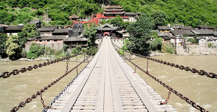
Photo adjustments
Full frame retained; proportionally resized and converted to WebP. No retouching or changes to the photographed subject. Card displays may crop the view.
- Administrative area
- County · 县
- Part of
- Garzê Tibetan Autonomous Prefecture
- Chinese name
- 泸定县
- Local areas
- County guide
Area & population
- Area in the source
- 2,165.35 km²
- Population · 2022
- 86,234
- Administrative seat
- Luqiao
Source: cited geographic source, as of the dates shown.
Bridge and old towns
Luding Bridge (泸定桥), in the county seat, uses thirteen iron chains. It forms part of the county’s Long March heritage, alongside the Red Army’s bridge-capture monument. Lan’an (岚安), Hualin (化林) and Lengqi (冷碛) are three old towns associated with the Sichuan–Tibet Tea Horse Road (川藏茶马古道).
Gongga’s eastern slopes
West of the river, Hailuogou (海螺沟), Yanzigou (燕子沟) and Yajiageng (雅家埂) lie on the eastern slopes of Mount Gongga (贡嘎山). This area combines glaciers, lakes, snowy peaks, forests and hot springs. Moxi Ancient Town (磨西古镇) adds a settlement to that mountain landscape. The county seat stands at 1,321 metres, while many surrounding peaks exceed 4,000 metres.
Sources for this guide
泸定简介 - 泸定县人民政府 · Luding County Government
泸定 | 一个离都市很近 离尘世很远的地方 - 泸定县人民政府 · Luding County Government
Original English written from the listed sources and checked sentence by sentence against quoted extracts by a separate reviewer. Updated 2026-09-27.
Explore Luding County
Core places to explore, with English and Chinese names.
Places to explore around Luding County
The deck of Luding Bridge across the Dadu River, photographed in 2007 · 泸定桥 Photograph date recorded by the source: 26 June 2007, 03:44.Luding Bridge泸定桥
Luding Bridge crosses the Dadu River on iron chains carrying a wooden deck. Nine chains support the deck and four form the side rails, so the structure is easy to understand from the riverbank before stepping onto it. Qing-style…
Read the place guide →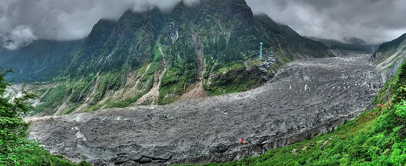 Hailuogou glacier and its mountain valley. Photograph date recorded by the source: 2010-07-06.
Hailuogou海螺沟
Hailuogou is the glacier-and-forest landscape on the eastern side of Mount Gongga, approached from Moxi. Its visitor route combines scenic buses, forest viewpoints and the cable-car area at Camp Four, now also called Gongga…
Read the place guide →Plan your visit
Getting there
Luding County is about 30 km in a straight line from central Garzê Tibetan Autonomous Prefecture. Search for 泸定县 in a map app to find stations and your accommodation.
Where to stay →Build your route
Luding Bridge and Hailuogou are about 45 km apart in a straight line. The linked place guides have entrance and visit details.
Continue with Garzê Tibetan Autonomous Prefecture →More in Garzê Tibetan Autonomous Prefecture
Sources & geographic information
Administrative names and parent areas: Official geographic directory · Reference date 2026-09-06.
Photo: Luding Bridge · gill_penney · CC BY 2.0. Full frame retained; proportionally resized and converted to WebP. No retouching or changes to the photographed subject. Card displays may crop the view.

Photo: Hailuogou · Oliver Ren · CC BY-SA 3.0. Full frame retained; proportionally resized and converted to WebP. No retouching or changes to the photographed subject. Card displays may crop the view.

Map data © OpenStreetMap contributors. Pins mark approximate centres, not entrances or boundaries.