


Get to know Litang County
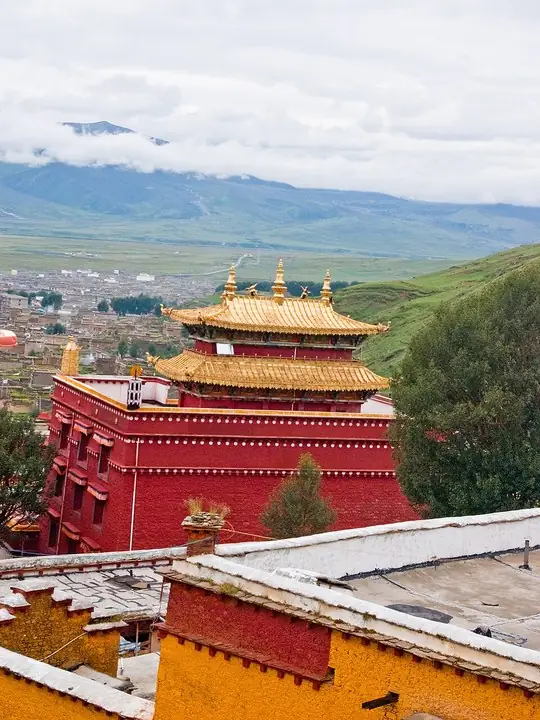
Photo adjustments
The exact downloaded source bytes are separately retained and hashed. Prepared JPEG is proportionally reduced to a maximum 720-pixel long edge; full frame retained, no subject alteration. Final website rendition: full frame retained, proportionally resized to at most 720 pixels and converted to WebP. No additional retouching or subject alteration. Card displays may crop the view.
- Administrative area
- County · 县
- Part of
- Garzê Tibetan Autonomous Prefecture
- Chinese name
- 理塘县
- Local areas
- County guide
Area & population
- Area in the source
- 13,677.00 km²
- Population · 2020
- 67,293
- Administrative seat
- Tochong (Litang)
Source: cited geographic source, as of the dates shown.
Setting and landscape
The county sits on the south-eastern edge of the Tibetan Plateau between the Jinsha (金沙江) and Yalong (雅砻江) rivers, and its waters drain to both. The Shaluli Mountains (沙鲁里山) run through it from north to south, and the land is mostly rolling plateau, higher in the west than in the east. The county town lies on open grassland ringed by snow peaks.
Mount Genie (格聂山), the highest peak of the Shaluli range, was measured at 6,174.5 metres in figures published by the Ministry of Natural Resources in 2023; a Japanese team first reached its summit in 1987. The county government lists it among Litang's leading tourism resources, together with the Maoya grassland (毛垭大草原), where a China News Service photographer recorded the Wuliang River (无量河) winding across the pasture and National Highway 318 running through it.
History and culture
The county government describes Litang as a trading town on the Tea Horse Road (茶马古道) and one of China's 120 purely pastoral counties. The former name was Lihua County (理化县), when it belonged to Xikang Province (西康省).
Litang Monastery (理塘寺), also known as Changqing Chunke'er Monastery (长青春科尔寺), is described by Chinese Wikipedia as the largest Gelug monastery in Kham. Building began in 1581, in the time of the Third Dalai Lama. The monastery was bombed and destroyed in March 1956 and rebuilt from 1982; it was added to the provincial heritage list in 2004 and listed as a national key cultural relic protection unit on 5 March 2013. Chinese Wikipedia also calls it the only Gelug monastery in Kham able to award the geshe degree.
Getting oriented
Litang lies at a crossroads between Sichuan, Yunnan, Tibet and Qinghai, and National Highways G318 and G227 cross the county. Its neighbours are Yajiang (雅江县) to the east, Batang (巴塘县) to the west, Baiyu (白玉县) and Xinlong (新龙县) to the north, and Muli (木里县), Daocheng (稻城县) and Xiangcheng (乡城县) to the south.
Highlights
- Litang Monastery 长青春科尔寺: Gelug monastery founded in 1581, a national key cultural relic protection unit since 2013.
- Mount Genie 格聂山: Highest peak of the Shaluli Mountains at 6,174.5 metres.
- Maoya grassland 毛垭大草原: Grassland crossed by the Wuliang River and National Highway 318.
- Thousand-household Tibetan village 千户藏寨: Listed by the county government among Litang's leading tourism resources.
Sources for this guide
理塘简介 - 理塘县人民政府 · Litang County People's Government
理塘县地理位置 - 理塘县人民政府 · Litang County People's Government
人间仙境-理塘格聂 - 理塘县人民政府 · Litang County Culture, Radio, Television and Tourism Bureau
国道318川藏线川西高原景观:美丽的毛垭草原 - 理塘县人民政府 · China News Service, republished by the Litang County People's Government
理塘县 - 维基百科,自由的百科全书 · Wikipedia (Chinese) · CC BY-SA 4.0
长青春科尔寺 - 维基百科,自由的百科全书 · Wikipedia (Chinese) · CC BY-SA 4.0
格聂峰 - 维基百科,自由的百科全书 · Wikipedia (Chinese) · CC BY-SA 4.0
Original English written from the listed sources and checked sentence by sentence against quoted extracts by a separate reviewer. Updated 2026-09-25.
Explore Litang County
Core places to explore, with English and Chinese names.
Places to explore around Litang County
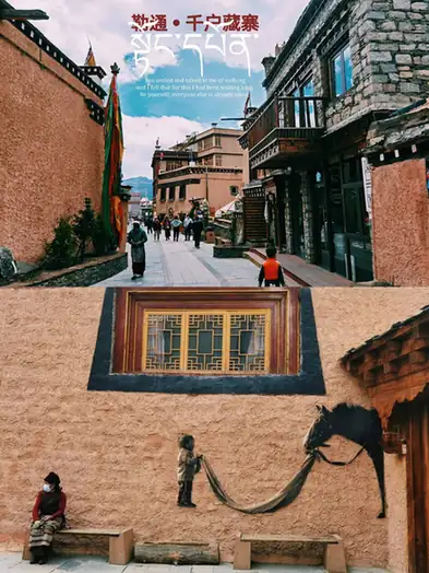 Letong Old Town and Thousand-Household Tibetan Village · 勒通古镇·千户藏寨
Letong Old Town and Thousand-Household Tibetan Village勒通古镇·千户藏寨
Letong Old Town and the Thousand-Household Tibetan Village form a scenic area north of the Litang county town in Garze Tibetan Autonomous Prefecture, Sichuan, made up of 13 Tibetan villages and more than 4,000 Tibetan houses; Letong is the Tibetan name of Litang itself.
Read the place guide → AI illustration · AI 示意图(仅供参考,非该地点实拍)
Mount Genie Official Viewing Trails格聂山正规开放观景线路
Genie is the main peak of the Shaluli range, 6,204 metres high, standing in Reke township in the south-west of Litang County, Garze Tibetan Autonomous Prefecture, Sichuan, at the centre of a scenic area that runs into Batang County and adjoins Xiangcheng and Daocheng.
Read the place guide →Golden-roofed hall of Litang Monastery · 长青春科尔寺金顶殿宇 Photograph date recorded by the source: 2009.Litang Monastery长青春科尔寺
Litang Monastery, also called Changqingchun Ke’er Temple, spreads across the northern hillside of Litang. Its large temple halls and tiered setting make it more than a single shrine. Much of the visible complex has been…
Read the place guide →Plan your visit
Getting there
Litang County is about 165 km in a straight line from central Garzê Tibetan Autonomous Prefecture. Search for 理塘县 in a map app to find stations and your accommodation.
Where to stay →Build your route
Letong Old Town and Thousand-Household Tibetan Village and Mount Genie Official Viewing Trails are both listed here. The linked place guides have entrance and visit details.
Continue with Garzê Tibetan Autonomous Prefecture →More in Garzê Tibetan Autonomous Prefecture
Sources & geographic information
Administrative names and parent areas: Official geographic directory (dmfw.mca.gov.cn) · Reference date 2026-09-06.
Some facts checked against 理塘县 — Wikipedia contributors, CC BY-SA 4.0.
Some facts checked against 长青春科尔寺 — Wikipedia contributors, CC BY-SA 4.0.
Some facts checked against 格聂峰 — Wikipedia contributors, CC BY-SA 4.0.
Photo: Letong Old Town and Thousand-Household Tibetan Village · Source photographer · License not provided. EXIF orientation normalized; resized without changing aspect ratio; converted to WebP. No subject edits.
Photo: Litang Monastery · Antoine Taveneaux · Antoine Taveneaux — Litang4.jpg — CC BY-SA 3.0 · CC BY-SA 3.0. The exact downloaded source bytes are separately retained and hashed. Prepared JPEG is proportionally reduced to a maximum 720-pixel long edge; full frame retained, no subject alteration. Final website rendition: full frame retained, proportionally resized to at most 720 pixels and converted to WebP. No additional retouching or subject alteration. Card displays may crop the view.

Map data © OpenStreetMap contributors. Pins mark approximate centres, not entrances or boundaries.