


Get to know Chenggong Township
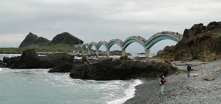
Photo adjustments
Full-frame source proportionally resized and converted to WebP for display. No subject alteration. Source-supplied marks and edits remain; cards may crop the view.
- Administrative area
- Township · 鎮
- Part of
- Taitung County
- Chinese name
- 成功鎮
- Local areas
- Township guide
Area & population
- Area in the source
- 144.00 km²
Source: cited geographic source, as of the dates shown.
Setting and landscape
Sanxiantai consists of an offshore island and coral-reef coast. The island was formerly a headland whose narrow neck was cut through by marine erosion. Its volcanic agglomerate supports sea stacks, while uplifted coral reefs occur around it. A shingle beach lies north of the headland, and waves make the stones resound as they wash across it.
What to see
The Marine Environmental Classroom (海洋環境教室), beside Xingang Fishing Harbour, introduces whales and dolphins commonly found off the east coast. Displays also explain the process and equipment used to harpoon billfish. An outdoor harpooning platform lets visitors simulate that fishing practice, connecting the exhibit to Chenggong's working maritime culture.
Sources for this guide
三仙台-東部海岸國家風景區觀光資訊網 · East Coast National Scenic Area Administration
成功漫遊-東部海岸國家風景區觀光資訊網 · East Coast National Scenic Area Administration
Original English written from the listed sources and checked sentence by sentence against quoted extracts by a separate reviewer. Updated 2026-09-27.
Explore Chenggong Township
Core places to explore, with English and Chinese names.
Places to explore around Chenggong Township
Plan your visit
Getting there
Chenggong Township is about 45 km in a straight line from central Taitung County. Search for 成功鎮 in a map app to find stations and your accommodation.
Where to stay →Build your route
Start with Sanxiantai. The linked place guides have entrance and visit details.
Continue with Taitung County →More in Taitung County
Sources & geographic information
Administrative names and parent areas: Official geographic directory · Reference date 2026-09-06.
Photo: Sanxiantai · Bernard Gagnon · CC BY-SA 3.0. Full-frame source proportionally resized and converted to WebP for display. No subject alteration. Source-supplied marks and edits remain; cards may crop the view.

Map data © OpenStreetMap contributors. Pins mark approximate centres, not entrances or boundaries.