


Get to know Tekes County
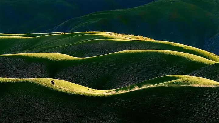
Photo adjustments
Full frame retained; resized proportionally to a maximum dimension of 960 pixels and converted to WebP quality 88. No crop, retouch, generated elements, or subject alteration. Final website rendition: full frame retained, proportionally resized to at most 720 pixels and converted to WebP. No additional retouching or subject alteration. Card displays may crop the view.
- Administrative area
- County · 县
- Part of
- Ili Kazakh Autonomous Prefecture
- Chinese name
- 特克斯县
- Local areas
- County guide
Area & population
- Area in the source
- 8,066.45 km²
- Population · 2020
- 148,945
- Administrative seat
- Tekes Town
Source: cited geographic source, as of the dates shown.
Setting and landscape
Mountains ring the county on all sides, and hills and mountains make up 93 percent of it. The main ridge of the Tianshan (天山) to the south reaches 4,902 metres and the Wusun Mountains (乌孙山) to the north 3,500 metres, while the county town stands at 900 to 1,200 metres. Eighteen rivers flow through the county, and the Tekes River joins the Künes (巩乃斯河) and Kax (喀什河) rivers to form the Ili. Annual precipitation is 441.1 millimetres.
History
Tekes became a county on 1 March 1937, seated at Kebu (科布), a cramped site between river and mountain. Qiu Zongjun (邱宗浚), father-in-law of Sheng Shicai (盛世才), had a new town planned on the eight trigrams of the Book of Changes (周易), with four rings of streets and 64 streets in all. In summer 1939 twenty ox-drawn ploughs marked out its eight radial streets, and on 22 October that year the county government moved in. A story credits the Taoist master Qiu Chuji (丘处机) with the plan, but the account of his journey west, the Changchun Zhenren Xiyouji (长春真人西游记), shows he never reached the Tekes River. The county was renamed Kizilkura (克孜勒库热县) in January 1945 and took back the name Tekes on 19 December 1951. The State Council listed the town as a national historic and cultural city in 2007.
What to see
Qiongkushitai (琼库什台), in Karadala (喀拉达拉镇) town, is a Chinese historic and cultural village of wooden buildings set among forest and grassland. The hill behind the village and the Wusun Ancient Road (乌孙古道) are well-known local photo spots. Felt-tent home visits were the village's most popular activity in 2025, according to a homestay manager quoted by the county government: visitors go into herders' homes to milk cows, drink milk tea, help bake naan (馕) and make butter.
Kalajun Lake (喀拉峻湖) is in the county; in mid-December, after snow, its shore turns white and thin ice on the water forms "frost flowers".
Highlights
- Tekes Bagua town 特克斯八卦城: County town laid out on the eight trigrams in 1939; a national historic and cultural city since 2007.
- Qiongkushitai village 琼库什台村: A Chinese historic and cultural village of wooden buildings among forest and grassland.
- Wusun Ancient Road 乌孙古道: Named with the hill behind Qiongkushitai as one of the village's well-known photo spots.
- Kalajun Lake 喀拉峻湖: A lake in the county where thin ice forms "frost flowers" in mid-December.
Sources for this guide
地理环境_ 地理环境_ 特克斯县人民政府 · Tekes County People's Government
历史沿革_ 历史沿革_ 特克斯县人民政府 · Tekes County People's Government
特克斯县琼库什台村:多元业态绽放,绘就乡村旅游新图景_ 风光名胜_ 特克斯县人民政府 · Tekes County People's Government
【图说新疆】新疆特克斯:喀拉峻湖“结”霜花_ 风光名胜_ 特克斯县人民政府 · Tekes County People's Government
特克斯县 - 维基百科,自由的百科全书 · Wikipedia · CC BY-SA 4.0
Original English written from the listed sources and checked sentence by sentence against quoted extracts by a separate reviewer. Updated 2026-09-25.
Explore Tekes County
Core places to explore, with English and Chinese names.
Places to explore around Tekes County
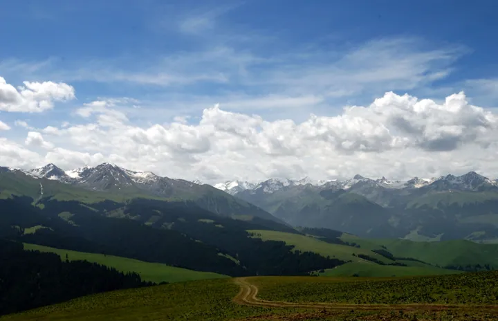 Rolling grassland and snow-capped peaks at the Kalajun grassland, Tekes County · 伊犁哈萨克自治州特克斯县喀拉峻草原及雪山 Source-recorded photograph date: 2009-07-03 13:15.
Kalajun Grassland喀拉峻
Kalajun (喀拉峻) is an international eco-tourism area in Tekes County (特克斯县), Ili Kazakh Autonomous Prefecture, Xinjiang, on the northern slopes of the Biyike mountain in the central Tianshan. The county government records that it is a world natural heritage site and a national AAAAA-level tourist attraction, and that the name means "black wilderness" in Kazakh.
Read the place guide → An elevated view over the centre of Tekes: a paved roundabout with a red-pillared paifang on its garden island, straight tree-lined avenues radiating away between low white-tiled commercial blocks, and a low brown mountain range along the horizon under a pale sky.
Tekes Bagua City特克斯八卦城
Tekes Bagua City (特克斯八卦城) is the county town of Tekes County (特克斯县), Ili Kazakh Autonomous Prefecture, Xinjiang, laid out on the eight trigrams of the Yijing. The county government records that it was approved by the State Council as a national historical and cultural city in 2007 and rated a national AAAA-level tourist attraction in November 2020.
Read the place guide → Qiongkushitai Village · 琼库什台
Qiongkushitai Village琼库什台
Qiongkushitai (琼库什台) is a village in the southern hills of Tekes County (特克斯县), Ili Kazakh Autonomous Prefecture, Xinjiang, at the northern entrance of the Wusun ancient road. The county government records that it was named a Chinese historical and cultural village in December 2010, and the village lies across the river from the Kalajun grassland.
Read the place guide → AI illustration · AI 示意图(仅供参考,非该地点实拍)
Kuokesu Grand Canyon阔克苏大峡谷
Kuoksu Grand Canyon (阔克苏大峡谷) is a canyon in the south of Tekes County (特克斯县), Ili Kazakh Autonomous Prefecture, Xinjiang. China Daily records that it was formed by geological movement and meltwater erosion in the central Tianshan and that it is a core component of the Kalajun world natural heritage scenic area.
Read the place guide →Plan your visit
Getting there
Tekes County is about 90 km in a straight line from central Ili Kazakh Autonomous Prefecture. Search for 特克斯县 in a map app to find stations and your accommodation.
Where to stay →Build your route
Kalajun Grassland and Tekes Bagua City are both listed here. The linked place guides have entrance and visit details.
Continue with Ili Kazakh Autonomous Prefecture →More in Ili Kazakh Autonomous Prefecture
Sources & geographic information
Administrative names and parent areas: Official geographic directory · Reference date 2026-09-06.
Some facts checked against 特克斯县 — Wikipedia contributors, CC BY-SA 4.0.
Photo: Kalajun Grassland · lwtt93 from Shanghai, China · CC BY 2.0. Full frame retained; proportionally resized and converted to WebP. No retouching or changes to the photographed subject. Card displays may crop the view.
.jpg)
Photo: Tekes Bagua City · Nyx Ning · CC BY-SA 3.0. Full frame retained; proportionally resized and converted to WebP. No retouching or changes to the photographed subject. Card displays may crop the view.

Photo: Qiongkushitai Village · Source photographer · License not provided. EXIF orientation normalized; resized without changing aspect ratio; converted to WebP. No subject edits.
Map data © OpenStreetMap contributors. Pins mark approximate centres, not entrances or boundaries.