


Get to know Huocheng County

Photo adjustments
Full frame retained; proportionally resized and converted to WebP. No retouching or changes to the photographed subject. Card displays may crop the view.
- Administrative area
- County · 县
- Part of
- Ili Kazakh Autonomous Prefecture
- Chinese name
- 霍城县
- Local areas
- County guide
Area & population
- Population · 2020
- 243,303
- Administrative seat
- Shuiding
Source: cited geographic source, as of the dates shown.
Setting and landscape
The Kegurqin Mountains (科古尔琴山), a branch of the Tianshan, form the northern edge of the county, and the Ili River (伊犁河) runs along the south, with Qapqal (察布查尔) county across the water. The Guozigou valley (果子沟) is the gateway into and out of the Ili valley. The county has a nature reserve for the Russian tortoise (四爪陆龟), a nationally protected first-class species, and wild red deer, gazelles (黄羊) and leopards live here.
History
The county government describes Huocheng as a stronghold on the northern route of the Silk Road and the site of the capital of the Chagatai Khanate (察合台汗国). Five of the Qing dynasty's "nine cities of Ili" stood here. In 1914 the Republic turned the Khorgas frontier post into Khorgas County, seated at Gongchen (拱宸城); in 1947 it was renamed Huocheng County. In 1966 Shuiding County was merged into Huocheng and the county government was placed at Shuiding (水定镇); in 2014 a Xibe township, a pasture, two Corps regiments and the Khorgas port passed to the new city of Khorgas.
What to see
Huiyuan (惠远城) on the north bank of the Ili River was the seat of the Ili general and, before Xinjiang became a province, the Qing military and political centre of the region. Proposed in 1763 and largely complete by 1765, its name means the emperor's favour reaching far places. Rebels took it in 1866; after Ili returned to Qing rule, a new town was begun in 1882 north of the old one, which the river has since badly eroded. The old and new town sites are both national key cultural relics protection units; the Ili General's Office (伊犁将军府) and the Huiyuan bell and drum tower (惠远钟鼓楼) stand inside the new town, and Huiyuan is a national 4A scenic area.
The county's other 4A scenic areas are the Fushou Mountain (中华福寿山), the Jieyou Princess Lavender Garden (解忧公主薰衣草园), the Tukai Desert (图开沙漠), about 5 kilometres west of Huiyuan, and the Guozigou-Sayram Lake area (果子沟-赛里木湖景区). Lavender flowers in the fields beside the roads from June to August.
Food and local products
Huocheng lavender, tree-dried apricots (树上干杏), wild cherry plums (野生樱桃李) and Huiyuan carrots (惠远胡萝卜) are national geographical-indication farm products, and the county is also called China's home of wild cherry plums.
Getting oriented
Central Yining lies about 45 kilometres to the east. The Lianyungang-Khorgas and Qingshuihe-Yining expressways and National Highways 312 and 218 meet in the county, and the Jinghe-Yining-Khorgas railway (精伊霍铁路) crosses the county.
Highlights
- Huiyuan ancient city 惠远古城: Seat of the Qing Ili general; the old and new town sites are national key cultural relics protection units and a 4A scenic area.
- Ili General's Office 伊犁将军府: A national key cultural relics protection unit inside Huiyuan new town.
- Guozigou 果子沟: The gateway valley into the Ili valley; part of the Guozigou-Sayram Lake 4A scenic area.
- Jieyou Princess Lavender Garden 解忧公主薰衣草园: A national 4A scenic area in the county the government calls China's home of lavender.
- Tukai Desert 图开沙漠: A 4A scenic area about 5 km west of Huiyuan.
Sources for this guide
霍城概况 · Huocheng County People's Government
霍城县 - 维基百科,自由的百科全书 · Wikipedia · CC BY-SA 4.0
惠远城 - 维基百科,自由的百科全书 · Wikipedia · CC BY-SA 4.0
Original English written from the listed sources and checked sentence by sentence against quoted extracts by a separate reviewer. Updated 2026-09-25.
Explore Huocheng County
Core places to explore, with English and Chinese names.
Places to explore around Huocheng County
 The east gate of the old city wall at Huiyuan Ancient City ruins, Huocheng County · 伊犁哈萨克自治州霍城县惠远古城遗址东门 Source-recorded photograph date: 2025-10-14 12:46:29.
Huiyuan Ancient City惠远古城
Huiyuan (惠远古城) is a Qing-era walled town in Huocheng County (霍城县), Ili Kazakh Autonomous Prefecture, Xinjiang, on the north bank of the Ili river. The county government records that its old city was first built in 1763 and that until 1884 Huiyuan was the political and military centre of Xinjiang and the first of the nine Ili cities; the prefecture government records that the Ili General's Office there was listed as a national key cultural relic protection unit in 1996.
Read the place guide → Guozigou Valley Official Viewpoint · 果子沟正规观景点
Guozigou Valley Official Viewpoint果子沟正规观景点
Guozigou (果子沟) is a gorge running the length of the northern Tianshan in Huocheng County (霍城县), Ili Kazakh Autonomous Prefecture, Xinjiang. The county and prefecture governments both record it as a long-standing landmark of Xinjiang, and Xinhua records that the Guozigou section of the Lianhuo expressway crosses the Tianshan mountains, and that the Lianhuo expressway bridge merges into the natural landscape.
Read the place guide →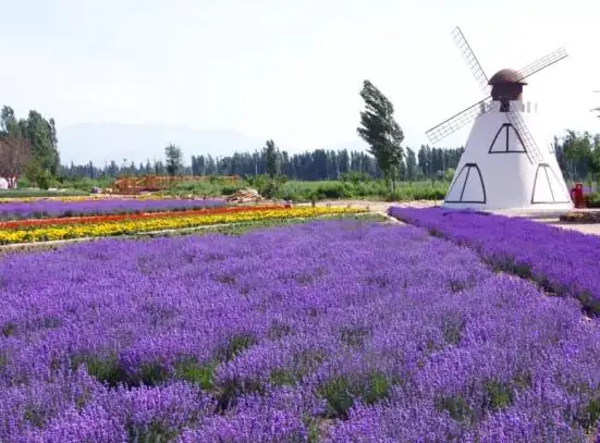 Princess Jieyou Lavender Garden · 解忧公主薰衣草园
Princess Jieyou Lavender Garden解忧公主薰衣草园
Jieyou Gongzhu Lavender Park (解忧公主薰衣草园) is a lavender growing and processing park at Qingshuihe town (清水河镇), Huocheng County (霍城县), Ili Kazakh Autonomous Prefecture, Xinjiang, on the northern foot of the Tianshan in the Ili river valley. The county government records it as a national AAAA-level tourist attraction, and the county tourism bureau records that its rebuilt industry park was put fully into use on 1 June 2024.
Read the place guide →Plan your visit
Getting there
Huocheng County is about 40 km in a straight line from central Ili Kazakh Autonomous Prefecture. Search for 霍城县 in a map app to find stations and your accommodation.
Where to stay →Build your route
Huiyuan Ancient City and Guozigou Valley Official Viewpoint are both listed here. The linked place guides have entrance and visit details.
Continue with Ili Kazakh Autonomous Prefecture →More in Ili Kazakh Autonomous Prefecture
Sources & geographic information
Administrative names and parent areas: Official geographic directory · Reference date 2026-09-06.
Some facts checked against 霍城县 — Wikipedia contributors, CC BY-SA 4.0.
Some facts checked against 惠远城 — Wikipedia contributors, CC BY-SA 4.0.
Photo: Huiyuan Ancient City · HaziiDozen · CC BY-SA 4.0. Full frame retained; proportionally resized and converted to WebP. No retouching or changes to the photographed subject. Card displays may crop the view.

Photo: Guozigou Valley Official Viewpoint · Source photographer · License not provided. EXIF orientation normalized; resized without changing aspect ratio; converted to WebP. No subject edits.
Photo: Princess Jieyou Lavender Garden · Source photographer · License not provided. EXIF orientation normalized; resized without changing aspect ratio; converted to WebP. No subject edits.
Map data © OpenStreetMap contributors. Pins mark approximate centres, not entrances or boundaries.