


Get to know Xiangyun County
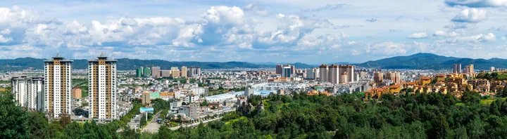
Photo adjustments
Full frame retained; proportionally resized and converted to WebP. No retouching or changes to the photographed subject. Card displays may crop the view.
- Administrative area
- County · 县
- Part of
- Dali Bai Autonomous Prefecture
- Chinese name
- 祥云县
- Local areas
- County guide
Area & population
- Area in the source
- 2,498.00 km²
- Population · 2020 census
- 406,642
Source: cited geographic source, as of the dates shown.
An old name and wartime routes
The settlement takes its name from the post station maintained here during the Yuan, Ming and Qing dynasties. Its history also reaches back to Han-period Yunnan County and the Yunnan Commandery of the Wei and Jin periods. During the Second World War, the Hump air route, Burma Road and China–India oil pipeline converged here alongside the older post road.
Temples, stupas and flowering trees
Shuimu Mountain (水目山) is associated with Buddhist temples and a concentration of stupas. Shuimu Temple (水目寺) became an important Chan Buddhist centre during the Dali Kingdom period. The mountain’s vegetation includes oaks, camphor trees, lindens and cypresses. Old roses flower through the year, and the cultivated Yunnan camellia known as Lion’s Head (狮子头) is another locally noted plant.
Sources for this guide
云南驿 - 祥云县人民政府 · Xiangyun County Government
水目山 - 祥云县人民政府 · Xiangyun County Government
Original English written from the listed sources and checked sentence by sentence against quoted extracts by a separate reviewer. Updated 2026-09-27.
Explore Xiangyun County
Core places to explore, with English and Chinese names.
Xiangyun County 祥云县
Plan your visit
Getting there
Xiangyun County is about 30 km in a straight line from central Dali Bai Autonomous Prefecture. Search for 祥云县 in a map app to find stations and your accommodation.
Where to stay →More in Dali Bai Autonomous Prefecture
Sources & geographic information
Administrative names and parent areas: Official geographic directory · Reference date 2026-09-06.
Map data © OpenStreetMap contributors. Pins mark approximate centres, not entrances or boundaries.