


Get to know Weishan Yi and Hui Autonomous County

Photo adjustments
Full frame retained; proportionally resized and converted to WebP. No retouching or changes to the photographed subject. Card displays may crop the view.
- Administrative area
- Autonomous county · 自治县
- Part of
- Dali Bai Autonomous Prefecture
- Chinese name
- 巍山彝族回族自治县
- Local areas
- Autonomous county guide
Area & population
- Area in the source
- 2,200.00 km²
- Population · 2020 census
- 267,474
- Administrative seat
- Nanzhao
Source: cited geographic source, as of the dates shown.
Setting and landscape
The northern Ailao range forms the east of the county and the northern Wuliang range its centre, with the Weishan basin between them. The Wuliang is the watershed: the west drains to the Yangbi River (漾濞江) and the Mekong system, the east to the Yuan River (元江), the upper Red River, whose source lies in Yongjian (永建镇) in the north-west of the county. The county town stands at 1,725 metres.
History
Nanzhao was founded here in the Tang and had its early capital in the area. The Yuan made it Menghua prefecture (蒙化府) in 1274, and the name Menghua lasted until the county was renamed Weishan in 1954. In 1956 the county was split into a Yi autonomous county and the Yongjian Hui autonomous county (永建回族自治县), which merged in 1958 to form the present Yi and Hui county. Weishan was named a national historic and cultural city in 1994.
What to see
Weishan Old Town (巍山古城), the county seat at Nanzhao Town (南诏镇), was built in the early Ming on a square chessboard plan, and most of its houses keep their Ming and Qing appearance. Its Nanzhao Street (南诏古街) was named a famous historic street of China in 2011, and the Nanzhao Town building group, which includes the Yuhuang Pavilion (玉皇阁), Wenhua Academy (文华书院) and Xiaogong Shrine (萧公祠), is a national protected site together with Dengjue Temple (等觉寺). Gongchen Tower (拱辰楼), over the north gate, was destroyed by fire on 3 January 2015. Southeast of town, Weibao Mountain is a Taoist mountain with 22 Ming and Qing temples; its Changchun Cave (长春洞) is a national protected site, and the mountain became a national forest park in 1992. The Nanzhao Tuzhu Temple (南诏土主庙) on the mountain is an important Yi ancestral shrine; since a 2007 ceremony there, the county has made the first half of the second lunar month a yearly Yi ancestor festival.
Food and local products
Weishan braised-pork rice noodles (巍山扒肉饵丝) start many local mornings, according to the Dali prefecture government: pork hind leg, hock and belly are charcoal-roasted, scraped and stewed until tender, and the noodles, made from the local huanggu rice (黄谷米), are softened in boiling water and served with a ladle of the broth. Weishan tie-dye (扎染) was first shown at the Beijing international trade fair in 1985, and in 2003 the Ministry of Culture named Weishan a home of Chinese folk tie-dye art.
Highlights
- Weishan Old Town 巍山古城: Early-Ming town on a square chessboard plan with Ming and Qing houses.
- Weibao Mountain 巍宝山: Taoist mountain with 22 Ming and Qing temples; national forest park since 1992.
- Changchun Cave 长春洞: Taoist temple on Weibao Mountain listed as a national protected site.
- Dengjue Temple 等觉寺: National protected site in the old town.
- Weishan braised-pork rice noodles 巍山扒肉饵丝: Charcoal-roasted, stewed pork with huanggu rice noodles in broth.
- Weishan tie-dye 巍山扎染: Folk craft; Weishan named a home of Chinese folk tie-dye art in 2003.
Sources for this guide
巍山彝族回族自治县 - 维基百科,自由的百科全书 · Chinese Wikipedia · CC BY-SA 4.0
大理这些“舌尖上的非遗”,你吃过多少? - 大理白族自治州人民政府 · Dali Bai Autonomous Prefecture People's Government
Original English written from the listed sources and checked sentence by sentence against quoted extracts by a separate reviewer. Updated 2026-09-25.
Explore Weishan Yi and Hui Autonomous County
Core places to explore, with English and Chinese names.
Places to explore around Weishan Yi and Hui Autonomous County
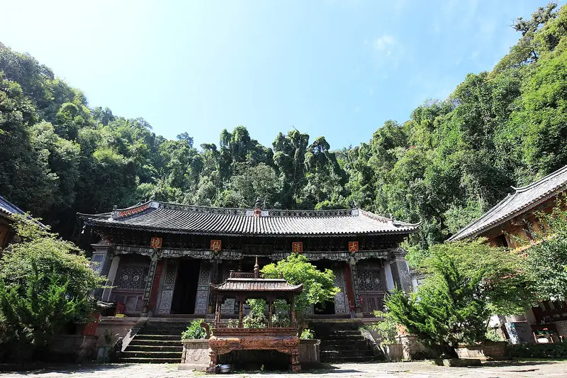 Weibao Mountain (巍宝山), Weishan Yi and Hui Autonomous County. Photograph: "Qingxia Taoist Temple of Weibao Mountain".
Weibao Mountain巍宝山
Daoist mountain south of Weishan, cradle of the Nanzhao kingdom, with Qing temples in forest and the nationally listed Changchun Cave.
Read the place guide →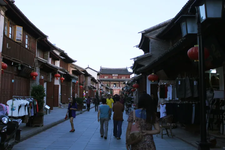 Ri Sheng Road inside Weishan Old Town, Dali · 大理州巍山彝族回族自治县巍山古城日昇路 Source-recorded photograph date: 2013-06-12 20:21:51.
Weishan Old Town巍山古城
Weishan’s old town keeps a street grid organised around substantial gateway and tower buildings. Gongchen Tower marks the northern approach, while Xinggong Tower stands over a four-way junction, with arched openings beneath its…
Read the place guide →Local life & food
Weishan Yi and Hui Autonomous County local specialties
巍山彝族回族自治县特色美食 · 1 specialties to discover
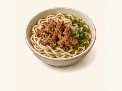 Weishan braised-pork rice noodles 巍山扒肉饵丝AI dish illustration / AI 菜品示意图
The noodles have a smooth, resilient bite against very soft meat. The broth carries the pork's richness through the bowl.
Source ↗Read the dish guide →All dish names · 全部菜名 (1)
More dishes from across Yunnan are in the Yunnan food guide.
Plan your visit
Getting there
Weishan Yi and Hui Autonomous County is about 45 km in a straight line from central Dali Bai Autonomous Prefecture. Search for 巍山彝族回族自治县 in a map app to find stations and your accommodation.
Where to stay →Build your route
Weibao Mountain and Weishan Old Town are both listed here. The linked place guides have entrance and visit details.
Continue with Dali Bai Autonomous Prefecture →More in Dali Bai Autonomous Prefecture
Sources & geographic information
Administrative names and parent areas: Official geographic directory · Reference date 2026-09-06.
Some facts checked against 巍山彝族回族自治县 — Wikipedia contributors, CC BY-SA 4.0.
Photo: Weibao Mountain · Xin · CC BY-SA 4.0. Full frame retained; EXIF orientation normalized, proportionally resized to at most 800 pixels and converted to WebP. No generated pixels or subject changes. Cards may crop the display.

Photo: Weishan Old Town · Zhangmoon618 · CC BY-SA 3.0. Full frame retained; proportionally resized and converted to WebP. No retouching or changes to the photographed subject. Card displays may crop the view.

Map data © OpenStreetMap contributors. Pins mark approximate centres, not entrances or boundaries.