


Get to know Dehong Dai and Jingpo Autonomous Prefecture

Photo adjustments
Full frame retained; proportionally resized and converted to WebP. No retouching or changes to the photographed subject. Card displays may crop the view.
- Administrative area
- Autonomous prefecture · 自治州
- Part of
- Yunnan
- Chinese name
- 德宏傣族景颇族自治州
- Local areas
- 5 local areas
Area & population
- Area in the source
- 11,172.24 km²
- Population · 2020 census
- 1,315,709
- Administrative seat
- Mangshi
Source: cited geographic source, as of the dates shown.
Explore Dehong Dai and Jingpo Autonomous Prefecture
Core places to explore, with English and Chinese names.
Nandian Tusi Chieftain's Office 南甸宣抚司署
Moli Tropical Rainforest 莫里热带雨林
One Village Two Countries 一寨两国
Wanding Bridge 畹町桥
Shiti Village Birdwatching Trail 石梯村正规观鸟线路
Tree-Wrapped Pagoda 树包塔
Mengbanaxi Rare Plant Garden 勐巴娜西珍奇园
Menghuan Golden Pagoda and Silver Pagoda 勐焕大金塔与银塔
Ruili 瑞丽市
Mangshi 芒市
Lianghe County 梁河县
Yingjiang County 盈江县
Longchuan County 陇川县
Places to explore around Dehong Dai and Jingpo Autonomous Prefecture
 The front gate of Nandian Tusi Chieftain's Office (Nandian Tusi Chiefdom Office) in Lianghe County, Dehong · 德宏州梁河县南甸宣抚司署大门 Source-recorded photograph date: 2024-05-29 09:21:12.
Nandian Tusi Chieftain's Office南甸宣抚司署
Yamen of the Dao-Gong chieftains in Lianghe, built 1851-1935 on a Han-style plan of 47 buildings, with Qing regalia and a tusi museum.
Read the place guide → Moli Tropical Rainforest (莫里热带雨林), Ruili. Photograph: "Moli Waterfall in Ruili".
Moli Tropical Rainforest莫里热带雨林
Moli Tropical Rainforest (莫里热带雨林) is a forested gorge 20 kilometres northeast of Ruili, Dehong Dai and Jingpo Autonomous Prefecture, Yunnan, centred on a 60-metre waterfall known locally as Zhaduo Falls.
Read the place guide →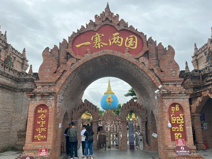 The main entrance arch of One Village Two Countries ("One Village, Two Countries"), Ruili, Dehong Prefecture · 德宏傣族景颇族自治州瑞丽市一寨两国景区正门 Source-recorded photograph date: 2023-07-06.
One Village Two Countries一寨两国
Dai village split by the China-Myanmar border at marker 71 near Ruili, with a well both sides share, a border swing and a cross-border school.
Read the place guide →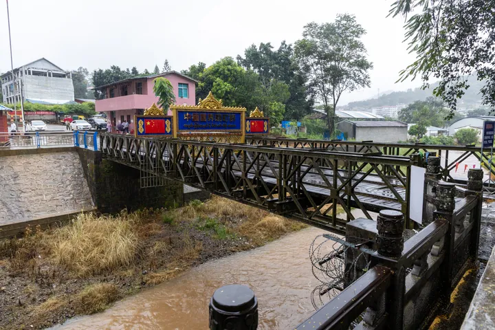 Wanding Bridge on the China-Myanmar border, Ruili · 中缅国界畹町桥,瑞丽市 Source-recorded photograph date: 2025-11-03 12:45:29.
Wanding Bridge畹町桥
Border bridge at Wanding in Ruili, end of the Burma Road's Chinese section; the steel span was built in 1945 and is a national protected site.
Read the place guide →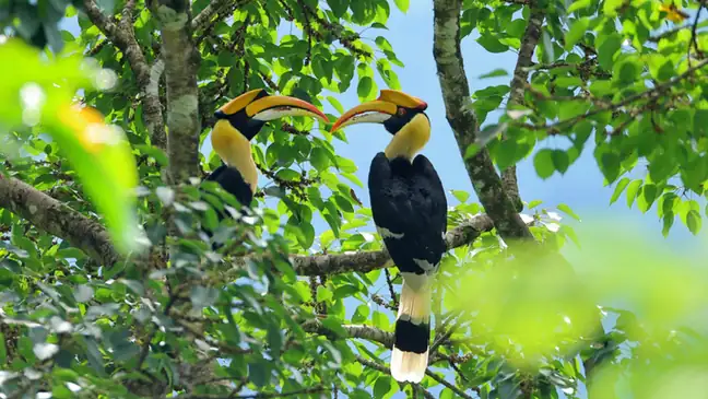 Shiti Village Birdwatching Trail · 石梯村正规观鸟线路
Shiti Village Birdwatching Trail石梯村正规观鸟线路
Shiti (石梯村) is a Jingpo and Lisu village on the China-Myanmar border in Taiping town, Yingjiang County, Dehong Dai and Jingpo Autonomous Prefecture, Yunnan, known for maintaining official birdwatching routes and hides through rainforest that supports three breeding hornbill species.
Read the place guide →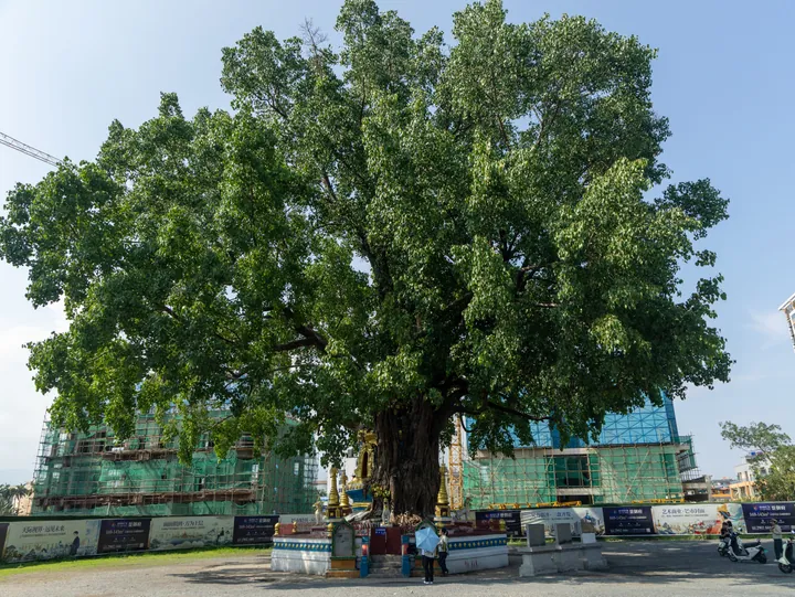 The banyan tree enveloping the stupa at Shubaota (Tree-Wrapped Stupa), Mangshi · 德宏傣族景颇族自治州芒市树包塔,古榕树包裹佛塔 Source-recorded photograph date: 2025-05-14 16:28:48.
Tree-Wrapped Pagoda树包塔
Shubaota (树包塔, 'the tree-wrapped pagoda') is a Buddhist pagoda in Mangshi, Dehong Dai and Jingpo Autonomous Prefecture, Yunnan, now largely enveloped by the roots and canopy of a banyan tree that took root in its brickwork.
Read the place guide →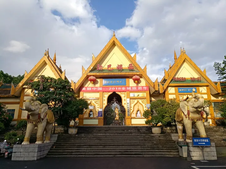 Main entrance of Mengbanaxi Park, Mangshi, Dehong · 德宏芒市勐巴娜西珍奇园正门 Source-recorded photograph date: 2018-06-22 19:05:49.
Mengbanaxi Rare Plant Garden勐巴娜西珍奇园
Garden in Mangshi, Dehong, with old trees, themed plant gardens, petrified wood and a 1956 Zhou Enlai memorial pavilion; a national 4A scenic area.
Read the place guide → Menghuan Golden Pagoda and Silver Pagoda · 勐焕大金塔与银塔
Menghuan Golden Pagoda and Silver Pagoda勐焕大金塔与银塔
Menghuan Golden Pagoda and Silver Pagoda (勐焕大金塔与银塔) are two large Buddhist pagodas on facing hills above Mangshi, Dehong Dai and Jingpo Autonomous Prefecture, Yunnan, standing about a kilometre apart.
Read the place guide →Local life & food
Dehong Dai and Jingpo Autonomous Prefecture local specialties
德宏傣族景颇族自治州特色美食 · 13 specialties to discover
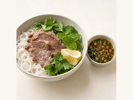 Dai-style lemon sa with rice noodles 傣味柠檬撒AI dish illustration / AI 菜品示意图
Expect a sharp citrus taste, fresh herbs and chilli, with soft noodles carrying the dressing. The mixture can be intense, so a little dip may season more noodles than its small bowl suggests.
Source ↗Read the dish guide → Hand-Held Rice Noodles 过手米线Reference photo of a similar dish · 同类菜品参考照片
Hand-Held Rice Noodles (过手米线) comes from Husa Achang Township (户撒阿昌族乡) in Longchuan County (陇川县), Dehong (德宏).
Read the dish guide →
Photo adjustments
Full frame retained; EXIF orientation normalized, proportionally resized to at most 800 pixels and converted to WebP. No generated pixels or subject changes. Cards may crop the display.
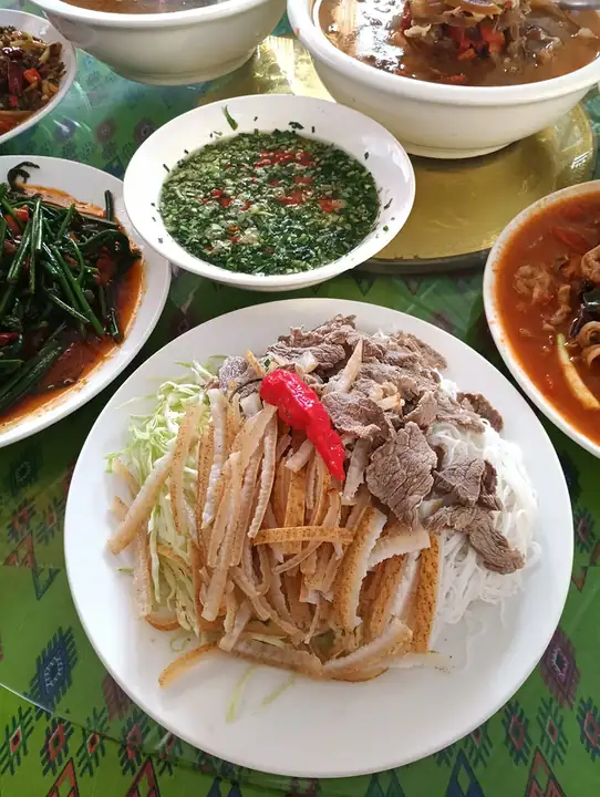 Sapie Cold Dish 撒撇
Sapie Cold Dish (撒撇) is a Dai (傣族) cold mixed dish of beef, eaten with a bitter or sour sauce. In Dai, "sapie" means a cold mixed dish, and "pie" usually refers to beef.
Read the dish guide →
Photo adjustments
EXIF orientation normalized; resized without changing aspect ratio; converted to WebP. No subject edits.
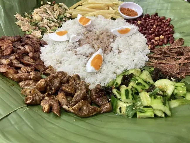 Dai-Style Rice Eaten by Hand 傣味手抓饭
Dai-Style Rice Eaten by Hand (傣味手抓饭) is listed among the local specialties of Xishuangbanna Dai Autonomous Prefecture, Yunnan. It is grouped here with rice & congee; retain the complete Chinese name when comparing local menus.
Read the dish guide →Photo adjustments
EXIF orientation normalized; resized without changing aspect ratio; converted to WebP. No subject edits.
 Jingpo shredded chicken salad 景颇鬼鸡AI illustration · AI 示意图
The chicken is tender, with a vivid sour-spicy finish and a strong herbal aroma. Unlike a braise, the dressing remains bright and fresh.
Source ↗Read the dish guide → Paluda coconut dessert drink 泡鲁达AI illustration · AI 示意图
The drink is sweet and coconut-rich, with chewy or slippery toppings and bread that changes from crunchy to soft as it soaks.
Source ↗Read the dish guide →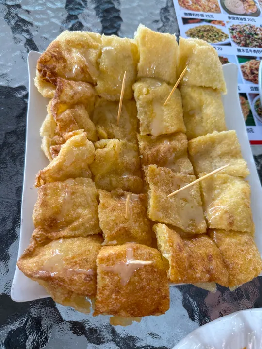 Burmese Tossed Flatbread 缅甸甩粑粑
Burmese Tossed Flatbread (缅甸甩粑粑) is one of the Burmese snacks sold in Dehong Dai and Jingpo Autonomous Prefecture (德宏傣族景颇族自治州), Yunnan.
Read the dish guide →
Photo adjustments
Full frame retained; proportionally resized and converted to WebP. No retouching or changes to the photographed subject. Card displays may crop the view.
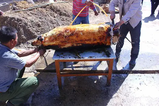 Yingjiang Dai Fire-Roasted Pig 火烧乳猪
Yingjiang Dai Fire-Roasted Pig (火烧乳猪) is a whole pig roasted over an open fire, a traditional dish of the Dai (傣族) people of Yingjiang County (盈江县) in Dehong Dai and Jingpo Autonomous Prefecture (德宏傣族景颇族自治州), Yunnan.
Read the dish guide →
Photo adjustments
EXIF orientation normalized; resized without changing aspect ratio; converted to WebP. No subject edits.
All dish names · 全部菜名 (13)
- Dai-style lemon sa with rice noodles · 傣味柠檬撒
- Hand-Held Rice Noodles · 过手米线
- Sapie Cold Dish · 撒撇
- Dai-Style Rice Eaten by Hand · 傣味手抓饭
- Jingpo shredded chicken salad · 景颇鬼鸡
- Paluda coconut dessert drink · 泡鲁达
- Burmese Tossed Flatbread · 缅甸甩粑粑
- Yingjiang Dai Fire-Roasted Pig · 火烧乳猪
- Bamboo Tube Rice · 竹筒饭
- Pounded Chicken Feet · 舂鸡脚
- Fish with Sour Bamboo Shoots · 酸笋鱼
- Bitter Beef Sa · 牛苦撒
- Pea Flour Porridge · 稀豆粉
More dishes from across Yunnan are in the Yunnan food guide.
Counties & districts in Dehong Dai and Jingpo Autonomous Prefecture
5 areas belong directly to Dehong Dai and Jingpo Autonomous Prefecture.
5 areas
Ruili 瑞丽市
Ruili (simplified Chinese: 瑞丽; traditional Chinese: 瑞麗; pinyin: Ruìlì; Tai Nüa: ᥛᥫᥒᥰ ᥛᥣᥝᥰ; Shan: မိူင်းမၢဝ်း; Thai: เมืองมาว; Burmese: ရွှေလီ), called Möng Mao in Tai, is a county-level city of Dehong…
Explore the area →County-level cityMangshi 芒市
Mangshi, former name Luxi (潞西), is a county-level city and the seat of Dehong Dai and Jingpo Autonomous Prefecture in western Yunnan province, China.
Explore the area →CountyLianghe County 梁河县
Lianghe County is located in Dehong Prefecture, Yunnan province, southwest China.
Explore the area →CountyYingjiang County 盈江县
Yingjiang County (simplified Chinese: 盈江县; traditional Chinese: 盈江縣; pinyin: Yíngjiāng Xiàn; Tai Nüa: ᥔᥦᥢᥱ ᥛᥫᥒᥰ ᥘᥣᥲ; Jingpho: Yinkyang Ginwang; Thai: เมืองหล้า) is a county in Dehong Prefecture, Yunnan…
Explore the area →No areas match this name.
Plan your visit
Getting there
Search for 德宏傣族景颇族自治州 in a map app to find stations and your accommodation.
Where to stay →Build your route
Nandian Tusi Chieftain's Office and Moli Tropical Rainforest are both listed here. The linked place guides have entrance and visit details.
Continue with Yunnan →More in Yunnan
Sources & geographic information
Administrative names and parent areas: Official geographic directory · Reference date 2026-09-06.
Background text adapted from Dehong Dai and Jingpo Autonomous Prefecture — Wikipedia contributors, under CC BY-SA 4.0. Text has been shortened and reorganized; source revision 1370826592.
Photo: Nandian Tusi Chieftain's Office · 瑞丽江的河水 · CC BY-SA 4.0. Full frame retained; proportionally resized and converted to WebP. No retouching or changes to the photographed subject. Card displays may crop the view.

Photo: Moli Tropical Rainforest · Doge24190 · CC BY 4.0. Full frame retained; EXIF orientation normalized, proportionally resized to at most 800 pixels and converted to WebP. No generated pixels or subject changes. Cards may crop the display.

Photo: One Village Two Countries · Doge24190 · CC BY 4.0. Full frame retained; proportionally resized and converted to WebP. No retouching or changes to the photographed subject. Card displays may crop the view.

Photo: Wanding Bridge · 瑞丽江的河水 · CC BY-SA 4.0. Full frame retained; proportionally resized and converted to WebP. No retouching or changes to the photographed subject. Card displays may crop the view.

Photo: Shiti Village Birdwatching Trail · Source photographer · License not provided. EXIF orientation normalized; resized without changing aspect ratio; converted to WebP. No subject edits.
Photo: Tree-Wrapped Pagoda · 瑞丽江的河水 · CC BY-SA 4.0. Full frame retained; proportionally resized and converted to WebP. No retouching or changes to the photographed subject. Card displays may crop the view.

Photo: Mengbanaxi Rare Plant Garden · 瑞丽江的河水 · CC BY-SA 4.0. Full frame retained; proportionally resized and converted to WebP. No retouching or changes to the photographed subject. Card displays may crop the view.

Photo: Menghuan Golden Pagoda and Silver Pagoda · Source photographer · License not provided. EXIF orientation normalized; resized without changing aspect ratio; converted to WebP. No subject edits.
Map data © OpenStreetMap contributors. Pins mark approximate centres, not entrances or boundaries.