


Get to know Luoping County
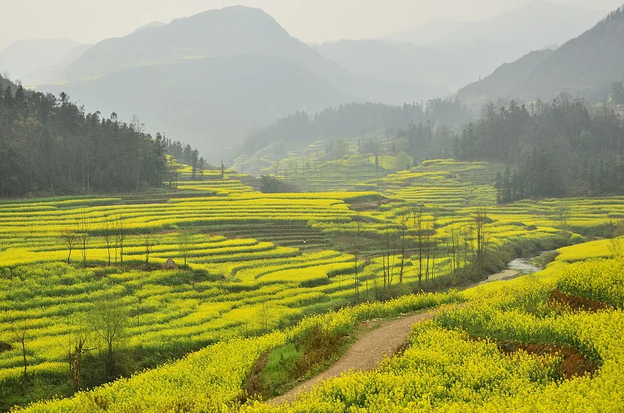
Photo adjustments
Proportionally resized and converted to WebP without cropping, retouching or changing the photographed subject.
- Administrative area
- County · 县
- Part of
- Qujing
- Chinese name
- 罗平县
- Local areas
- County guide
Area & population
- Area in the source
- 2,096.00 km²
Source: cited geographic source, as of the dates shown.
Setting and landscape
Mountains make up 78 percent of the county and flat basins the rest. The highest point is Mount Baila (白腊山), on the boundary between Luoxiong (罗雄) and Jiulong (九龙), and the Nanpan River (南盘江) runs through the south. The county town sits at 1,480 metres, 240 kilometres from Kunming (昆明) and 113 kilometres from central Qujing, and the county government gives the mean annual temperature as 15.1°C.
History
The county government traces the area to the Louwo (漏卧) state of the Western Han, under Zangke Commandery (牂牁郡). In 1276 the Yuan set up Luoxiong Prefecture (罗雄州) under Qujing, renamed Luoping Prefecture (罗平州) in 1587. The name Luoping County dates from 1913. Merged into Shizong (师宗) in 1958, the county was re-established in 1961. Han, Yi, Miao, Buyi (布依), Hui, Shui and Zhuang people live here, and the county government calls Buyi culture "the last civilisation of the twentieth century".
What to see
The rapeseed fields bloom together in February and March, and the county has held a rapeseed flower festival since 1999. In 2002 Shanghai Guinness named Luoping's 300,000 mu of rapeseed the world's largest natural garden.
The Jiulong Waterfalls (九龙瀑布群), 22 kilometres northeast of the county town beside Dule village (堵勒村), form a four-kilometre chain that the local Buyi call Dadieshui (大叠水, "the great cascade"). The largest tier, Shenlong Falls (神龙瀑), is 56 metres high and 112 metres wide. The site became a provincial scenic area in 1993 and a national 4A scenic area in 2004. In 2005 Chinese National Geography (中国国家地理) chose it as China's most beautiful waterfall and the Jinji peak cluster (金鸡峰丛) as China's most beautiful peak forest.
The Luoping biota (罗平生物群) is a Middle Triassic marine fossil assemblage whose first fossil was found in 2007 by the Chengdu centre of the China Geological Survey; its geopark was confirmed as a national geopark in 2016. The Lubuge hydropower station (鲁布革水电站) is listed as a national industrial-tourism demonstration site.
Food and local products
Local dishes include Fule crispy pork (富乐酥肉), Fule dried beef (富乐牛干巴) and Fule jelly (富乐凉粉). In the flowering season, cooks serve cold-dressed rapeseed shoots (凉拌油菜芽) and stir-fried fresh rapeseed flowers (清炒鲜油菜花). The county is a national base for quality bee products, and its small yellow ginger (小黄姜) is on the China-EU geographical indication negotiation list.
Highlights
- Jiulong Waterfalls 九龙瀑布群: A 4 km chain of falls; Shenlong Falls is 56 m high and 112 m wide; national 4A scenic area since 2004.
- Luoping rapeseed fields 罗平油菜花田: Bloom together in February and March; a rapeseed festival has run since 1999.
- Jinji peak cluster 金鸡峰丛: Named China's most beautiful peak forest by Chinese National Geography in 2005.
- Luoping biota 罗平生物群: Middle Triassic marine fossils, first found in 2007; national geopark since 2016.
Sources for this guide
罗平简介 - 罗平县人民政府门户网站 · Luoping County People's Government
罗平县 - 维基百科,自由的百科全书 · Wikipedia (Chinese) · CC BY-SA 4.0
九龙瀑布群 (罗平县) - 维基百科,自由的百科全书 · Wikipedia (Chinese) · CC BY-SA 4.0
罗平生物群 - 维基百科,自由的百科全书 · Wikipedia (Chinese) · CC BY-SA 4.0
Original English written from the listed sources and checked sentence by sentence against quoted extracts by a separate reviewer. Updated 2026-09-25.
Explore Luoping County
Core places to explore, with English and Chinese names.
Places to explore around Luoping County
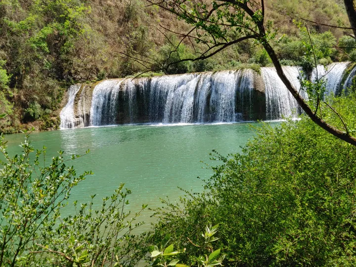 One of the cascades of the Jiulong Waterfalls in Luoping, Yunnan · 云南罗平九龙瀑布群 Source-recorded photograph date: 23 March 2023 (according to Exif data).
Jiulong Waterfalls九龙瀑布群
Luoping’s Jiulong Waterfalls descend in a series along the Jiulong River, with separate drops and pools creating a layered valley view. Shenlong Waterfall is the principal named fall, while higher viewpoints help show how the…
Read the place guide →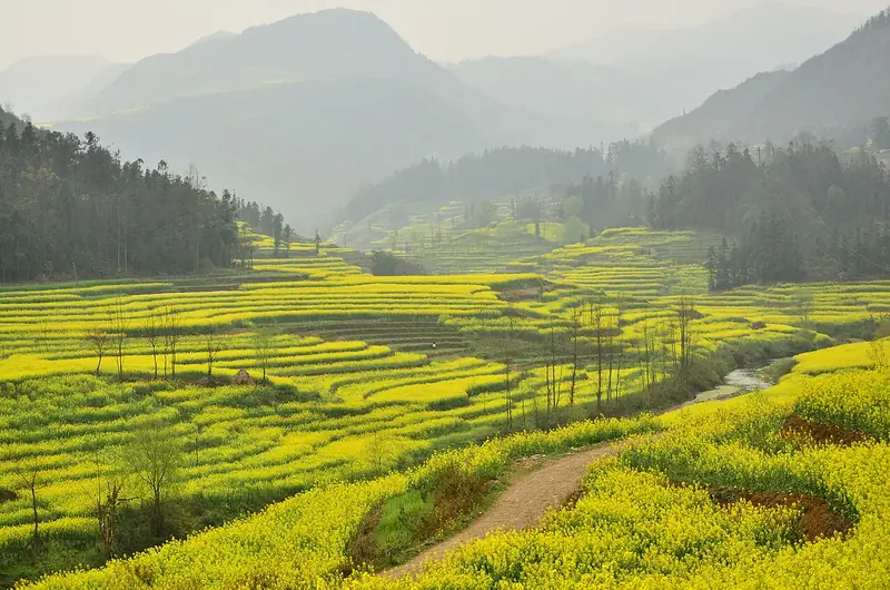 Luoping Rapeseed Flower Fields (罗平油菜花田), Luoping County. Photograph: "Canola field in Luoping".
Luoping Rapeseed Flower Fields罗平油菜花田
Luoping's rape-flower fields are a million-mu expanse of oilseed-rape farmland set among karst peak clusters in Luoping County, Qujing, in bloom around the Lunar New Year.
Read the place guide → Duoyi River · 多依河
Duoyi River多依河
Duoyi River is a 12-kilometre karst river in Luoping County, Qujing, known for a chain of waterfalls along its course and for the Buyi communities settled along its banks.
Read the place guide →Plan your visit
Getting there
Luoping County is about 85 km in a straight line from central Qujing. Search for 罗平县 in a map app to find stations and your accommodation.
Where to stay →Build your route
Jiulong Waterfalls and Luoping Rapeseed Flower Fields are both listed here. The linked place guides have entrance and visit details.
Continue with Qujing →More in Qujing
Sources & geographic information
Administrative names and parent areas: Official geographic directory · Reference date 2026-09-06.
Some facts checked against 罗平县 — Wikipedia contributors, CC BY-SA 4.0.
Some facts checked against 九龙瀑布群 (罗平县) — Wikipedia contributors, CC BY-SA 4.0.
Some facts checked against 罗平生物群 — Wikipedia contributors, CC BY-SA 4.0.
Photo: Jiulong Waterfalls · 储油站 · CC0. Full frame retained; proportionally resized and converted to WebP. No retouching or changes to the photographed subject. Card displays may crop the view.
.jpg)
Photo: Luoping Rapeseed Flower Fields · Fanghong · CC BY-SA 3.0. Full frame retained; EXIF orientation normalized, proportionally resized to at most 800 pixels and converted to WebP. No generated pixels or subject changes. Cards may crop the display.

Photo: Duoyi River · Source photographer · License not provided. EXIF orientation normalized; resized without changing aspect ratio; converted to WebP. No subject edits.
Map data © OpenStreetMap contributors. Pins mark approximate centres, not entrances or boundaries.