


Get to know Xiufeng District
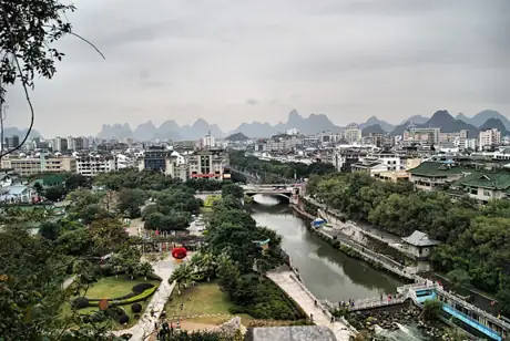
Photo adjustments
Resized and WebP compressed; subject not altered.
- Administrative area
- District · 市辖区
- Part of
- Guilin
- Chinese name
- 秀峰区
- Local areas
- District guide
Area & population
- Area in the source
- 49.00 km²
- Administrative seat
- Jiashan Subdistrict
Source: cited geographic source, as of the dates shown.
History
The Jingjiang Princes' Palace (靖江王府), also called the Prince's City (王城), was begun in 1372 at the southern foot of Solitary Beauty Peak for Zhu Shouqian (朱守谦), a grand-nephew of the first Ming emperor. It was modelled on the Nanjing palace and housed 14 Jingjiang princes over 11 generations. After a fire in 1652 destroyed it, the Qing built the Guangxi examination hall (广西贡院) on the site in 1657. Sun Yat-sen set up his Northern Expedition headquarters here in 1921, and since 1954 the grounds have been a campus of Guangxi Normal University (广西师范大学).
What to see
Inside the palace grounds, the rock face of Solitary Beauty Peak carries dense inscriptions. Among them is the line "Guilin's scenery is the finest under heaven" (桂林山水甲天下), written by Wang Zhenggong (王正功), who took office in Guilin in 1200, at the banquet held after a provincial examination, and later carved at the Reading Cave (读书岩). The site now includes a Jingjiang palace museum and a museum of the imperial examinations.
The district government also lists Reed Flute Cave (芦笛岩), West Hill (西山) with its cliff carvings, the rebuilt Xiaoyao Tower (逍遥楼), the Song-dynasty Old South Gate (古南门) and stretches of Song city wall, as well as the Two Rivers and Four Lakes (两江四湖) waterway.
Old streets and shopping
East-West Lanes (东西巷) lie in front of Zhengyang Gate (正阳城门), where Jiefang East Road meets Zhengyang Road. The quarter keeps former residences of well-known figures, old-name shops and traditional northern-Guangxi houses, and opened in 2016 after rebuilding began in 2013. Next to it, Zhengyang Pedestrian Street (正阳步行街) is lined mainly with Chinese-style replica buildings, shops and snack stalls, and sits close to the Li River and the palace. In 2025 the Guangxi commerce department named East-West Lanes a folk-heritage street and Zhengyang a night-life street.
Highlights
- Jingjiang Princes' Palace 靖江王府: Ming princely palace begun in 1372 at the foot of Solitary Beauty Peak.
- Solitary Beauty Peak 独秀峰: Lone hill whose cliff carries the original inscription of the line on Guilin's scenery.
- East-West Lanes 东西巷: Historic lanes before Zhengyang Gate with old shops and northern-Guangxi houses, opened in 2016.
- Reed Flute Cave 芦笛岩: Listed by the district government among its main tourist sights.
Sources for this guide
秀峰区概况 · Xiufeng District People's Government, Guilin
靖江王府:千年文脉 一城风华 · Guilin Daily, republished by the Xiufeng District People's Government
烟火气+古韵味!桂林东西巷、正阳步行街入选广西特色街区 · Guilin Evening News, republished by the Xiufeng District People's Government
秀峰区 · Wikipedia (Chinese) · CC BY-SA 4.0
Original English written from the listed sources and checked sentence by sentence against quoted extracts by a separate reviewer. Updated 2026-09-25.
Explore Xiufeng District
Core places to explore, with English and Chinese names.
Places to explore around Xiufeng District
 Reed Flute Cave (Ludi Yan) · 芦笛岩
Reed Flute Cave芦笛岩
Reed Flute Cave presents Guilin’s limestone landscape from the inside. Stalactites, stalagmites and other mineral formations fill the chambers, with artificial lighting used to distinguish their shapes. Individual formations…
Read the place guide → The view over Guilin from Duxiu Peak, also called Solitary Beauty Peak, May 2013.
Duxiu Peak独秀峰
Duxiu Peak rises abruptly inside the Jingjiang palace enclosure, creating a limestone landmark in the middle of Guilin. A stair route climbs towards the summit pavilion and city views, while the rock at its base preserves…
Read the place guide →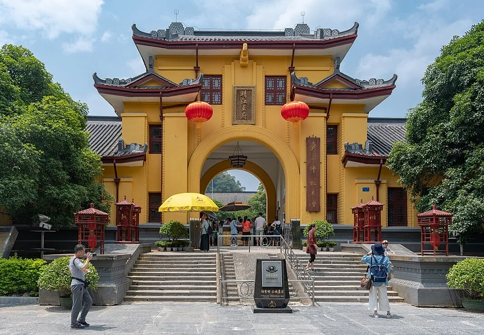 Jingjiang Princes' Palace · 靖江王府. Photo: 2018-06-16 13:52.
Jingjiang Princes' Palace靖江王府
Jingjiang Princes' Palace and Jingjiang Prince City refer to the same historic royal complex in central Guilin, with Solitary Beauty Peak rising inside its grounds. The Ming princely seat combines an enclosed palace layout with…
Read the place guide → Liu Sanjie Cultural Park · 刘三姐大观园
Liu Sanjie Cultural Park刘三姐大观园
Liu Sanjie Cultural Park uses the legendary singer and the film associated with her to frame a designed cultural attraction beside the Taohua River. Its Mo residence recreates a setting from the film, while a timber-built…
Read the place guide → Xiaoyao Tower illuminated at night in Xiufeng District, Guilin · 桂林逍遥楼夜景,秀峰区 Source-recorded photograph date: 2019-07-18 20:44:36.
Xiaoyao Tower逍遥楼
Xiaoyao Tower is a modern reconstruction of a historic Guilin landmark beside the Li River. Its two storeys and three eave levels give the pavilion a layered roofline, with rows of columns below and a surrounding upper gallery…
Read the place guide → The entrance archway of East–West Alley (东西巷) in Xiufeng District, Guilin, at night · 桂林东西巷入口牌坊夜景,秀峰区 Source-recorded photograph date: 2019-08-30 20:27:58.
East–West Alley东西巷
East-West Alley is a restored commercial quarter beside the Jingjiang palace walls. Its three principal lanes—Zhengyang East Alley, Jiangnan Alley and Lanjing Alley—give the area a finer grain than the main roads around it. Old…
Read the place guide → Zhengyang Pedestrian Street in Xiufeng District, Guilin, by day · 桂林正阳步行街日景,秀峰区 Source-recorded photograph date: 2018-06-16 12:21.
Zhengyang Pedestrian Street正阳步行街
Zhengyang is a central shopping street that links the Shan Lake side of the city with Jiefang East Road. Its red clock tower makes a useful meeting point among restaurants, souvenir shops and clothing stores. The side streets…
Read the place guide →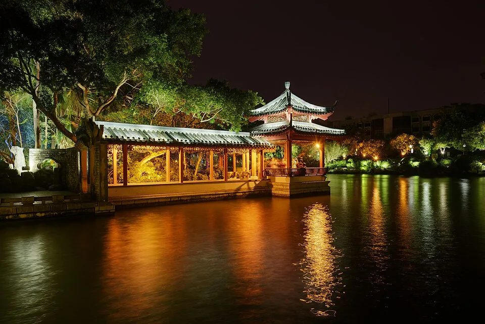 Corridor and pavilion at Rong Lake. The photographer combined three exposures into this HDR photograph. Photo: 2017-11-21 20:31:27.
Rong Lake榕湖
Rong Lake is one of central Guilin’s most architectural lake settings. The old South Gate faces the water from its northern shore, with the large banyan and paired bridges close to the historic approach. Farther into the lake…
Read the place guide → AI illustration · AI 示意图(仅供参考,非该地点实拍)
Gui Lake桂湖
Gui Lake places more emphasis on trees and changing bridge forms than on a single monumental building. Its waterfront includes planted stretches associated with ginkgo, dawn redwoods and camphor trees, interrupted by crossings…
Read the place guide → Shangshui Food Street · 尚水美食街
Shangshui Food Street尚水美食街
Shangshui is a compact food quarter between Zhengyang Pedestrian Street and the Sheraton side of Binjiang Road. Its shopfronts borrow forms from northern Guangxi houses, giving the eating lanes a more intimate setting than the…
Read the place guide → Solitary Beauty Peak and Princes' City · 独秀峰王城
Solitary Beauty Peak and Princes' City独秀峰王城
Duxiufeng Wangcheng (独秀峰王城) is the walled former residence of the Ming-dynasty Prince of Jingjiang, Zhu Shouqian, standing below Duxiu Peak on the west bank of the Li River in Xiufeng District, Guilin, and listed in December 2022 among China's fourth batch of National Archaeological Site Parks.
Read the place guide →Plan your visit
Getting there
Xiufeng District is about 3 km in a straight line from central Guilin. Search for 秀峰区 in a map app to find stations and your accommodation.
Where to stay →Build your route
Reed Flute Cave and Duxiu Peak are about 3 km apart in a straight line. The linked place guides have entrance and visit details.
Continue with Guilin →More in Guilin
Sources & geographic information
Administrative names and parent areas: Official geographic directory · Reference date 2026-09-06.
Some facts checked against 秀峰区 — Wikipedia contributors, CC BY-SA 4.0.
Photo: Reed Flute Cave · Fremantle99 · CC BY-SA 4.0. Wikimedia thumbnail; fitted to the ranking-card frame.

Photo: Duxiu Peak · Chlukoe · CC0. Proportionally resized and converted to WebP without cropping, retouching or changing the photographed subject.

Photo: Jingjiang Princes' Palace · xiquinhosilva · CC BY 2.0. Converted to WebP and resized without changing the subject or cropping the source frame.
.jpg)
Photo: Liu Sanjie Cultural Park · landagent · CC BY-SA 3.0. EXIF orientation normalized; resized without changing aspect ratio; converted to WebP. No subject edits.

Photo: Xiaoyao Tower · 神樂坂秀吉 · CC0. Full frame retained; proportionally resized and converted to WebP. No retouching or changes to the photographed subject. Card displays may crop the view.

Photo: East–West Alley · 神樂坂秀吉 · CC0. Full frame retained; proportionally resized and converted to WebP. No retouching or changes to the photographed subject. Card displays may crop the view.

Photo: Zhengyang Pedestrian Street · xiquinhosilva · CC BY 2.0. Full frame retained; proportionally resized and converted to WebP. No retouching or changes to the photographed subject. Card displays may crop the view.
.jpg)
Photo: Rong Lake · King of Hearts · CC BY-SA 4.0. Converted to WebP and resized without changing the subject or cropping the source frame.

Photo: Shangshui Food Street · Source photographer · License not provided. EXIF orientation normalized; resized without changing aspect ratio; converted to WebP. No subject edits.
Photo: Solitary Beauty Peak and Princes' City · Source photographer · License not provided. EXIF orientation normalized; resized without changing aspect ratio; converted to WebP. No subject edits.
Map data © OpenStreetMap contributors. Pins mark approximate centres, not entrances or boundaries.