


Get to know Taizhou

Photo adjustments
Resized and WebP compressed; subject not altered.
- Administrative area
- Prefecture-level city · 地级市
- Part of
- Zhejiang
- Chinese name
- 台州市
- Local areas
- 9 local areas
Area & population
- Area in the source
- 9,411.00 km²
- Population · 2020 census
- 6,662,888
- Administrative seat
- Jiaojiang District
Source: cited geographic source, as of the dates shown.
Infrastructure and transport
Historically, Taizhou was relatively inaccessible by road due to its mountainous terrain. This has changed due to large infrastructure restructuring in the late 1990s and early 2000s. Presently, Taizhou is served by the S1 Ningbo–Taizhou–Wenzhou Expressway (甬台温高速公路), which is a segment in the north–south G15 Shenyang–Haikou Expressway, linking the city with Ningbo, Shanghai in the north and Wenzhou in the south; the Shangsan Expressway links Taizhou with the provincial capital Hangzhou. Taizhou Luqiao Airport was once named Huangyan Luqiao Airport (IATA:HYN) in the city's Luqiao District serves daily flights to Beijing and Chengdu and regular flights to other major Chinese cities.
Language and culture
Like the majority of areas in Zhejiang, most people from Taizhou speak a dialect of Wu Chinese, known as Taizhou Wu. It is not mutually intelligible with Mandarin Chinese, and only partially intelligible with Shanghainese. There is also a small portion of Min Nan and Wenzhou dialect speakers in the southern regions. None of these three languages are mutually intelligible amongst each other, but the linguistic diversity of some regions has resulted in a segment of the population becoming fluent in speaking up to four languages, when Mandarin is included.
The city's people are reputed to be industrious and business-minded, although not to the same degree as neighboring Wenzhou. Many people from the area have migrated abroad after economic reforms began in China in 1978. The city's seafood is of note.
Explore Taizhou
Core places to explore, with English and Chinese names.
Tiantai Mountain 天台山
Guoqing Temple 国清寺
Shenxianju 神仙居
Taizhou Prefecture City Wall 台州府城墙
Taizhou Museum 台州博物馆
Wenling Changyu Dongtian national scenic spot 长屿硐天
Shepan Island 蛇蟠岛
Ziyang Street 紫阳街
Linhai East Lake 东湖
Potan Ancient Town 皤滩古镇
Shiliang Waterfall 石梁飞瀑
Tiantai Mountain Great Waterfall 天台山大瀑布
Qiongtai Fairy Valley 琼台仙谷
Dachen Island 大陈岛
Shitang Town 石塘
Yuhuan Dalu Island 大鹿岛
Jiaojiang District 椒江区
Huangyan District 黄岩区
Luqiao District 路桥区
Sanmen County 三门县
Tiantai County 天台县
Xianju County 仙居县
Wenling 温岭市
Linhai 临海市
Yuhuan 玉环市
Places to explore around Taizhou
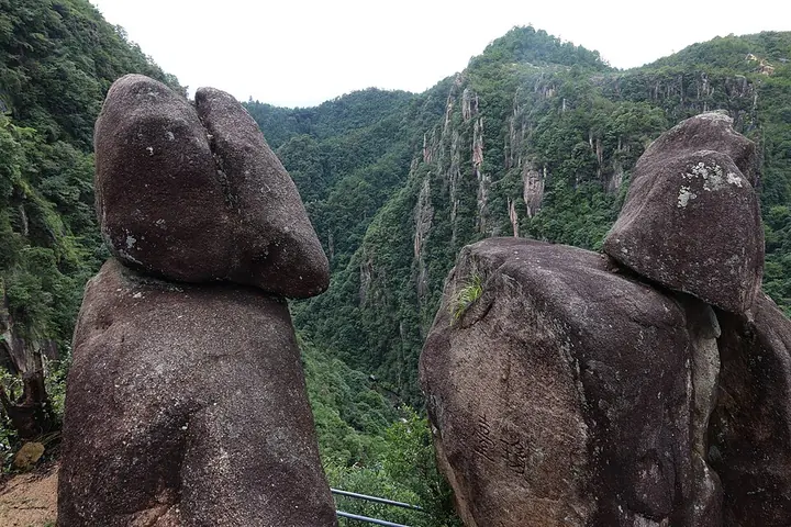 Rock formations at Qiongtai on Tiantai Mountain · 天台山琼台 Photograph date recorded by the source: 26 July 2025, 14:27:13.
Tiantai Mountain天台山
Tiantai Mountain combines Buddhist pilgrimage sites with forested ridges and waterfalls across several separate scenic areas. Guoqing Temple provides the historical focus for the Tiantai Buddhist tradition, while Shiliang’s…
Read the place guide → A hall at Guoqing Temple on Tiantai Mountain · 国清寺 Photograph date recorded by the source: 27 December 2014, 12:36:36.
Guoqing Temple国清寺
Guoqing Temple stands at the foot of Tiantai Mountain and is closely associated with the Tiantai Buddhist tradition and its Japanese Tendai connections. Its present halls reflect repeated rebuilding and restoration, while the…
Read the place guide → A bridge across the gorge at Shenxianju · 神仙居 Photograph date recorded by the source: 10 November 2019, 16:25:03.
Shenxianju神仙居
Shenxianju pairs steep rock peaks with bridges and elevated paths that reveal the depth of its gorges. Ruyi Bridge’s curved form is the most recognizable engineered viewpoint, while Guanyin Peak provides a contrasting natural…
Read the place guide → The ancient Taizhou Prefecture city wall along the Lingjiang River, Linhai, Zhejiang · 浙江临海台州府城墙与灵江 Source-recorded photograph date: 2010-10-02.
Taizhou Prefecture City Wall台州府城墙
The Taizhou Prefecture City Wall surrounds the historic core of Linhai, rather than modern central Taizhou at Jiaojiang. Its hillside and riverside sections served different purposes: the northern line follows the ridge, while…
Read the place guide →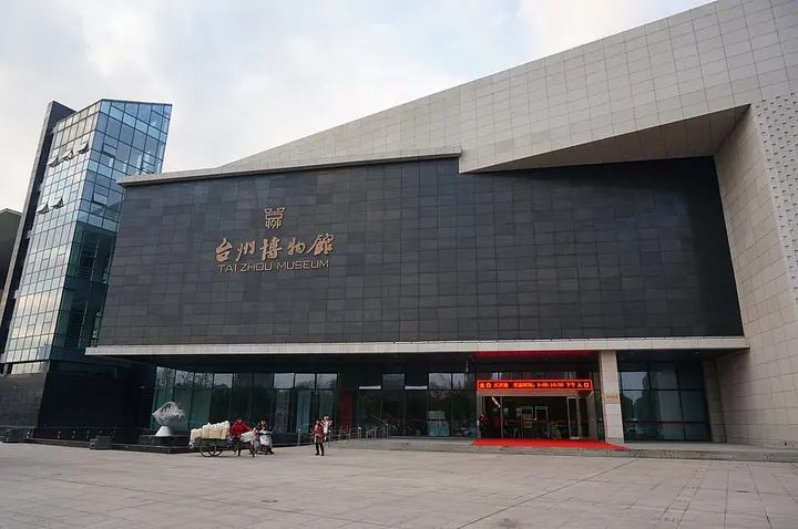 South facade of Taizhou Museum, Zhejiang · 浙江台州博物馆南面 Photograph date recorded by the source: 1 January 2017, 16:41:12.
Taizhou Museum台州博物馆
Taizhou Museum uses the contrast between mountain valleys, lowland fields and the coast to explain local life. The historical exhibition places the region’s material culture in context, while the folk-life displays compare…
Read the place guide → The karst hillside riddled with grotto entrances at Changyu Dongtian scenic area, Wenling · 温岭长屿硐天景区,山体上分布的硐穴入口 Source-recorded photograph date: 30 October 2008 (original upload date).
Wenling Changyu Dongtian national scenic spot长屿硐天
Changyu Dongtian is a landscape of chambers cut by generations of stone quarrying in Wenling. The walls, corridors and open voids reveal extraction rather than natural cave formation. Guanxi Cave adds a large carved stone bowl…
Read the place guide → Shepan Island · 蛇蟠岛
Shepan Island蛇蟠岛
Former island in Sanmen Bay, Zhejiang, quarried since the Song dynasty and left with more than 1,300 man-made caves in brownish-red shepan stone.
Read the place guide → Ziyang Street · 紫阳街
Ziyang Street紫阳街
Ziyang Street runs through Linhai's old Taizhou prefectural city, where arched firebreak walls and historic wells punctuate the street and its adjoining lanes.
Read the place guide → A broad dark lake seen from the water at its southern end, with a small boat and a tour boat out on it, a wooded shore carrying a pavilion, a gate and white buildings on the far side, and a blue mountain range behind under a cloud-streaked sky.
Linhai East Lake东湖
Donghu is a historic garden lake immediately east of the old Taizhou city wall in Linhai, developed from waters once used for naval mooring and troop stationing.
Read the place guide →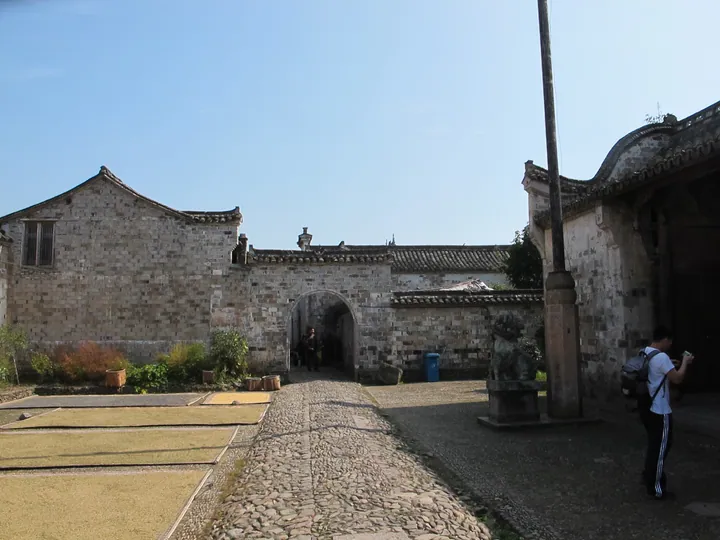 Old stone courtyard and gateway in Potan Ancient Town, Xianju County, Taizhou · 台州市仙居县皤滩古镇,古街石砌门楼与晒谷场 Source-recorded photograph date: Taken on 22 October 2011.
Potan Ancient Town皤滩古镇
Potan developed as a trading town where river transport along the Yong'an and Ling waterways met the Cangling route into inland Zhejiang, with salt central to its prosperity.
Read the place guide → Shiliang Waterfall · 石梁飞瀑
Shiliang Waterfall石梁飞瀑
Waterfall in Tiantai, Zhejiang, pouring beneath a natural stone beam, with old cliff inscriptions and temples linked to the Five Hundred Arhats.
Read the place guide → AI illustration · AI 示意图(仅供参考,非该地点实拍)
Tiantai Mountain Great Waterfall天台山大瀑布
Tiantai Mountain's Great Waterfall is a restored nine-stage cascade on the western slopes of Tongbai Mountain, where a diversion system returned water to a historic waterfall landscape.
Read the place guide →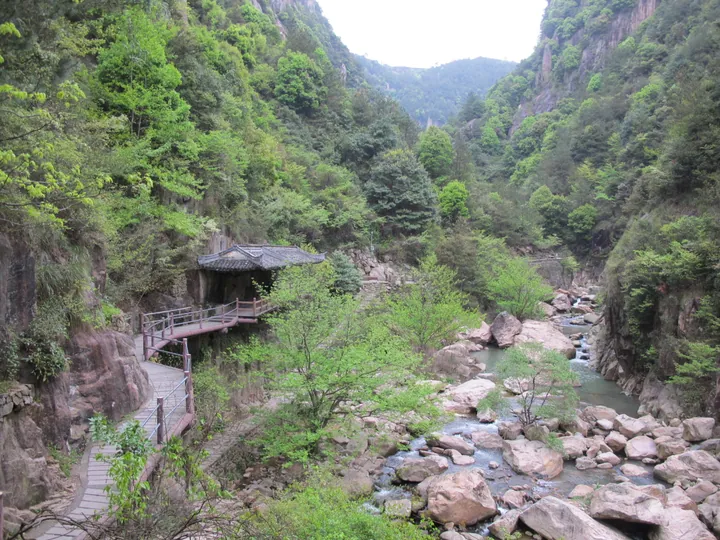 A wooden walkway and pavilion beside the stream in Qiongtai Xiangu scenic gorge, Tiantai County, Taizhou · 台州市天台县琼台仙谷景区中的溪流栈道与亭阁 Source-recorded photograph date: Taken on 6 April 2013.
Qiongtai Fairy Valley琼台仙谷
Qiongtai Xiangu in Tiantai is a steep granite valley where Baxian Lake, cliffside paths and waterfalls create a sequence of enclosed mountain views.
Read the place guide →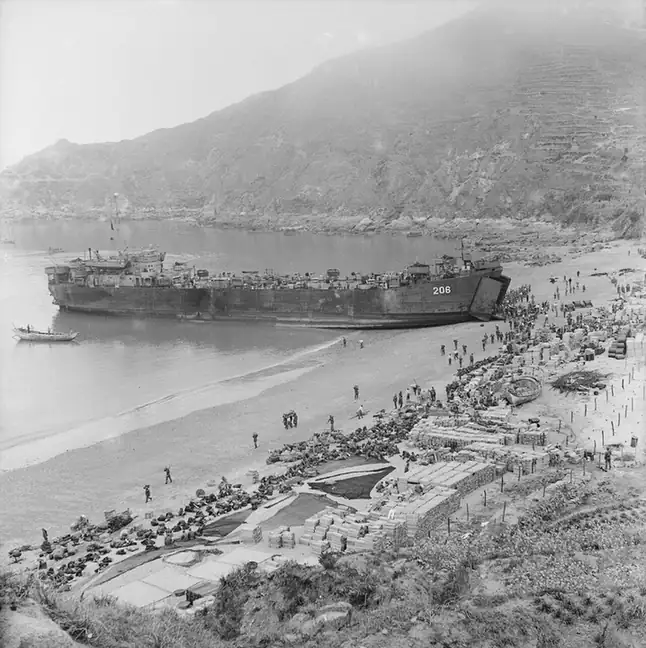 Dachen Island · 大陈岛
Dachen Island大陈岛
Island group off Taizhou, Zhejiang, evacuated by the Nationalists in 1955 and resettled by 467 young volunteers, with cliff trails and a reclamation monument.
Read the place guide → AI illustration · AI 示意图(仅供参考,非该地点实拍)
Shitang Town石塘
Shitang in coastal Wenling is known for stone houses, carved stone windows and stepped lanes arranged across hillsides beside the sea.
Read the place guide → Yuhuan Dalu Island · 大鹿岛
Yuhuan Dalu Island大鹿岛
Dalu Island off southeastern Yuhuan combines a planted island forest with sea-eroded volcanic rock and marine-animal sculptures carved into the stone.
Read the place guide →Local life & food
Taizhou local specialties
台州市特色美食 · 13 specialties to discover
 Linhai egg-white fritters 蛋清羊尾AI illustration · AI 示意图
The outside is airy and tender, while the center is smooth and sweet. Freshness is crucial because the foam-based shell settles as it cools.
Source ↗Read the dish guide → Taizhou ginger-broth noodles 姜汤面AI illustration · AI 示意图
The broth has a warm, peppery ginger bite rather than necessarily a chili burn; tender noodles absorb that aroma.
Source ↗Read the dish guide → Taizhou stuffed pancake rolls 食饼筒AI illustration · AI 示意图
The wrapper stays supple while the mixed filling gives every bite a different texture and flavor. It can be much more filling than its thin exterior suggests.
Source ↗Read the dish guide → Maixia Wheat Dough Soup 麦虾
Maixia Wheat Dough Soup (麦虾) is a local snack of Linhai (临海) in Taizhou (台州), made by cutting strips of flour batter directly into boiling broth.
Read the dish guide →Photo adjustments
EXIF orientation normalized; resized without changing aspect ratio; converted to WebP. No subject edits.
 Linhai thick festival soup 糟羹AI illustration · AI 示意图
The texture is soft and spoonable, with little contrasting bites suspended in the thick base. Flavor depends on which version is served.
Source ↗Read the dish guide → Wenling Stuffed Rice Cake 温岭嵌糕AI illustration · AI 示意图(仅供参考,非实拍)
Wenling Stuffed Rice Cake (温岭嵌糕) is a breakfast of soft rice cake wrapped around a savoury filling, from Wenling (温岭), a county-level city of Taizhou (台州) on the southeast coast of Zhejiang.
Read the dish guide → Linhai Stuffed Wheat Flatbread 临海麦饼AI illustration · AI 示意图(仅供参考,非实拍)
Linhai Stuffed Wheat Flatbread (临海麦饼) is a soft, filled flatbread from Linhai (临海), Taizhou (台州). A local newspaper feature describes versions with pork, potato, salted-vegetable-and-cold-rice, or egg-and-meat fillings.
Read the dish guide →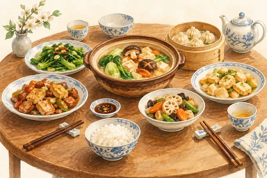 Linhai Puffed Shrimp Fritters 临海泡虾AI illustration · AI 示意图(仅供参考,非实拍)
Linhai Puffed Shrimp Fritters (临海泡虾) are a deep-fried snack of shrimp and pork filling in batter from Linhai (临海) in Taizhou (台州), Zhejiang. 'Paoxia' is the Taizhou dialect name; the written Chinese name is yougu (油鼓).
Read the dish guide →All dish names · 全部菜名 (13)
- Linhai egg-white fritters · 蛋清羊尾
- Taizhou ginger-broth noodles · 姜汤面
- Taizhou stuffed pancake rolls · 食饼筒
- Maixia Wheat Dough Soup · 麦虾
- Linhai thick festival soup · 糟羹
- Wenling Stuffed Rice Cake · 温岭嵌糕
- Linhai Stuffed Wheat Flatbread · 临海麦饼
- Linhai Puffed Shrimp Fritters · 临海泡虾
- Sanmen Mud Crab · 三门青蟹
- Yuhuan Fish-Skin Wontons · 玉环鱼皮馄饨
- Xianju Eight-Bowl Banquet · 仙居八大碗
- Tiantai Stuffed Pancake Rolls · 天台饺饼筒
- Black Glutinous Rice Cakes · 乌饭麻糍
More dishes from across Zhejiang are in the Zhejiang food guide.
Counties & districts in Taizhou
9 areas belong directly to Taizhou.
9 areas
Jiaojiang District 椒江区
Jiaojiang District (Tai-chow dialect: Tsiao-kông K'ü; simplified Chinese: 椒江区; traditional Chinese: 椒江區; pinyin: Jiāojiāng Qū) is a district and the seat of the prefecture-level city of Taizhou in Zhejiang…
Explore the area →DistrictHuangyan District 黄岩区
Huangyan (; Tai-chow dialect: Wông-ngæn K'ü; simplified Chinese: 黄岩区; traditional Chinese: 黃巖區; pinyin: Huángyán Qū) is a district of Taizhou, a city in Zhejiang Province, China.
Explore the area →DistrictLuqiao District 路桥区
Luqiao District (simplified Chinese: 路桥区; traditional Chinese: 路橋區; pinyin: Lùqiáo Qū; Tai-chow dialect: Lu-giao K'ü) is a district of Taizhou in Zhejiang Province, People's Republic of China.
Explore the area →CountySanmen County 三门县
Sanmen County (Tai-chow dialect: Sæn-meng Yön; simplified Chinese: 三门县; traditional Chinese: 三門縣; pinyin: Sānmén Xiàn) is a coastal county under the jurisdiction of the prefecture-level city of Taizhou in the…
Explore the area →Show fewer areas
Tiantai County 天台县
Tiantai County (Tai-chow dialect: T'in-t'e yön; simplified Chinese: 天台县; traditional Chinese: 天台縣; pinyin: PRC Standard Mandarin: Tiāntāi Xiàn, ROC Standard Mandarin: Tiāntái Xiàn) is located in Taizhou…
Explore the area →CountyXianju County 仙居县
Xianju County is a county of Zhejiang, China. It is under the administration of the Taizhou city. It is the location of Shenxianju, a geological site protected by the Chinese government.
Explore the area →County-level cityWenling 温岭市
Wenling (Wenling dialect: Ueng-ling Zy [ʔuəŋ ʔliŋ zɿ]; simplified Chinese: 温岭市; traditional Chinese: 溫嶺市; pinyin: Wēnlǐng Shì) is a coastal county-level city in the municipal region of Taizhou, in…
Explore the area →County-level cityLinhai 临海市
Linhai (simplified Chinese: 临海; traditional Chinese: 臨海; pinyin: Línhǎi; Tai-chow dialect: Lin-he) is a county-level city in Taizhou, Zhejiang province, situated on the banks of the Lin River in Eastern China.
Explore the area →County-level cityYuhuan 玉环市
Yuhuan (simplified Chinese: 玉环; traditional Chinese: 玉環; pinyin: Yùhuán) is a county-level city of Taizhou, at the midsection along the coast of southeastern Zhejiang Province, China.
Explore the area →No areas match this name.
Plan your visit
Getting there
Search for 台州市 in a map app to find stations and your accommodation.
Where to stay →Build your route
Tiantai Mountain and Guoqing Temple are less than 1 km apart. The linked place guides have entrance and visit details.
Continue with Zhejiang →More in Zhejiang
Sources & geographic information
Administrative names and parent areas: Official geographic directory · Reference date 2026-09-06.
Background text adapted from Taizhou, Zhejiang — Wikipedia contributors, under CC BY-SA 4.0. Text has been shortened and reorganized; source revision 1330479652.
Photo: Tiantai Mountain · 松照庵 · CC BY-SA 4.0. Full frame retained; proportionally resized and converted to WebP. No retouching or changes to the photographed subject. Card displays may crop the view.

Photo: Guoqing Temple · Siyuwj · CC BY-SA 4.0. Full frame retained; proportionally resized and converted to WebP. No retouching or changes to the photographed subject. Card displays may crop the view.

Photo: Shenxianju · 钉钉 · CC BY-SA 4.0. Full frame retained; proportionally resized and converted to WebP. No retouching or changes to the photographed subject. Card displays may crop the view.

Photo: Taizhou Prefecture City Wall · Marcus Hsu talk · CC BY 3.0. Full frame retained; proportionally resized and converted to WebP. No retouching or changes to the photographed subject. Card displays may crop the view.

Photo: Taizhou Museum · 猫猫的日记本 · 猫猫的日记本 — Taizhou_Museum,_Zhejiang_01_2017-01.jpg — CC BY-SA 4.0 · CC BY-SA 4.0. Full frame retained; proportionally resized and converted to WebP. No retouching or changes to the photographed subject. Card displays may crop the view.

Photo: Wenling Changyu Dongtian national scenic spot · Likaihua · CC BY-SA 3.0. Full frame retained; proportionally resized and converted to WebP. No retouching or changes to the photographed subject. Card displays may crop the view.

Photo: Shepan Island · Source photographer · License not provided. EXIF orientation normalized; resized without changing aspect ratio; converted to WebP. No subject edits.
Photo: Ziyang Street · Source photographer · License not provided. EXIF orientation normalized; resized without changing aspect ratio; converted to WebP. No subject edits.
Photo: Linhai East Lake · 猫猫的日记本 · CC BY-SA 4.0. Full frame retained; proportionally resized and converted to WebP. No retouching or changes to the photographed subject. Card displays may crop the view.

Photo: Potan Ancient Town · 江上清风1961 · CC BY 3.0. Full frame retained; proportionally resized and converted to WebP. No retouching or changes to the photographed subject. Card displays may crop the view.

Photo: Shiliang Waterfall · Source photographer · License not provided. EXIF orientation normalized; resized without changing aspect ratio; converted to WebP. No subject edits.
Photo: Qiongtai Fairy Valley · 江上清风1961 · CC BY 3.0. Full frame retained; proportionally resized and converted to WebP. No retouching or changes to the photographed subject. Card displays may crop the view.
.jpg)
Photo: Dachen Island · 行政院新聞局 · Public domain. EXIF orientation normalized; resized without changing aspect ratio; converted to WebP. No subject edits.

Photo: Yuhuan Dalu Island · Micromesistius · CC BY-SA 3.0. EXIF orientation normalized; resized without changing aspect ratio; converted to WebP. No subject edits.

Map data © OpenStreetMap contributors. Pins mark approximate centres, not entrances or boundaries.