


Get to know Chengde County
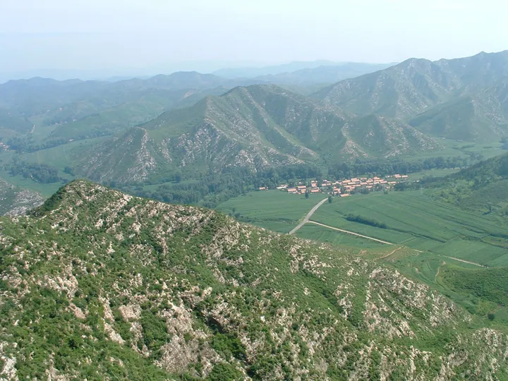
Photo adjustments
Full frame retained; proportionally resized and converted to WebP. No retouching or changes to the photographed subject. Card displays may crop the view.
- Administrative area
- County · 县
- Part of
- Chengde
- Chinese name
- 承德县
- Local areas
- County guide
Area & population
- Area in the source
- 3,695.00 km²
- Population · 2020 census
- 340,579
Source: cited geographic source, as of the dates shown.
Setting and history
Forest covers 61.5 percent of the county, the mean annual temperature is 7.5 °C and about 550 millimetres of rain fall in a year. Under the Qing the area belonged to the Rehe sub-prefecture from 1723 and to Chengde Prefecture from 1778; in February 1913 the Beijing government abolished the prefecture and set up Chengde County in its place.
What to see
The Tangquan Palace (汤泉行宫) at Tangquan village in Tougou town (头沟镇) is a Qing travelling palace built over a hot spring at the foot of Tang Mountain, 40 kilometres north-east of Chengde city. It is the only one of 22 Qing palaces beyond the Great Wall, apart from the Mountain Resort, that survives. A Liao prince bathed here in 999. The Kangxi Emperor first came in 1692, built the palace in 1706 on the site of a Dragon King temple and came back thirteen more times. The palace keeps its gate hall and main hall, a square spring pool 7.5 metres a side ringed by carved stone balustrades, and Kangxi's stele of 1716. It became a Hebei provincial protected site in 1982.
The county government also points to the Chaoliangzi stele (朝梁子按语碑), carved with instructions from Mao Zedong, and to Qiaozhangzi (乔杖子), which the Ministry of Culture named a home of Chinese folk art for its paper-cutting.
Food and local products
Chengde Guoguang apples (国光苹果) and Bancheng Shaoguo liquor (板城烧锅酒) are both national geographical-indication products. The liquor is distilled from sorghum and wheat by the old five-steamer (老五甑) method: fermented grain from the pit is steamed with fresh grain in the same steamer and split into five batches, so the grain ferments several times over. The technique entered the second national intangible heritage list in 2008. Local legend says the liquor got its name in 1773, when the Qianlong Emperor and the scholar Ji Xiaolan (纪晓岚) drank it at the Qingyuanheng tavern (庆元亨酒店) in Xiabancheng.
Getting oriented
Four railways cross the county: the Beijing–Chengde, Jinzhou–Chengde, Chengde–Longhua and Zhangjiakou–Tangshan lines. The Beijing–Harbin high-speed line has two passenger stations here, Chengde Puning Airport (承德普宁机场) lies within the county, and expressways run towards Tangshan, Chaoyang, Chifeng and Qinhuangdao.
Highlights
- Tangquan Palace 汤泉行宫: Kangxi's hot-spring palace of 1706, the only survivor besides the Mountain Resort of 22 Qing palaces beyond the Great Wall.
- Bancheng Shaoguo liquor 板城烧锅酒: Sorghum-and-wheat liquor made by the old five-steamer method, national intangible heritage since 2008.
- Guoguang apples 国光苹果: Chengde Guoguang apples are a national geographical-indication product.
- Qiaozhangzi paper-cutting 乔杖子剪纸: Qiaozhangzi was named a home of Chinese folk art by the Ministry of Culture.
Sources for this guide
本县概况 · Chengde County People's Government
蒸馏酒传统酿造技艺(板城烧锅酒传统五甑酿造技艺) - 中国非物质文化遗产网·中国非物质文化遗产数字博物馆 · China Intangible Cultural Heritage Network (ihchina.cn)
汤泉行宫 - 维基百科,自由的百科全书 · Chinese Wikipedia · CC BY-SA 4.0
承德县 - 维基百科,自由的百科全书 · Chinese Wikipedia · CC BY-SA 4.0
Original English written from the listed sources and checked sentence by sentence against quoted extracts by a separate reviewer. Updated 2026-09-24.
Explore Chengde County
Core places to explore, with English and Chinese names.
Chengde County 承德县
Plan your visit
Getting there
Chengde County is about 25 km in a straight line from central Chengde. Search for 承德县 in a map app to find stations and your accommodation.
Where to stay →More in Chengde
Sources & geographic information
Administrative names and parent areas: Official geographic directory · Reference date 2026-09-06.
Some facts checked against 汤泉行宫 — Wikipedia contributors, CC BY-SA 4.0.
Some facts checked against 承德县 — Wikipedia contributors, CC BY-SA 4.0.
Map data © OpenStreetMap contributors. Pins mark approximate centres, not entrances or boundaries.