


Get to know Shuangluan District
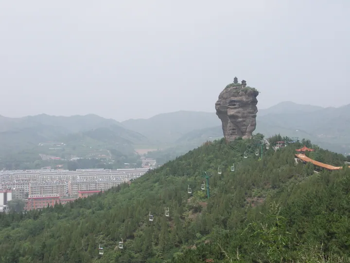
Photo adjustments
Full frame retained; proportionally resized and converted to WebP. No retouching or changes to the photographed subject. Card displays may crop the view.
- Administrative area
- District · 市辖区
- Part of
- Chengde
- Chinese name
- 双滦区
- Local areas
- District guide
Area & population
- Population · 2020 census
- 187,361
- Administrative seat
- Yuanbaoshan Subdistrict (元宝山街道)
Source: cited geographic source, as of the dates shown.
Setting and landscape
The district lies in a transition zone between warm-temperate broadleaf forest and temperate grassland, with a semi-humid continental monsoon climate. The Chengde tourism bureau lists the Shuangtashan Luan River wetland (双塔山滦河) among the five national wetland parks of Chengde, and counts Shuangta Mountain among the city's ten notable peaks and caves.
What to see
Shuangta Mountain is named for two huge rock pillars standing side by side on a north–south line, wider at the top than at the base and a little over 40 metres high. A brick pagoda stands on each summit, and the Beijing Tourism Network dates both to the Liao dynasty. The scenic area around them is forested.
Shibapan village (十八盘村) in Pianqiaozi town (偏桥子镇), in the Luan River valley and 9 km in a straight line from the Mountain Resort (避暑山庄), was the main quarry for the stone used to build and repair the Qing summer palace. Its old name was Shibapan (石八盘, "eight stone bends"), and a stone temple, stone walls, millstones and grain rollers survive in the village. The district government lists Lotus Valley (莲花山谷), the staged show "Dingsheng Wangchao: Kangxi Dadian" (鼎盛王朝·康熙大典) and Shuangta Mountain as scenic areas near the village. Pianqiaozi is known for greenhouse strawberries, grapes and cucumbers.
In Chenzhazi town (陈栅子镇), the Yunpan road (云盘路) runs through Erxingying (二兴营村) and Huangliang (黄粱村) villages past terraced fields; the district government describes Huangliang as a self-drive destination for farm stays and fruit picking.
Highlights
- Shuangta Mountain 双塔山: Twin rock pillars of about 40 m, each crowned with a brick pagoda dated to the Liao dynasty.
- Shibapan village 十八盘村: Main source of the stone used to build and repair the Mountain Resort; stone temple and walls survive.
Sources for this guide
对承德市政协十五届一次会议第0154号建议的答复 · Shuangluan District People's Government (Agriculture and Rural Affairs Bureau)
秋游河北 | 秋日来承德,这些美景你不容错过! · Beijing Tourism Network (visitbeijing.com.cn)
承德市旅游和文化广电局 动态要闻 承德民宿相关名词 · Chengde Municipal Bureau of Tourism, Culture, Radio and Television
双滦区 - 维基百科,自由的百科全书 · Wikipedia · CC BY-SA 4.0
Original English written from the listed sources and checked sentence by sentence against quoted extracts by a separate reviewer. Updated 2026-09-24.
Explore Shuangluan District
Core places to explore, with English and Chinese names.
Places to explore around Shuangluan District
 A green wooded hillside with a tall rock pinnacle crowned by two small pagodas standing on its ridge, a town spreading below to the left, distant blue hills, and a carved stone marker reading
 Plan your visit
Getting there
Shuangluan District is about 15 km in a straight line from central Chengde. Search for 双滦区 in a map app to find stations and your accommodation.
Where to stay →Build your route
Start with Shuangta Mountain. The linked place guides have entrance and visit details.
Continue with Chengde →More in Chengde
Sources & geographic information
Administrative names and parent areas: Official geographic directory · Reference date 2026-09-06.
Some facts checked against 双滦区 — Wikipedia contributors, CC BY-SA 4.0.
Photo: Shuangta Mountain · H2v5o68z · CC0. Full frame retained; proportionally resized and converted to WebP. No retouching or changes to the photographed subject. Card displays may crop the view.

Map data © OpenStreetMap contributors. Pins mark approximate centres, not entrances or boundaries.