


Get to know Fengning Manchu Autonomous County
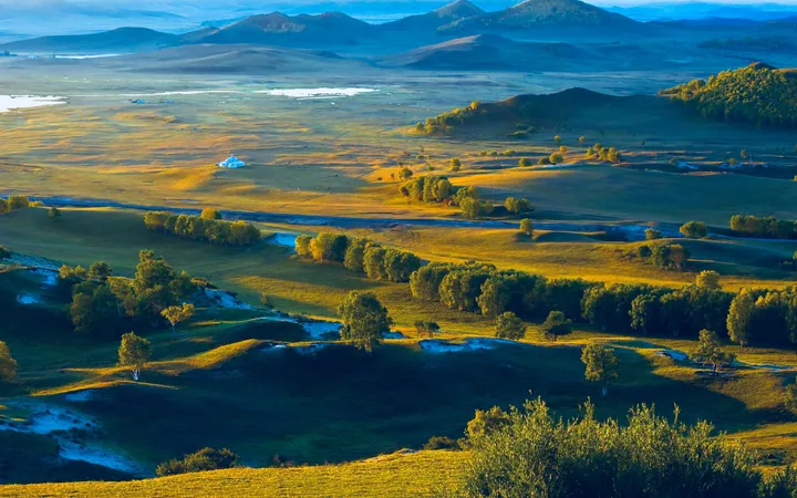
Photo adjustments
Full frame retained; proportionally resized and converted to WebP. No retouching or changes to the photographed subject. Card displays may crop the view.
- Administrative area
- Autonomous county · 自治县
- Part of
- Chengde
- Chinese name
- 丰宁满族自治县
- Local areas
- Autonomous county guide
Area & population
- Area in the source
- 8,765.00 km²
- Population · 2020 census
- 326,353
- Administrative seat
- Dage
Source: cited geographic source, as of the dates shown.
Setting and landscape
The county covers 8,765 square kilometres in three bands of terrain: the Bashang plateau, the Jieba (接坝) belt that adjoins it and the Baxia (坝下) area below, which takes up more than half the county. Both the Chao River (潮河) and the Luan River (滦河), sources of drinking water for Beijing and Tianjin, rise in Fengning. Sunshine is plentiful, about 2,750 hours a year; the mean temperature is 7.3 °C and 350 to 550 millimetres of rain fall a year, and forest covers 58.53 percent of the land.
History
People lived here 30,000 to 50,000 years ago, and sites of the Hongshan (红山) and Shanrong (山戎) cultures have been found. The Qing set up the Siqi sub-prefecture (四旗厅) in 1735 and renamed it Fengning County in 1778, from a phrase meaning abundance and peace; the autonomous county dates from 1987. The fossil Jinfengopteryx (华美金凤鸟) was found in the county, and in 2023 two plant-eating dinosaurs of the Jehol Biota (热河生物群), more than 130 million years old, were found: a nearly complete early horned dinosaur of a new genus and a stegosaur preserved with skin impressions.
What to see and hear
The county lists four 4A scenic areas: the Jingbei No. 1 Grassland (京北第一草原), the Great Khan Palace (大汗行宫), China Horse Town (中国马镇) and Qicai Forest (七彩森林). Among its 3A areas is the Baiyun Ancient Cave (白云古洞).
Fengning Manchu paper-cutting (丰宁满族剪纸) entered the first national intangible heritage list in 2006. It dates from the Kangxi reign, is cut mainly in positive relief with long, fine fringed lines, and ranges from window flowers to ancestral hanging tags; in 1993 the Ministry of Culture named Fengning a home of Chinese folk paper-cutting. The Manchu Chaozi Hui (丰宁满族吵子会), on the national list since 2008, is a village band of two suona players and ten percussionists led by the leather-gong player, with about three centuries of history.
Getting oriented
Fengning borders Huairou District (怀柔区) of Beijing, and the county town is 18 kilometres from the Huairou boundary. The Duolun–Fengning and Tangshan–Baotou railways cross the county, and the Zhangjiakou–Chengde Expressway runs 138 kilometres through it.
Highlights
- Jingbei No. 1 Grassland 京北第一草原: One of the four 4A scenic areas listed by the county government.
- Great Khan Palace 大汗行宫: One of the county's four 4A scenic areas.
- Fengning Manchu paper-cutting 丰宁满族剪纸: Paper-cutting dating from the Kangxi reign, on the first national intangible heritage list (2006).
- Manchu Chaozi Hui 丰宁满族吵子会: Suona-and-percussion village band tradition of about 300 years, national intangible heritage since 2008.
Sources for this guide
丰宁概况 · Fengning Manchu Autonomous County People's Government
剪纸(丰宁满族剪纸) - 中国非物质文化遗产网·中国非物质文化遗产数字博物馆 · China Intangible Cultural Heritage Network (ihchina.cn)
唢呐艺术(丰宁满族吵子会) - 中国非物质文化遗产网·中国非物质文化遗产数字博物馆 · China Intangible Cultural Heritage Network (ihchina.cn)
Original English written from the listed sources and checked sentence by sentence against quoted extracts by a separate reviewer. Updated 2026-09-24.
Explore Fengning Manchu Autonomous County
Core places to explore, with English and Chinese names.
Places to explore around Fengning Manchu Autonomous County
 Jingbei First Grassland · 京北第一草原
Jingbei First Grassland京北第一草原
Jingbei First Grassland (京北第一草原) is the Bashang plateau grassland landscape around Datan in Fengning Manchu Autonomous County, shaped by meadows, marshes and rivers.
Read the place guide → Great Khan's Palace · 大汗行宫
Great Khan's Palace大汗行宫
Dahan Xinggong (大汗行宫) is a modern Mongol–Yuan cultural attraction in Fengning's Datan grassland area, designed around a ceremonial palace and camp setting.
Read the place guide →Plan your visit
Getting there
Fengning Manchu Autonomous County is about 115 km in a straight line from central Chengde. Search for 丰宁满族自治县 in a map app to find stations and your accommodation.
Where to stay →Build your route
Jingbei First Grassland and Great Khan's Palace are both listed here. The linked place guides have entrance and visit details.
Continue with Chengde →More in Chengde
Sources & geographic information
Administrative names and parent areas: Official geographic directory · Reference date 2026-09-06.
Photo: Jingbei First Grassland · Source photographer · License not provided. EXIF orientation normalized; resized without changing aspect ratio; converted to WebP. No subject edits.
Photo: Great Khan's Palace · Source photographer · License not provided. EXIF orientation normalized; resized without changing aspect ratio; converted to WebP. No subject edits.
Map data © OpenStreetMap contributors. Pins mark approximate centres, not entrances or boundaries.