


Get to know Weihui
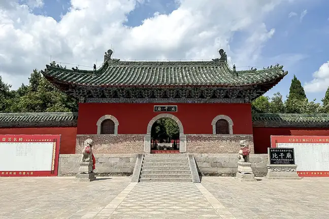
Photo adjustments
EXIF orientation normalized; resized without changing aspect ratio; converted to WebP. No subject edits.
- Administrative area
- County-level city · 县级市
- Part of
- Xinxiang
- Chinese name
- 卫辉市
- Local areas
- County-level city guide
Area & population
- Area in the source
- 882.00 km²
- Population · 2019
- 490,700
Source: cited geographic source, as of the dates shown.
Setting and landscape
The city government places Weihui in the core of the southern Taihang, with sheer red cliffs and mountain villages; Cangyu Mountain (苍峪山) and Linluo Mountain (霖落山) are its main mountain landscapes. Four medium and large rivers and four smaller reservoirs lie within its borders, and the central route of the South–North Water Diversion canal crosses it.
History
Ji County was created in the second year of Emperor Gaozu of the Western Han, and the town later served as the seat of commanderies, prefectures and circuits. The Bamboo Annals (竹书纪年), an early chronicle, were found in a Warring States tomb of the state of Wei in Ji Commandery. Local tradition makes Weihui the home of the strategist Jiang Taigong (姜太公), the burial place of Bi Gan (比干), a member of the Shang royal house, and the origin of the Lin (林) surname. It was the fief of the Ming prince Zhu Yiliu (朱翊镠) and the birthplace of Xu Shichang (徐世昌), second president of the Republic of China. The county seat moved to its present site in 586, and Ji County became Weihui city in 1988.
What to see
Bi Gan Temple (比干庙), north-west of the city, became a national key heritage site in 1996. A temple was first built at Bi Gan's tomb in the 18th year of the Taihe era of the Northern Wei; the present buildings are Ming and Qing reconstructions. It faces south, with the temple in front and the tomb behind, and its axis runs through a screen wall, three gates, a sacrificial hall and a Sun and Moon archway to a burial mound 50 metres across and 6 metres high, planted with old cypresses. A stele inscribed "Tomb of Bi Gan of Yin" (殷比干莫) is traditionally said to have been cut by Confucius with his sword.
Bi Gan Temple, Paomaling (跑马岭) and Longwoyan (龙卧岩) are national 4A scenic areas, and Dayu Lake (大禹湖) is rated 3A. Other sights named by the city government include the Wangjing Tower (望京楼), the Xiangquan Temple grottoes (香泉寺石窟), the Zhenguo Pagoda (镇国塔), the hometown of Jiang Taigong, the place where Confucius struck the chime stone (孔子击罄处), and the site of the Huaxin cotton mill workers' strike (华新纱厂工人罢工旧址).
Getting oriented
Weihui is 80 kilometres from Zhengzhou (郑州) and is the satellite town closest to Xinxiang. The Shijiazhuang–Wuhan high-speed railway, the Beijing–Guangzhou railway, the Beijing–Hong Kong–Macau expressway and National Highway 107 pass through, and the Zhengzhou–Jinan high-speed railway has a Weihui South station (卫辉南站).
Highlights
- Bi Gan Temple 比干庙: Temple and tomb of Bi Gan, of the Shang royal house; national key heritage site since 1996 and a 4A scenic area.
- Wangjing Tower 望京楼: Named by the city government among its main historic sights.
- Xiangquan Temple grottoes 香泉寺石窟: Cave temple site listed by the city government among its historic sights.
- Cangyu Mountain 苍峪山: Named by the city government as one of its main mountain landscapes.
Sources for this guide
卫辉概况 · Weihui Municipal People's Government
卫辉市 - 维基百科,自由的百科全书 · Wikipedia (Chinese) · CC BY-SA 4.0
比干庙 - 维基百科,自由的百科全书 · Wikipedia (Chinese) · CC BY-SA 4.0
Original English written from the listed sources and checked sentence by sentence against quoted extracts by a separate reviewer. Updated 2026-09-24.
Explore Weihui
Core places to explore, with English and Chinese names.
Places to explore around Weihui
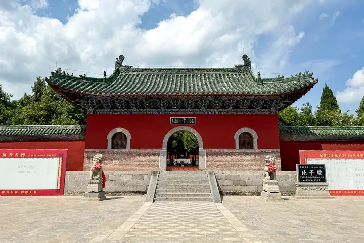 The main gate hall of Bi Gan Temple, Weihui ·
 Plan your visit
Getting there
Weihui is about 15 km in a straight line from central Xinxiang. Search for 卫辉市 in a map app to find stations and your accommodation.
Where to stay →Build your route
Start with Bi Gan Temple. The linked place guides have entrance and visit details.
Continue with Xinxiang →More in Xinxiang
Sources & geographic information
Administrative names and parent areas: Official geographic directory · Reference date 2026-09-06.
Some facts checked against 卫辉市 — Wikipedia contributors, CC BY-SA 4.0.
Some facts checked against 比干庙 — Wikipedia contributors, CC BY-SA 4.0.
Photo: Bi Gan Temple · Windmemories · CC BY-SA 4.0. Full frame retained; proportionally resized and converted to WebP. No retouching or changes to the photographed subject. Card displays may crop the view.

Map data © OpenStreetMap contributors. Pins mark approximate centres, not entrances or boundaries.