


Get to know Hancheng

Photo adjustments
Full frame retained; proportionally resized and converted to WebP. No retouching or changes to the photographed subject. Card displays may crop the view.
- Administrative area
- County-level city · 县级市
- Part of
- Weinan
- Chinese name
- 韩城市
- Local areas
- County-level city guide
Area & population
- Area in the source
- 1,621.00 km²
- Population · 2018
- 397,020
Source: cited geographic source, as of the dates shown.
Setting and landscape
The west of the city is mountains and hills, while the east is plain and valley pressed against the Yellow River. Longmen (龙门), the "Dragon Gate" in the north-east, is the traditional name for the narrowest stretch of the river between Hancheng and Hejin, linked to the legend of Yu the Great (大禹) guiding the river. Li Yuan (李渊) at the end of the Sui and Li Zicheng (李自成) at the end of the Ming both crossed the river here.
History
Known in ancient times as Longmen, the area was the Han marquisate (韩侯国) under the Western Zhou. Qin set up Xiayang County (夏阳县) here in 327 BC, and the Sui created Hancheng County in 598. It became a city in January 1984 and a national historic and cultural city in 1986. Hancheng is the home town of the historian Sima Qian (司马迁).
What to see
The city government counts 208 protected heritage sites, 17 of them national and 33 provincial. The national list includes the Tomb and Shrine of Sima Qian (司马迁墓和祠), the Dayu Temple (韩城大禹庙), the Confucian Temple (韩城文庙) and the City God Temple (韩城城隍庙). The old town (韩城古城) keeps many historic streets and houses. Sights run south to north: the Sima Qian shrine and tomb, the old town and Dangjia Village, then Longmen.
Dangjia Village (党家村), in Xizhuang (西庄镇) about 9 km north-west of the city and 3.5 km from the Yellow River, lies on the north side of the Mishui (泌水) valley. Its houses are mainly Ming and Qing courtyard homes, more than 100 of them intact, along some twenty streets paved with stone slabs or pebbles; in the Qing it was nicknamed "Little Hancheng". It became a national protected site in 2001 and a historic and cultural village in 2003. The Zhou-dynasty site at Liangdai Village (梁带村两周遗址) was named one of China's ten major archaeological discoveries of 2005.
Food and local products
Hancheng's Dahongpao Sichuan pepper (韩城大红袍花椒) was the first Sichuan pepper in China to become a national geographical indication product. The city's most representative traditions include door-lintel inscriptions (门楣题字), baimian luogu gong-and-drum ensembles (百面锣鼓), shuashenlou (耍神楼) and yangge (秧歌) dancing.
Getting oriented
Hancheng is a little over 210 km from Xi'an. The Beijing–Kunming expressway, National Highways 108 and 327, the Yellow River road, and the Houma–Xi'an (侯西铁路) and Haoji (浩吉铁路) railways cross the city, and the Yumenkou Yellow River bridge links it to Shanxi.
Highlights
- Tomb and Shrine of Sima Qian 司马迁墓和祠: Tomb and shrine of the historian; national protected site.
- Dangjia Village 党家村: Over 100 intact courtyard houses, mainly Ming and Qing; national protected site since 2001.
- Hancheng Confucian Temple 韩城文庙: On the national protected list.
- Longmen 龙门: Traditional name for the narrowest stretch of the Yellow River around Hancheng and Hejin.
- Dahongpao Sichuan pepper 韩城大红袍花椒: First Sichuan pepper with national geographical indication protection.
Sources for this guide
韩城概况--韩城市人民政府 · Hancheng Municipal People's Government
党家村 - 维基百科 · Wikipedia (Chinese) · CC BY-SA 4.0
韩城市 - 维基百科 · Wikipedia (Chinese) · CC BY-SA 4.0
Original English written from the listed sources and checked sentence by sentence against quoted extracts by a separate reviewer. Updated 2026-09-25.
Explore Hancheng
Core places to explore, with English and Chinese names.
Places to explore around Hancheng
Courtyard houses and pagoda in Dangjia Village · 党家村 Photograph date recorded by the source: 25 July 2006.Dangjia Village党家村
Dangjia Village preserves a concentrated group of Ming and Qing courtyard houses in a valley northwest of Hancheng. Stone-paved lanes weave between the enclosed homes, making the relationship between street, doorway and inner…
Read the place guide →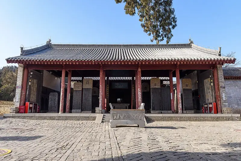 Shrine and Tomb of Sima Qian (司马迁祠墓), Hancheng. Photograph: "Temple of Sima Qian, Hancheng (20250113111702)".
Shrine and Tomb of Sima Qian司马迁祠墓
The shrine and tomb of Sima Qian (司马迁祠墓) stand at Zhichuan town in Hancheng, Weinan, Shaanxi. A People's Daily Overseas Edition essay describes the building group climbing the slope from its foot to the top, hugging the cliff, with the Yellow River to the east and Liang Mountain to the west.
Read the place guide → Visitors at the gate of Beiying Temple within Hancheng Old Town, Hancheng · 韩城古城北营庙山门,韩城市 Source-recorded photograph date: 2024-10-02 12:51:05.
Hancheng Ancient City韩城古城
Hancheng old city (韩城古城) is the walled historic town of Hancheng in Weinan, Shaanxi, between the Longmen gorge upstream and the Zhichuan ferry downstream.
Read the place guide →Plan your visit
Getting there
Hancheng is about 135 km in a straight line from central Weinan. Search for 韩城市 in a map app to find stations and your accommodation.
Where to stay →Build your route
Dangjia Village and Shrine and Tomb of Sima Qian are both listed here. The linked place guides have entrance and visit details.
Continue with Weinan →More in Weinan
Sources & geographic information
Administrative names and parent areas: Official geographic directory · Reference date 2026-09-06.
Some facts checked against 党家村 — Wikipedia contributors, CC BY-SA 4.0.
Some facts checked against 韩城市 — Wikipedia contributors, CC BY-SA 4.0.
Photo: Dangjia Village · User Cshcts on zh.wikipedia · CC BY-SA 3.0. Full frame retained; proportionally resized and converted to WebP. No retouching or changes to the photographed subject. Card displays may crop the view.

Photo: Shrine and Tomb of Sima Qian · N509FZ · CC BY-SA 4.0. Full frame retained; EXIF orientation normalized, proportionally resized to at most 800 pixels and converted to WebP. No generated pixels or subject changes. Cards may crop the display.

Photo: Hancheng Ancient City · Liuxingy · CC BY-SA 4.0. Full frame retained; proportionally resized and converted to WebP. No retouching or changes to the photographed subject. Card displays may crop the view.

Map data © OpenStreetMap contributors. Pins mark approximate centres, not entrances or boundaries.