


Get to know Penghu County
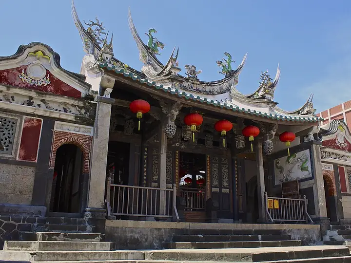
Photo adjustments
Full-frame source proportionally resized and converted to WebP for display. No subject alteration. Source-supplied marks and edits remain; cards may crop the view.
- Administrative area
- County / city · 縣市
- Part of
- Taiwan
- Chinese name
- 澎湖縣
- Local areas
- 6 local areas
Area & population
- Area in the source
- 141.05 km²
- Administrative seat
- Magong City
Source: cited geographic source, as of the dates shown.
The Penghu islands first appear in the historical record in the Tang dynasty and were inhabited by Chinese people under the Song dynasty, during which they were attached to Jinjiang County of Fujian. The archipelago was formally incorporated as an administrative unit of China in 1281 under Tong'an County. It continued to be controlled by Imperial China with brief European occupations by the Dutch (1622–1624) and Second French colonial empire (1885), until it was ceded to the Japanese in 1895. The Surrender of Japan in 1945 ended its rule of the archipelago, which has since been governed by the Republic of China (ROC). Under the terms of the Sino-American Mutual Defense Treaty and the subsequent Taiwan Relations Act between the ROC and the United States, Penghu is defined and geographically acknowledged as part of Taiwan.
Tourism
The Penghu National Scenic Area was established in the early 1990s, comprising most of the islands and islets of the archipelago. Tourism has since become one of the main sources of income of the county.
Historical sites include Central Street, Erdai Art Hall, Tianhou Temple, Four-eyed Well, Penghu Reclamation Hall, Qimei Lighthouse, Xiyu Eastern Fort, Jinguitou Fortress and Xiyu Western Fort. Museums in the county are Chuwan Crab Museum, Ocean Resources Museum, Chang Yu-sheng Memorial Museum and Penghu Living Museum. Other attractions in the county include the Double-Heart of Stacked Stones, Fenggui Cave, Little Taiwan, Whale Cave, Xiaomen Geology Gallery and South Penghu Marine National Park.
Explore Penghu County
Core places to explore, with English and Chinese names.
Penghu 澎湖
Penghu Tianhou Temple 澎湖天后宮
Twin Hearts Stone Weir 双心石沪
Huazhai Traditional Village, Zhongshe 中社古厝
Jibei Sand Spit 吉贝沙尾
Penghu Great Bridge 澎湖跨海大桥
Erkan Traditional Village 二崁传统聚落
Chixi Columnar Basalt 池西玄武岩
Penghu Tianhou Temple & Central Old Street 澎湖天后宫与中央老街
Penghu Living Museum 澎湖生活博物馆
Magong City 馬公市
Huxi Township 湖西鄉
Baisha Township 白沙鄉
Xiyu Township 西嶼鄉
Wangan Township 望安鄉
Cimei Township 七美鄉
Places to explore around Penghu County
 Chixi columnar basalt on Xiyu Island, Penghu · 澎湖西屿池西柱状玄武岩 Source-recorded photograph date: 2019-08-14 13:04:08.
Penghu澎湖
Penghu is an archipelago, so a good itinerary distinguishes the road-connected main islands from destinations requiring another boat. Magong’s old streets and Tianhou Temple provide a cultural starting point. The cross-sea…
Read the place guide →Front facade of Penghu Tianhou Temple in Magong · 马公澎湖天后宫正面 Source-recorded photograph date: 2017-06-22 14:23:39.Penghu Tianhou Temple澎湖天后宮
Penghu Tianhou Temple stands in Magong’s historic centre and reflects the islands’ close relationship with seafaring and Mazu worship. Its layered halls contain detailed timber and stone craftsmanship. Begin at the front…
Read the place guide →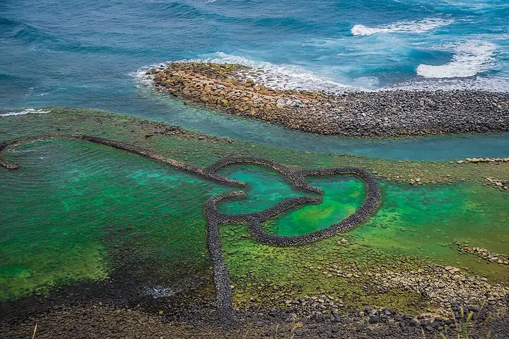 The Twin Heart Stone Weir off Cimei, Penghu · 澎湖七美双心石沪 Source-recorded photograph date: Taken on 21 July 2015.
Twin Hearts Stone Weir双心石沪
The Twin Hearts Stone Weir (双心石沪) is a traditional tidal fishing structure off Qimei Island.
Read the place guide → A lane between traditional houses at Zhongshe, Wangan · 望安中社古厝之间的巷道 Source-recorded photograph date: 2019-09-14 13:26:27.
Huazhai Traditional Village, Zhongshe中社古厝
Zhongshe's old houses (中社古厝) belong to Huazhai, a traditional settlement on Wang'an Island.
Read the place guide →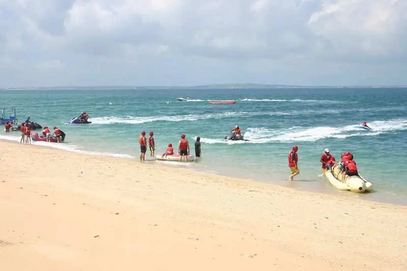 Jibei Sand Spit · 吉贝沙尾
Jibei Sand Spit吉贝沙尾
Jibei Sand Spit (吉贝沙尾) projects into the sea from the southwestern side of Jibei Island in northern Penghu.
Read the place guide →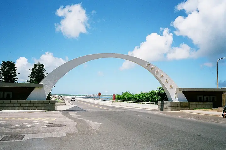 The entrance arch of Penghu Great Bridge · 澎湖跨海大桥入口拱门 Source-recorded photograph date: 2014-08-05 00:19:57.
Penghu Great Bridge澎湖跨海大桥
Penghu Great Bridge (澎湖跨海大桥) connects Baisha and Xiyu across the Houmen Channel.
Read the place guide →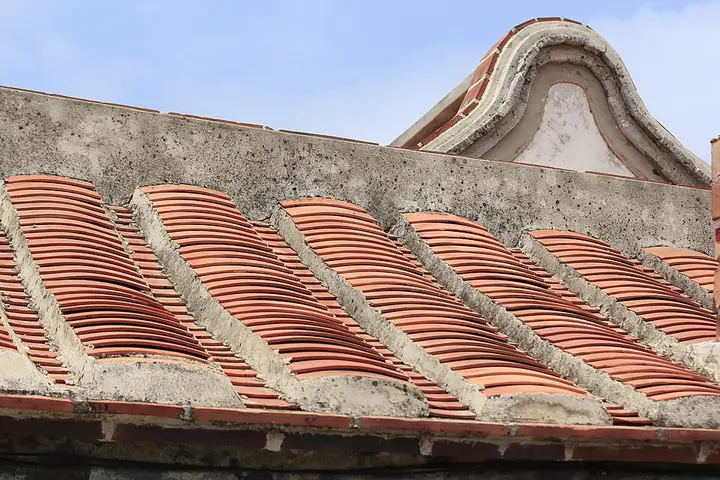 Traditional tiled-roof details in Erkan Village, Xiyu · 西屿二崁聚落古厝的瓦屋顶细节 Source-recorded photograph date: 2011-07-09 11:15:48.
Erkan Traditional Village二崁传统聚落
Erkan Traditional Village (二崁传统聚落) is a historic settlement on Xiyu Island, with a strong Chen-family association.
Read the place guide →Columnar basalt formations at Chixi, Penghu · 澎湖池西柱状玄武岩 Source-recorded photograph date: 2019-08-14 13:04:08.Chixi Columnar Basalt池西玄武岩
Chixi Columnar Basalt (池西玄武岩) is a volcanic-rock exposure on Xiyu's western coast.
Read the place guide →Exterior of Penghu Tianhou Temple in Magong · 马公澎湖天后宫外观 Source-recorded photograph date: 2017-06-22 14:23:39.Penghu Tianhou Temple & Central Old Street澎湖天后宫与中央老街
Penghu Tianhou Temple and Central Old Street (澎湖天后宫与中央老街) sit within Magong's historic core.
Read the place guide →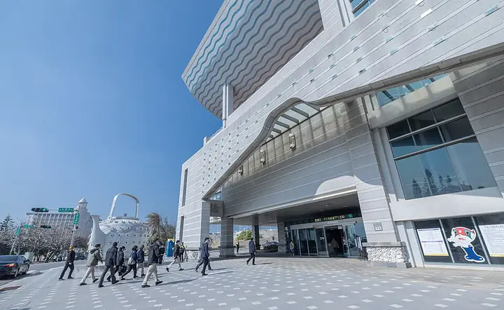 Entrance and exterior of Penghu Living Museum · 澎湖生活博物馆入口与外观 Source-recorded photograph date: 2025-01-21 13:35:20.
Penghu Living Museum澎湖生活博物馆
Penghu Living Museum (澎湖生活博物馆) in Magong introduces how people have lived in the islands, using objects, documents, models and reconstructed settings.
Read the place guide →Local life & food
Penghu County local specialties
澎湖縣特色美食 · 12 specialties to discover
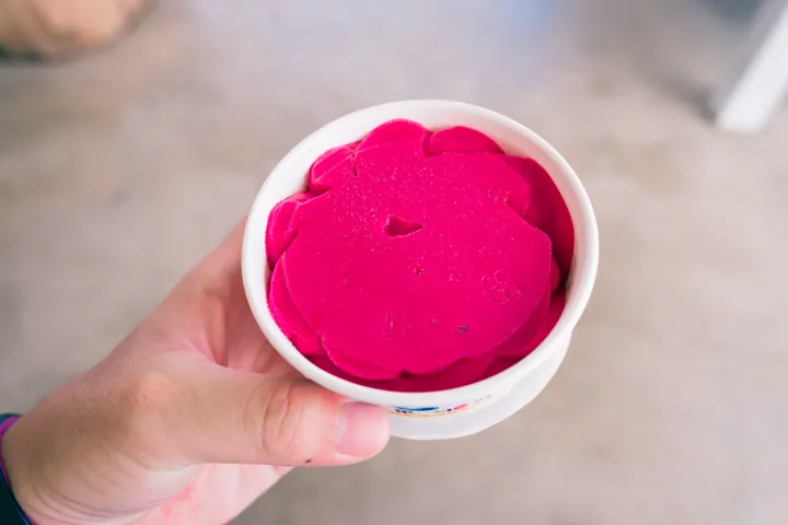 Cactus Fruit Ice Dessert 仙人掌冰
Cactus Fruit Ice Dessert (仙人掌冰) is a purple-red, sweet-and-tangy frozen dessert in Penghu (澎湖), Taiwan (台湾). One local serving combines cactus-fruit jam, crushed ice and a scoop of cactus ice cream.
Read the dish guide →
Photo adjustments
Full frame retained; proportionally resized and converted to WebP. No retouching or changes to the photographed subject. Card displays may crop the view.
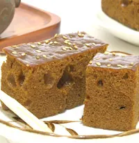 Brown Sugar Cake 黑糖糕
Brown Sugar Cake (黑糖糕) is a Penghu (澎湖) sweet associated with the islands’ rice-based fa gao (發糕) cakes and their use as ritual offerings.
Source ↗Read the dish guide →
Photo adjustments
Resized and WebP compressed; subject not altered.
 Baby Squid Vermicelli 小管面线AI illustration · AI 示意图(仅供参考,非实拍)
Baby Squid Vermicelli (小管面线) is listed among the local specialties of Penghu County, Taiwan. The term 面 points to noodles or flour-based food.
Read the dish guide → Cuttlefish Balls 花枝丸AI illustration · AI 示意图(仅供参考,非实拍)
Cuttlefish Balls (花枝丸) are a Penghu (澎湖) seafood snack. The islands’ tourism account describes freshly fried balls served on skewers, with cuttlefish in the mixture.
Read the dish guide →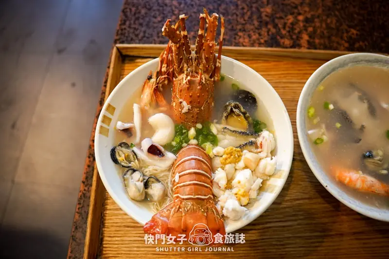 Seafood Congee 海鲜粥
Seafood Congee (海鲜粥) is listed among the local specialties of Penghu County, Taiwan. The name includes 海鲜 (seafood). The term 粥 points to congee.
Read the dish guide →Photo adjustments
EXIF orientation normalized; resized without changing aspect ratio; converted to WebP. No subject edits.
 Fengru Herbal Tea 风茹茶AI illustration · AI 示意图(仅供参考,非实拍)
Fengru Herbal Tea (风茹茶) is an herbal infusion from Penghu (澎湖), made with fengru grass (風茹草), Glossogyne tenuifolia. The plant is native to the islands and tolerates drought, wind, salt and poor soil.
Read the dish guide → Deep-Fried Filled Glutinous Rice Balls 炸枣
Deep-Fried Filled Glutinous Rice Balls (炸枣) appears in the local food directory for Taiwan. The Chinese introduction below explains the named food and its preparation in the linked culinary reference.
Source ↗Read the dish guide →Photo adjustments
EXIF orientation normalized; resized without changing aspect ratio; converted to WebP. No subject edits.
 Winter Melon Cake 冬瓜糕AI illustration · AI 示意图(仅供参考,非实拍)
Winter Melon Cake (冬瓜糕) is a flaky pastry filled with cooked-down winter melon, a speciality of the Penghu (澎湖) islands. Its shape resembles a sun cake (太阳饼), but it is thicker.
Read the dish guide →All dish names · 全部菜名 (12)
- Cactus Fruit Ice Dessert · 仙人掌冰
- Brown Sugar Cake · 黑糖糕
- Baby Squid Vermicelli · 小管面线
- Cuttlefish Balls · 花枝丸
- Seafood Congee · 海鲜粥
- Fengru Herbal Tea · 风茹茶
- Deep-Fried Filled Glutinous Rice Balls · 炸枣
- Winter Melon Cake · 冬瓜糕
- Rock Oyster Omelet · 石蚵煎
- Small Turban Snails · 珠螺
- Penghu Stir-Fried Luffa with Clams · 澎湖丝瓜炒蛤蜊
- Anchovy Fry Stir-Fried with Peanuts · 丁香鱼炒花生
More dishes from across Taiwan are in the Taiwan food guide.
Townships, districts & local cities in Penghu County
6 areas belong directly to Penghu County.
6 areas
Magong City 馬公市
Magong (Makō, Makung) is a county-administered city and seat of Penghu County, Taiwan located on Penghu's main island, bordering Huxi Township to the east.
Explore the area →Rural townshipHuxi Township 湖西鄉
Huxi Township is a rural township in Penghu County, Taiwan. It is located on the eastern part of the Penghu Main Island and is the largest township in Penghu County.
Explore the area →Rural townshipBaisha Township 白沙鄉
Baisha Township is a rural township in Penghu County, Taiwan. It is located to the north of Penghu Main Island and linked to Siyu Island by the Penghu Trans-Oceanic Bridge, which at 2.5 km (1.6 mi) long is…
Explore the area →Rural townshipXiyu Township 西嶼鄉
Xiyu Township (alternatively Siyu, Hsiyu, Si Island, Hsi Island) is a rural township in Penghu County, Taiwan. It has a population of 8,301 and an area of 18.7148 square kilometres.
Explore the area →Show fewer areas
Wangan Township 望安鄉
Wangan Township / Wang-an Township is a rural township in Penghu County (the Pescadores), Taiwan. It is the second smallest township in Penghu County after Cimei Township.
Explore the area →Rural townshipCimei Township 七美鄉
Cimei Township (Qimei Township, Chimei Township) is a rural township in Penghu County, Taiwan. The island is the fifth largest in Penghu and the southernmost island in the group.
Explore the area →No areas match this name.
Plan your visit
Getting there
Search for 澎湖縣 in a map app to find stations and your accommodation.
Where to stay →Build your route
Penghu and Penghu Tianhou Temple are about 1 km apart in a straight line. The linked place guides have entrance and visit details.
Continue with Taiwan →More in Taiwan
Sources & geographic information
Administrative names and parent areas: Official geographic directory · Reference date 2026-09-06.
Background text adapted from Penghu — Wikipedia contributors, under CC BY-SA 4.0. Text has been shortened and reorganized; source revision 1371557890.
Photo: Penghu · Rick888chen · CC BY-SA 4.0. Full-frame source proportionally resized and converted to WebP for display. No subject alteration. Source-supplied marks and edits remain; cards may crop the view.

Photo: Penghu Tianhou Temple · TroyJiang · CC BY-SA 4.0. Full-frame source proportionally resized and converted to WebP for display. No subject alteration. Source-supplied marks and edits remain; cards may crop the view.

Photo: Twin Hearts Stone Weir · Zeze0729 · CC BY-SA 3.0. Full-frame source proportionally resized and converted to WebP for display. No subject alteration. Source-supplied marks and edits remain; cards may crop the view.

Photo: Huazhai Traditional Village, Zhongshe · Jgfhhgf942zo · CC BY-SA 4.0. Full-frame source proportionally resized and converted to WebP for display. No subject alteration. Source-supplied marks and edits remain; cards may crop the view.

Photo: Jibei Sand Spit · Source photographer · License not provided. EXIF orientation normalized; resized without changing aspect ratio; converted to WebP. No subject edits.
Photo: Penghu Great Bridge · Mark Yang · CC BY-SA 2.0. Full-frame source proportionally resized and converted to WebP for display. No subject alteration. Source-supplied marks and edits remain; cards may crop the view.

Photo: Erkan Traditional Village · Perryn1258 · CC BY-SA 4.0. Full-frame source proportionally resized and converted to WebP for display. No subject alteration. Source-supplied marks and edits remain; cards may crop the view.

Photo: Chixi Columnar Basalt · Rick888chen · CC BY-SA 4.0. Full-frame source proportionally resized and converted to WebP for display. No subject alteration. Source-supplied marks and edits remain; cards may crop the view.
Photo: Penghu Tianhou Temple & Central Old Street · TroyJiang · CC BY-SA 4.0. Full-frame source proportionally resized and converted to WebP for display. No subject alteration. Source-supplied marks and edits remain; cards may crop the view.
Photo: Penghu Living Museum · 總統府 · CC BY 2.0. Full-frame source proportionally resized and converted to WebP for display. No subject alteration. Source-supplied marks and edits remain; cards may crop the view.

Map data © OpenStreetMap contributors. Pins mark approximate centres, not entrances or boundaries.