


Get to know Burqin County

Photo adjustments
Full frame retained; proportionally resized and converted to WebP. No retouching or changes to the photographed subject. Card displays may crop the view.
- Administrative area
- County · 县
- Part of
- Altay Prefecture
- Chinese name
- 布尔津县
- Local areas
- County guide
Area & population
- Area in the source
- 10,344.99 km²
- Population · 2020
- 72,894
- Administrative seat
- Burqin Town
Source: cited geographic source, as of the dates shown.
Setting and landscape
The land falls from north-east to south-west in three bands: high and middle mountains in the north, low hills and river valleys in the middle, and semi-desert low mountains in the south. Friendship Peak (友谊峰), the highest point of the Altai range, is in the north. Two river systems drain the county, the Irtysh (额尔齐斯河) and the Burqin. Summers are dry and hot and winters severe; rainfall is low, evaporation high and the gap between day and night temperatures wide.
History
After the Qing conquest of the Dzungars the area came under the Kobdo Councillor (科布多参赞大臣) and was grazing land for the Altai Uriankhai (阿尔泰乌梁海). In 1914 a Burqin administrative bureau was split off from Chenghua County (承化县), named for its position on the Burqin River, and in 1919 Burqin became a full county.
What to see
The county government places Kanas in the north of the county, 150 km from the county town. The alpine lake drains to the Arctic Ocean, unlike most Chinese rivers; its surface sits at 1,374 m, it covers 44.78 km² and it reaches about 196 m deep. It was approved as a national 5A scenic area in 2007. The Tuluke rock paintings (吐鲁克岩画), carved on glacier-smoothed rock on the east shore of the first of its six bays, show horses, sheep, wolves, dogs and deer.
Hemu (禾木) is a village of log houses, log fences and log pens set in open grassland ringed by forest; it is home mainly to Tuvans (图瓦人) with some Kazakhs, and Russians also lived there from the 1920s to the 1980s. The county explains the name as the Tuvan word for 'fat'. Closer to the county town, Wucaitan (五彩滩), a national 4A scenic area, lies on terraces on the north bank of the Irtysh, 24 km from town; the Aketubieke yardang landforms (阿克吐别克雅丹地貌), also on the Irtysh north-bank terraces in Woyimoke Township (窝依莫克乡), are cut into red, pale yellow and pale green mudstone and conglomerate. On the eastern edge of town is the tomb of the Kazakh folk composer Baishanbu Dunanbai (白山布·杜南拜), credited with originating pieces for the dombra (冬不拉).
Food and local products
Hemu honey (禾木蜂蜜) comes from bees working the flowers of the taiga forest. Kanas melons (喀纳斯蜜瓜) are grown in Woyimoke along the Kanas tourist road and are known for high sugar. Youtazi (油塔子) are pagoda-shaped steamed buns: leavened dough is rolled thin, spread with rendered sheep-tail fat, salt and Sichuan pepper powder, rolled up, twisted into a tower and steamed for half an hour.
Highlights
- Kanas Lake 喀纳斯湖: Arctic-drainage alpine lake 1,374 m above sea level, a national 5A scenic area since 2007.
- Hemu Village 禾木村: Log-built village of Tuvan and Kazakh families on open grassland.
- Wucaitan 五彩滩: National 4A scenic area on the north-bank terraces of the Irtysh, 24 km from the county town.
- Tuluke Rock Paintings 吐鲁克岩画: Animal carvings on a glacier-smoothed rock at Kanas Lake's first bay.
- Youtazi 油塔子: Pagoda-shaped steamed buns layered with sheep-tail fat and Sichuan pepper.
Sources for this guide
布尔津县 - 维基百科,自由的百科全书 · Chinese Wikipedia · CC BY-SA 4.0
喀纳斯 · Burqin County People's Government
禾木村 · Burqin County People's Government
Original English written from the listed sources and checked sentence by sentence against quoted extracts by a separate reviewer. Updated 2026-09-25.
Explore Burqin County
Core places to explore, with English and Chinese names.
Places to explore around Burqin County
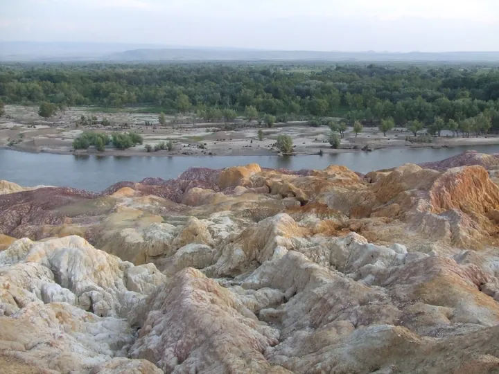 The multicoloured eroded cliffs of Wucaitan (Five-Colour Beach) beside the Irtysh River, Burqin County · 布尔津县五彩滩,额尔齐斯河畔五彩丘陵 Source-recorded photograph date: Taken on 3 July 2007.
Five-Colour Beach五彩滩
Wucaitan (五彩滩, 'Five-Colour Beach') is a national AAAA-grade riverbank scenic area known for yardang landform on the north bank of the Irtysh, about twenty-four kilometres north-west of Burqin county town, Xinjiang.
Read the place guide →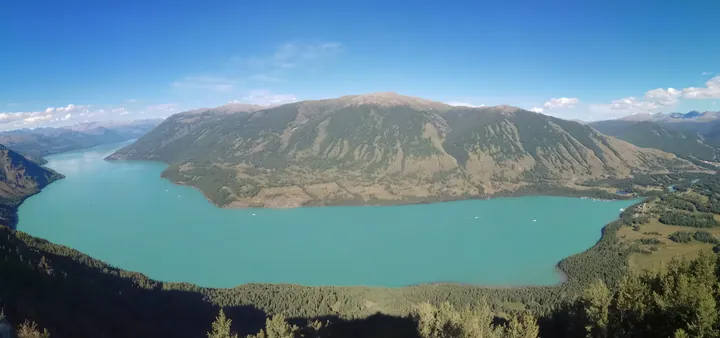 Kanas Lake seen from a viewing platform above, with forested mountains around its turquoise water · 从观景台俯瞰喀纳斯湖,湖水碧绿,四周群山环绕 Source-recorded photograph date: 2018-08-06.
Kanas Scenic Area喀纳斯
Scenic area in the Altai Mountains of Burqin County with a deep glacial lake, Siberian taiga, curving river bays and Tuvan villages.
Read the place guide →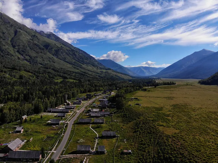 An elevated view down the 禾木 valley: a scattered village of dark log houses with plank roofs along a road, green meadows and a strip of crops at the right, dense spruce forest and steep slopes at the left, and snow-streaked mountains closing the valley under a deep blue sky streaked with cirrus.
Hemu Village禾木
Hemu (禾木) is a village in Hemu Kanas Mongol township, Burqin County, Altay Prefecture, Xinjiang, on the Hemu River and surrounded by forest and grassland.
Read the place guide →Plan your visit
Getting there
Burqin County is about 110 km in a straight line from central Altay Prefecture. Search for 布尔津县 in a map app to find stations and your accommodation.
Where to stay →Build your route
Five-Colour Beach and Kanas Scenic Area are both listed here. The linked place guides have entrance and visit details.
Continue with Altay Prefecture →More in Altay Prefecture
Sources & geographic information
Administrative names and parent areas: Official geographic directory · Reference date 2026-09-06.
Some facts checked against 布尔津县 — Wikipedia contributors, CC BY-SA 4.0.
Photo: Five-Colour Beach · Nyx Ning · CC BY-SA 3.0. Full frame retained; proportionally resized and converted to WebP. No retouching or changes to the photographed subject. Card displays may crop the view.

Photo: Kanas Scenic Area · Newbamboo · CC BY-SA 4.0. Full frame retained; proportionally resized and converted to WebP. No retouching or changes to the photographed subject. Card displays may crop the view.

Photo: Hemu Village · Yanxutong1215 · CC BY-SA 4.0. Full frame retained; proportionally resized and converted to WebP. No retouching or changes to the photographed subject. Card displays may crop the view.

Map data © OpenStreetMap contributors. Pins mark approximate centres, not entrances or boundaries.