


Get to know Altay Prefecture

Photo adjustments
Full frame retained; proportionally resized and converted to WebP. No retouching or changes to the photographed subject. Card displays may crop the view.
- Administrative area
- Prefecture · 地区
- Part of
- Xinjiang
- Chinese name
- 阿勒泰地区
- Local areas
- 7 local areas
Area & population
- Area in the source
- 117,710.00 km²
- Population · 2020 census
- 648,173
- Administrative seat
- Altay City
Source: cited geographic source, as of the dates shown.
Altay is considered the birthplace of skiing, based on 10,000 to 30,000 year old cave paintings depicting skiers.
Explore Altay Prefecture
Core places to explore, with English and Chinese names.
Kanas Lake 喀纳斯湖
Hemu Village 禾木村
Koktokay 可可托海
Ulungur Lake 乌伦古湖
Grassland Stone City 草原石城
Baihaba Village 白哈巴村
Baisha Lake 白沙湖
Birch Forest Scenic Area 白桦林景区
Keketuohai No. 3 Mine Pit and Geology Exhibition 可可托海三号矿坑与地质陈列
Five-Colour Beach 五彩滩
Kanas Scenic Area 喀纳斯
Hemu Village 禾木
Altay-Hemu Highway Open Section 阿禾公路正规开放路段
Jiangjunshan International Ski Resort 将军山国际滑雪度假区
Altay City 阿勒泰市
Burqin County 布尔津县
Fuyun County 富蕴县
Fuhai County 福海县
Habahe County 哈巴河县
Qinggil County 青河县
Jeminay County 吉木乃县
Places to explore around Altay Prefecture
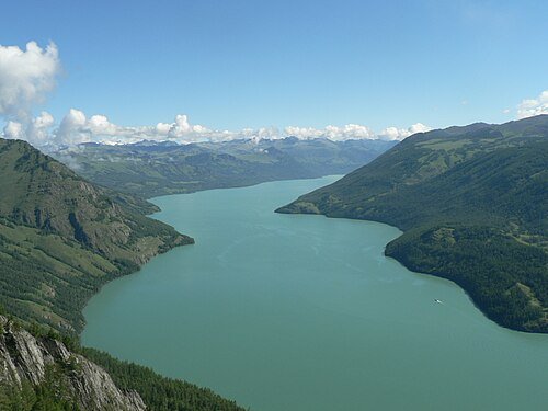 Xinjiang Kanas National Geopark · 喀纳斯
Kanas Lake喀纳斯湖
Kanas lies in a forested valley in the Altai Mountains, with the lake flowing into a river landscape of bends and smaller viewing areas. The lakeshore, Three Bays and Guanyutai offer different perspectives and require different…
Read the place guide →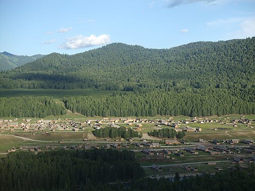 Hemu Village · 禾木村
Hemu Village禾木村
Hemu’s timber houses sit in a broad mountain valley around the Hemu River, with birch woodland adding strong seasonal colour. The public lanes provide a close view of the settlement, while Haden viewing platform shows the…
Read the place guide →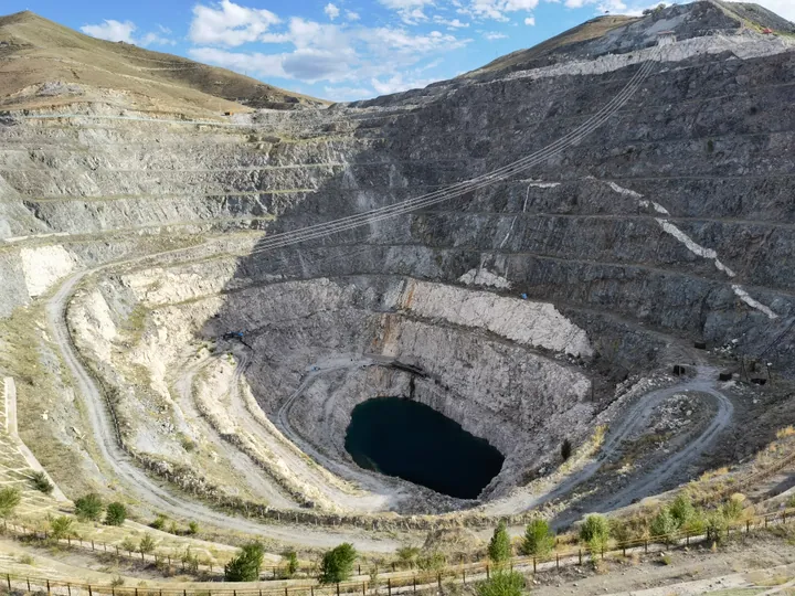 The No. 3 open-pit pegmatite mine at the Koktokay mining park, Fuyun County · 富蕴县可可托海三号矿坑 Source-recorded photograph date: 2021-06-23 19:19:02.
Koktokay可可托海
Koktokay combines two distinct visitor experiences: the granite peaks and river scenery of the Irtysh gorge, and the mining history of the former rare-metal settlement. Shenzhong Mountain is a recognisable natural landmark…
Read the place guide →Southeastern shore of Ulungur Lake, photographed in 2008 · 乌伦古湖东南岸 Photograph date recorded by the source: 5 September 2008, 10:36:59.Ulungur Lake乌伦古湖
Ulungur is a large lake system near Fuhai, comprising the main Buluntuo water body and smaller Jili Lake linked by a channel. Fishing and wetland habitats are central to its regional character. The broad shores provide a…
Read the place guide →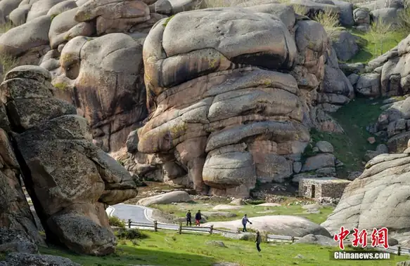 Grassland Stone City · 草原石城
Grassland Stone City草原石城
Caoyuan Shicheng (草原石城, 'Grassland Stone City') is a granite stone-formation area in Jeminay County, Altay Prefecture, Xinjiang, which also contains the Tongtiandong Palaeolithic cave site.
Read the place guide → Baihaba Village · 白哈巴村
Baihaba Village白哈巴村
Baihaba village (白哈巴村) is a village on China's border with Kazakhstan in Habahe County, Altay Prefecture, Xinjiang.
Read the place guide → AI illustration · AI 示意图(仅供参考,非该地点实拍)
Baisha Lake白沙湖
Baisha Lake (白沙湖) is a small desert lake ringed by sand dunes in Habahe County, Altay Prefecture, Xinjiang, and the core of the 10th Division's 185th Regiment scenic area.
Read the place guide →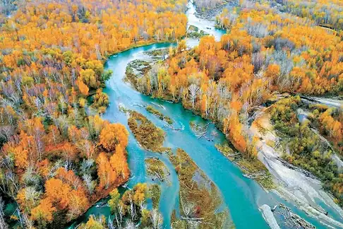 Birch Forest Scenic Area · 白桦林景区
Birch Forest Scenic Area白桦林景区
The Birch Forest Scenic Area (白桦林景区) is a naturally grown birch belt beside the Haba River, four kilometres from the Habahe county seat in Altay Prefecture, Xinjiang.
Read the place guide →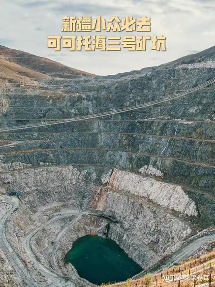 Keketuohai No. 3 Mine Pit and Geology Exhibition · 可可托海三号矿坑与地质陈列
Keketuohai No. 3 Mine Pit and Geology Exhibition可可托海三号矿坑与地质陈列
The Keketuohai No. 3 Mine Pit and its geological exhibition hall (可可托海三号矿坑与地质陈列) are in Keketuohai town, Fuyun County, Altay Prefecture, Xinjiang.
Read the place guide →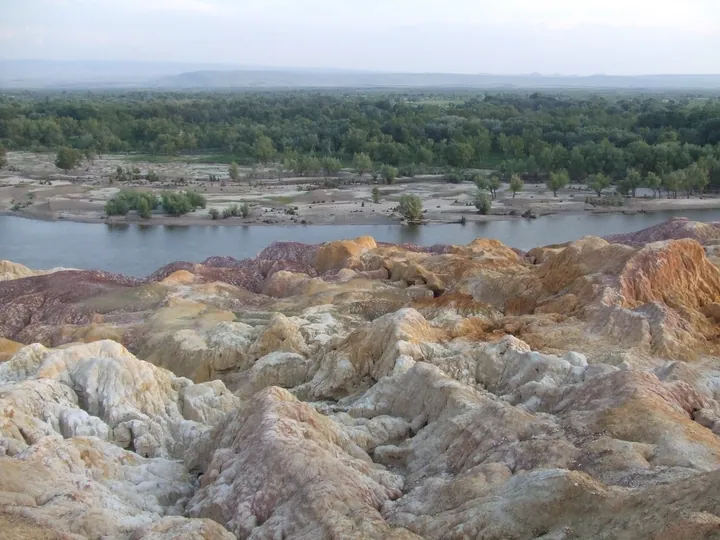 The multicoloured eroded cliffs of Wucaitan (Five-Colour Beach) beside the Irtysh River, Burqin County · 布尔津县五彩滩,额尔齐斯河畔五彩丘陵 Source-recorded photograph date: Taken on 3 July 2007.
Five-Colour Beach五彩滩
Wucaitan (五彩滩, 'Five-Colour Beach') is a national AAAA-grade riverbank scenic area known for yardang landform on the north bank of the Irtysh, about twenty-four kilometres north-west of Burqin county town, Xinjiang.
Read the place guide →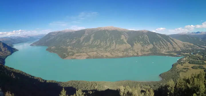 Kanas Lake seen from a viewing platform above, with forested mountains around its turquoise water · 从观景台俯瞰喀纳斯湖,湖水碧绿,四周群山环绕 Source-recorded photograph date: 2018-08-06.
Kanas Scenic Area喀纳斯
Scenic area in the Altai Mountains of Burqin County with a deep glacial lake, Siberian taiga, curving river bays and Tuvan villages.
Read the place guide →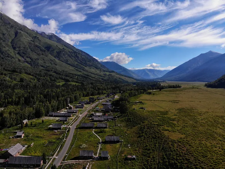 An elevated view down the 禾木 valley: a scattered village of dark log houses with plank roofs along a road, green meadows and a strip of crops at the right, dense spruce forest and steep slopes at the left, and snow-streaked mountains closing the valley under a deep blue sky streaked with cirrus.
Hemu Village禾木
Hemu (禾木) is a village in Hemu Kanas Mongol township, Burqin County, Altay Prefecture, Xinjiang, on the Hemu River and surrounded by forest and grassland.
Read the place guide →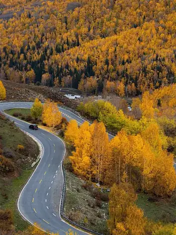 Altay-Hemu Highway Open Section · 阿禾公路正规开放路段
Altay-Hemu Highway Open Section阿禾公路正规开放路段
The Ahe highway (阿禾公路) is a 209-kilometre road from Altay City to Hemu village in the Kanas scenic area, in Altay Prefecture, Xinjiang, which opened to traffic on 30 June 2025.
Read the place guide → Jiangjunshan International Ski Resort · 将军山国际滑雪度假区
Jiangjunshan International Ski Resort将军山国际滑雪度假区
Jiangjunshan International Ski Resort (将军山国际滑雪度假区) is a city ski area 1.6 kilometres from the centre of Altay City, Altay Prefecture, Xinjiang, which the regional culture and tourism department lists as a 5S-grade ski area.
Read the place guide →Local life & food
Altay Prefecture local specialties
阿勒泰地区特色美食 · 11 specialties to discover
 Smoked horse sausage 熏马肠AI illustration · AI 示意图
Slices are firm and rich, with a smoky, savory aroma and a distinctive meat flavor. Thin pieces make its concentrated character easier to appreciate.
Source ↗Read the dish guide →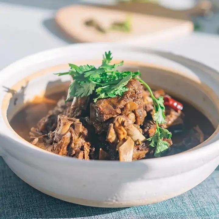 Altay Fat-Tailed Sheep Hand-Grabbed Meat 阿勒泰大尾羊手抓肉
Altay Fat-Tailed Sheep Hand-Grabbed Meat (阿勒泰大尾羊手抓肉) is bone-in mutton from the Altay fat-tailed sheep of Altay Prefecture (阿勒泰地区) in northern Xinjiang.
Read the dish guide →Photo adjustments
EXIF orientation normalized; resized without changing aspect ratio; converted to WebP. No subject edits.
 Burqin Grilled Fish 布尔津烤鱼AI illustration · AI 示意图(仅供参考,非实拍)
Burqin Grilled Fish (布尔津烤鱼) is grilled cold-water fish from the Irtysh River (额尔齐斯河), eaten in Burqin County (布尔津县) in Altay Prefecture (阿勒泰地区).
Read the dish guide →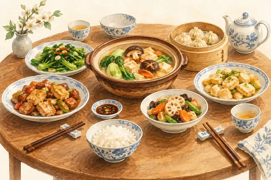 Cold-Water Fish Banquet 冷水鱼宴AI illustration · AI 示意图(仅供参考,非实拍)
Cold-Water Fish Banquet (冷水鱼宴) is a meal of many fish dishes served in Beitun (北屯), Fuhai County (福海县), Burqin County (布尔津县) and other towns of the Altay (阿勒泰) region in northern Xinjiang.
Read the dish guide →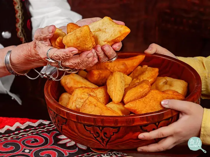 Kazakh Baursak Fried Dough 哈萨克包尔萨克
Kazakh Baursak Fried Dough (哈萨克包尔萨克) is the fried dough that Kazakh families in Altay Prefecture (阿勒泰地区) in Xinjiang serve with salty milk tea.
Read the dish guide →Photo adjustments
EXIF orientation normalized; resized without changing aspect ratio; converted to WebP. No subject edits.
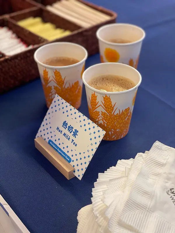 Salted Milk Tea 奶茶
Salted Milk Tea (奶茶) is brick tea mixed with boiled milk, hot water and salt. The Keketuohai Scenic Area Management Committee in Altay calls it the most important item of Kazakh food and drink, and in Ürümqi (乌鲁木齐) Xinjiang milk tea (新疆奶茶) is one of the common drinks.
Read the dish guide →
Photo adjustments
EXIF orientation normalized; resized without changing aspect ratio; converted to WebP. No subject edits.
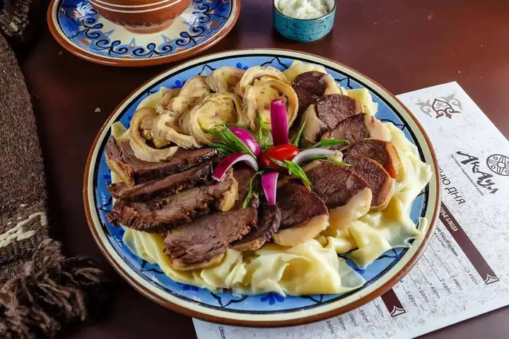 Smoked Horse Meat 熏马肉
Smoked Horse Meat (熏马肉) is a Kazakh cured meat of the Ili Kazakh Autonomous Prefecture (伊犁哈萨克自治州), Xinjiang.
Read the dish guide →Photo adjustments
EXIF orientation normalized; resized without changing aspect ratio; converted to WebP. No subject edits.
 Wind-Dried Meat 风干肉AI illustration · AI 示意图(仅供参考,非实拍)
Wind-Dried Meat (风干肉) is listed among the local specialties of Karamay, Xinjiang. It is grouped here with meat & poultry dishes; retain the complete Chinese name when comparing local menus.
Read the dish guide →All dish names · 全部菜名 (11)
More dishes from across Xinjiang are in the Xinjiang food guide.
Counties & districts in Altay Prefecture
7 areas belong directly to Altay Prefecture.
7 areas
Altay City 阿勒泰市
Altay (also spelled Altai or Aletai) is a county-level city in Altay Prefecture within Ili Kazakh Autonomous Prefecture, in far Northern Xinjiang, China. The city centre is located on the banks of Kelan River.
Explore the area →CountyBurqin County 布尔津县
Burqin County is a county in Xinjiang, China and is under the administration of the Kazakh autonomous area of Altay Prefecture. It has an area of 10,362 km² (4,001 sq mi) with a population of 70,000.
Explore the area →CountyFuyun County 富蕴县
Fuyun County, also known as Koktokay County (Uyghur: كۆكتوقاي ناھىيىسى; Kazakh: كوكتوعاي اۋدانى), is a county of Altay Prefecture, in the Xinjiang Uyghur Autonomous Region of China.
Explore the area →CountyFuhai County 福海县
Fuhai County as the official romanized name, also transliterated from Uyghur as Burultokay County (Uyghur: بۇرۇلتوقاي ناھىيىسى; Chinese: 布伦托海县), is a county in the Xinjiang Uyghur Autonomous Region and is…
Explore the area →Show fewer areas
Habahe County 哈巴河县
Habahe County as the official romanized name, also transliterated from Uyghur as Kaba County (Uyghur: قابا ناھىيىسى; Chinese: 哈巴县), is a county situated in the far north of the Xinjiang Uyghur Autonomous…
Explore the area →CountyQinggil County 青河县
Qinggil County (Uyghur), also Chinggil County, Qinghe County, is a county of Altay Prefecture in northeastern Xinjiang, China, bordering Bayan-Ölgii Province and Khovd Province in Mongolia to the east.
Explore the area →CountyJeminay County 吉木乃县
Jeminay County or Jimunai County, is a county situated in the north of the Xinjiang Uyghur Autonomous Region and is under the administration of the Altay Prefecture.
Explore the area →No areas match this name.
Plan your visit
Getting there
Search for 阿勒泰地区 in a map app to find stations and your accommodation.
Where to stay →Build your route
Kanas Lake and Hemu Village are about 40 km apart in a straight line. The linked place guides have entrance and visit details.
Continue with Xinjiang →More in Xinjiang
Sources & geographic information
Administrative names and parent areas: Official geographic directory · Reference date 2026-09-06.
Background text adapted from Altay Prefecture — Wikipedia contributors, under CC BY-SA 4.0. Text has been shortened and reorganized; source revision 1373538154.
Photo: Kanas Lake · Wang Xiaozhe and Meng Jie Taken in Jul. 2005 · CC BY-SA 3.0. Wikimedia thumbnail; fitted to the ranking-card frame.

Photo: Hemu Village · Nyx Ning · CC BY-SA 3.0. Wikimedia thumbnail; fitted to the ranking-card frame.

Photo: Koktokay · Yanxutong1215 · CC BY-SA 4.0. Full frame retained; proportionally resized and converted to WebP. No retouching or changes to the photographed subject. Card displays may crop the view.

Photo: Ulungur Lake · B_Aichner · B_Aichner — Ulungur_lake.jpg — CC BY-SA 4.0 · CC BY-SA 4.0. Full frame retained; proportionally resized and converted to WebP. No retouching or changes to the photographed subject. Card displays may crop the view.

Photo: Grassland Stone City · Source photographer · License not provided. EXIF orientation normalized; resized without changing aspect ratio; converted to WebP. No subject edits.
Photo: Baihaba Village · Source photographer · License not provided. EXIF orientation normalized; resized without changing aspect ratio; converted to WebP. No subject edits.
Photo: Birch Forest Scenic Area · Source photographer · License not provided. EXIF orientation normalized; resized without changing aspect ratio; converted to WebP. No subject edits.
Photo: Keketuohai No. 3 Mine Pit and Geology Exhibition · Source photographer · License not provided. EXIF orientation normalized; resized without changing aspect ratio; converted to WebP. No subject edits.
Photo: Five-Colour Beach · Nyx Ning · CC BY-SA 3.0. Full frame retained; proportionally resized and converted to WebP. No retouching or changes to the photographed subject. Card displays may crop the view.

Photo: Kanas Scenic Area · Newbamboo · CC BY-SA 4.0. Full frame retained; proportionally resized and converted to WebP. No retouching or changes to the photographed subject. Card displays may crop the view.

Photo: Hemu Village · Yanxutong1215 · CC BY-SA 4.0. Full frame retained; proportionally resized and converted to WebP. No retouching or changes to the photographed subject. Card displays may crop the view.

Photo: Altay-Hemu Highway Open Section · Source photographer · License not provided. EXIF orientation normalized; resized without changing aspect ratio; converted to WebP. No subject edits.
Photo: Jiangjunshan International Ski Resort · Source photographer · License not provided. EXIF orientation normalized; resized without changing aspect ratio; converted to WebP. No subject edits.
Map data © OpenStreetMap contributors. Pins mark approximate centres, not entrances or boundaries.