


Get to know Habahe County
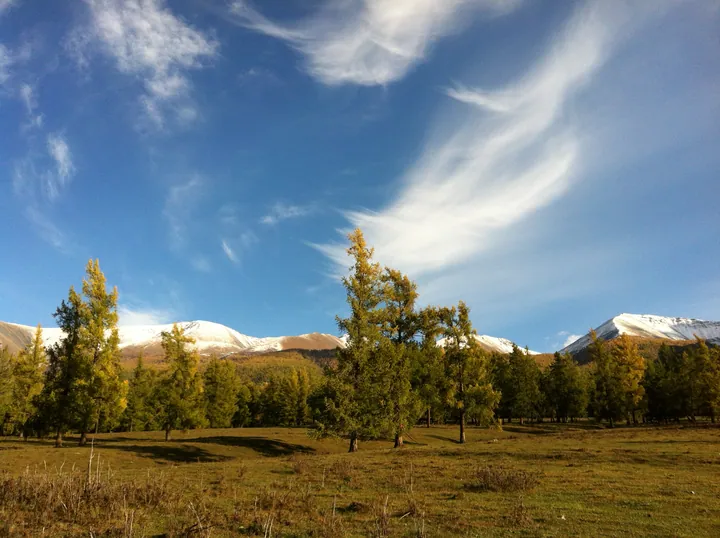
Photo adjustments
Full frame retained; proportionally resized and converted to WebP. No retouching or changes to the photographed subject. Card displays may crop the view.
- Administrative area
- County · 县
- Part of
- Altay Prefecture
- Chinese name
- 哈巴河县
- Local areas
- County guide
Area & population
- Area in the source
- 8,180.57 km²
- Population · 2020
- 82,524
- Administrative seat
- Aqchi
Source: cited geographic source, as of the dates shown.
Setting and landscape
Mountains above 1,200 m fill the north, rising to Shagangla (沙刚拉山) at 3,396 m; hills form a middle band, and the south is plain below 600 m. Four main rivers cross the county: the Irtysh (额尔齐斯河), the Haba, the Beliezi (别列孜河) and the Alakebieke (阿拉克别克河). The Haba, about 216 km long, is listed as the second-largest tributary of the Irtysh after the Burqin River. The county culture and tourism bureau describes Habahe as the county where the Irtysh, China's only river flowing to the Arctic Ocean, leaves the country. Springs are dry and windy, summers short and hot, autumns cool and winters cold.
History
In the early Qing the area was grazing land of the New Torghut Mongols (新土尔扈特). A Habahe tunju (屯局), an administrative office, was set up in 1903, a Habahe administrative bureau followed in 1912, and Habahe became a full county in 1930.
What to see
The county's three core scenic areas are known together as the 'three whites' (三白): Baihaba and Baishahu, both national 5A areas, and the 4A Birch Forest (白桦林). Baihaba (白哈巴), in Tierekti Township (铁热克提乡), keeps the look of an old Tuvan village of log cabins on the border; China Daily calls it 'China's westernmost village'. Kazakh villagers there have converted houses into homestays that serve late-evening sets of milk tea, hand-held mutton (手抓肉), air-dried meat (风干肉) and milk skin (奶皮子).
Baishahu (白沙湖) is a small lake ringed by sand dunes, about 800 m north to south and 500 m east to west, fed by seeping groundwater. Creeping juniper grows on the dunes, and a belt of silver poplar, poplar and birch stands close around the water, which holds reeds, sweet flag and wild lotus. In the northern mountains, the Narenxia summer pasture (那仁夏牧场) lies in a mountain basin at 1,390 m on the Naren River (那仁河), backed by spruce, fir and pine taiga. In Saerbulake (萨尔布拉克) the Duogate rock art (多尕特岩画) comprises close to a thousand stone carvings and paintings scattered between Yushiaxia (玉什阿夏村) and Halonggou (哈龙沟村) villages.
Food and local products
The county culture and tourism bureau promotes sea-buckthorn banquets (沙棘宴) and dubaoji (肚包鸡) as its specialty dishes.
Highlights
- Baihaba Village 白哈巴: National 5A scenic area: a Tuvan log-cabin village on the border in Tierekti Township.
- Baishahu 白沙湖: National 5A scenic area: a groundwater-fed lake ringed by dunes and poplar and birch.
- Birch Forest Scenic Area 白桦林景区: National 4A scenic area, one of the county's three 'white' sights.
- Narenxia Summer Pasture 那仁夏牧场: Mountain-basin pasture at 1,390 m on the Naren River.
- Duogate Rock Art 多尕特岩画: Close to a thousand stone carvings and paintings in Saerbulake.
Sources for this guide
旅游资源_哈巴河县人民政府 · Habahe County People's Government
哈巴河县“去‘辽·愈’地”文旅推介会乌鲁木齐举办-中新网·新疆 · China News Service (Xinjiang)
新疆哈巴河:白哈巴“夜经济”让边境游从“过路”变“过夜” - 中国日报网 · China Daily (chinadaily.com.cn)
哈巴河县 - 维基百科,自由的百科全书 · Chinese Wikipedia · CC BY-SA 4.0
Original English written from the listed sources and checked sentence by sentence against quoted extracts by a separate reviewer. Updated 2026-09-25.
Explore Habahe County
Core places to explore, with English and Chinese names.
Places to explore around Habahe County
 Baihaba Village · 白哈巴村
Baihaba Village白哈巴村
Baihaba village (白哈巴村) is a village on China's border with Kazakhstan in Habahe County, Altay Prefecture, Xinjiang.
Read the place guide → AI illustration · AI 示意图(仅供参考,非该地点实拍)
Baisha Lake白沙湖
Baisha Lake (白沙湖) is a small desert lake ringed by sand dunes in Habahe County, Altay Prefecture, Xinjiang, and the core of the 10th Division's 185th Regiment scenic area.
Read the place guide →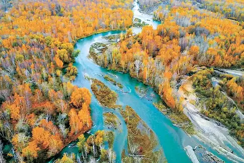 Birch Forest Scenic Area · 白桦林景区
Birch Forest Scenic Area白桦林景区
The Birch Forest Scenic Area (白桦林景区) is a naturally grown birch belt beside the Haba River, four kilometres from the Habahe county seat in Altay Prefecture, Xinjiang.
Read the place guide →Plan your visit
Getting there
Habahe County is about 130 km in a straight line from central Altay Prefecture. Search for 哈巴河县 in a map app to find stations and your accommodation.
Where to stay →Build your route
Baihaba Village and Baisha Lake are both listed here. The linked place guides have entrance and visit details.
Continue with Altay Prefecture →More in Altay Prefecture
Sources & geographic information
Administrative names and parent areas: Official geographic directory · Reference date 2026-09-06.
Some facts checked against 哈巴河县 — Wikipedia contributors, CC BY-SA 4.0.
Photo: Baihaba Village · Source photographer · License not provided. EXIF orientation normalized; resized without changing aspect ratio; converted to WebP. No subject edits.
Photo: Birch Forest Scenic Area · Source photographer · License not provided. EXIF orientation normalized; resized without changing aspect ratio; converted to WebP. No subject edits.
Map data © OpenStreetMap contributors. Pins mark approximate centres, not entrances or boundaries.