


Get to know Zhaosu County

Photo adjustments
Full frame retained; proportionally resized and converted to WebP. No retouching or changes to the photographed subject. Card displays may crop the view.
- Administrative area
- County · 县
- Part of
- Ili Kazakh Autonomous Prefecture
- Chinese name
- 昭苏县
- Local areas
- County guide
Area & population
- Area in the source
- 10,426.93 km²
- Population · 2020
- 146,887
- Administrative seat
- Mongolküre Town
Source: cited geographic source, as of the dates shown.
Setting and landscape
The main ridge of the Tianshan closes the basin to the south and blocks hot, dry winds from the southern Xinjiang deserts; the lower Wusun Mountains (乌孙山) lie to the north and the Chadanr Mountains (查旦尔山) to the west. Khan Tengri (汗腾格里峰) in the south-west feeds the Tekes, the largest tributary of the Ili. Chinese Wikipedia notes that Zhaosu is the only county in Xinjiang without desert. The county government gives an average temperature of 4.0°C, describes long winters with "no real summer", and calls Zhaosu a well-known summer retreat.
History
The county government calls Zhaosu the old homeland of the Wusun (乌孙). The Chinese name joins two parts of the old place name Liusumen Lamazhao (六苏门喇嘛昭): "six sumu", or banner companies, and the lama temple, meaning Shengyou Temple (圣佑庙). A Zhaosu administrative bureau was set up in 1938 and the county in 1942. The Kazakh name, Mongolküre, means "place of the Mongol temple".
What to see
The Xiata ancient trail (夏塔古道) runs 120 kilometres across the Tianshan and has long been called a "ladder to heaven" linking the north and south of the range; the county government says the monk Xuanzang (玄奘) passed this way, and the trail area was approved as a national forest park in 2010. The Xiaohongnahai stone figure (小洪纳海石人), the Xiata ancient city (夏塔古城), the Gedeng Mountain victory stele (格登山记功碑) and Shengyou Temple are national protected sites. In midsummer the county's rapeseed fields flower across a million mu; the county government calls Zhaosu the largest spring rapeseed area in Xinjiang, with more than 70 per cent of the region's planting.
Food and local products
This is horse country: the county is known as the "home of the heavenly horse" (中国天马之乡), breeds ceremonial horses and keeps more than 100,000 of them. It is also where the Ili horse, Xinjiang brown cattle and fine-wool sheep were first bred, and it is named China's "home of brown cattle".
Highlights
- Xiata ancient trail 夏塔古道: 120 km route across the Tianshan, approved as a national forest park in 2010.
- Shengyou Temple 圣佑庙: The lama temple behind the county's name; a national protected site.
- Gedeng Mountain victory stele 格登山记功碑: National protected site.
- Xiaohongnahai stone figure 小洪纳海石人: National protected site.
- Rapeseed fields 油菜花: A million mu of spring rapeseed flowering in midsummer.
Sources for this guide
昭苏县概况 - 县情介绍 - 昭苏县人民政府网 · Zhaosu County People's Government
昭苏县 - 维基百科,自由的百科全书 · Chinese Wikipedia · CC BY-SA 4.0
Original English written from the listed sources and checked sentence by sentence against quoted extracts by a separate reviewer. Updated 2026-09-25.
Explore Zhaosu County
Core places to explore, with English and Chinese names.
Places to explore around Zhaosu County
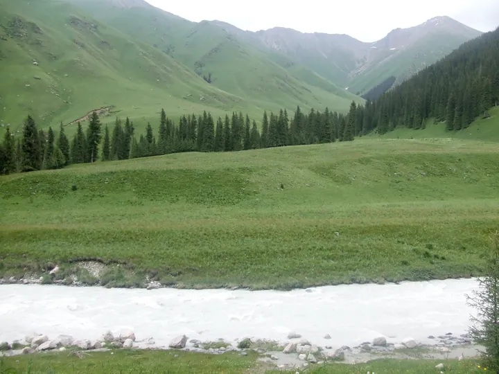 The 夏塔 gorge: a milky grey glacial river in the foreground with boulders along its bank, a broad green meadow rising behind it, a band of dark spruce on the slope, and snow-patched rocky peaks closing the head of the valley under an overcast sky.
Xiata Scenic Area夏塔
Xiate (夏塔) is a 4A-level scenic area in Zhaosu County (昭苏县), Ili Kazakh Autonomous Prefecture, Xinjiang. The county government describes its landscape as a vertical mountain sequence of snow mountains, meadow, forest and river formed by glaciation, and records that the scenic area contains the Xiate ancient road.
Read the place guide → Horses wading in a river on Zhaosu grassland, with a rider and distant mountains · 昭苏草原上,马群涉水,远处群山连绵 Source-recorded photograph date: 2025-10-18 13:32:29.
Zhaosu Grassland昭苏草原
The Zhaosu grassland (昭苏草原) is the grassland of Zhaosu County (昭苏县) in the south-west of Ili Kazakh Autonomous Prefecture, Xinjiang, a high intermontane basin ringed by mountains at an average elevation of 2,018 m. The county government records 7.36 million mu of natural pasture in the county, and the Ministry of Agriculture and Rural Affairs lists the Zhaosu grassland horse-herding system among China's important agricultural heritage.
Read the place guide →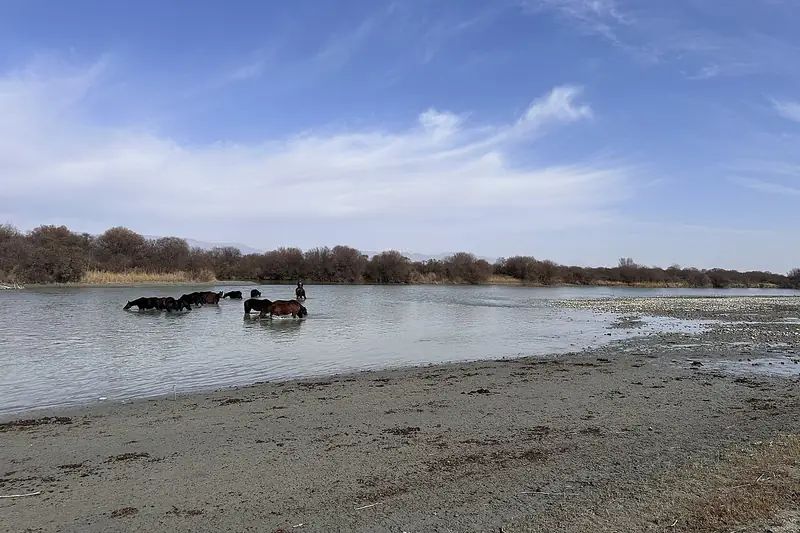 Zhaosu Wetland Park (昭苏湿地公园), Zhaosu County. Photograph: "新疆昭苏草原马牧养系统封面".
Zhaosu Wetland Park昭苏湿地公园
Zhaosu Wetland Park (昭苏湿地公园) is a wetland park on the north bank of the river in Zhaosu County (昭苏县), Ili Kazakh Autonomous Prefecture, Xinjiang. The county government records that it covers 1.04 million mu, a third of the wetland area of the whole prefecture, and that it is laid out in nine named zones.
Read the place guide →Plan your visit
Getting there
Zhaosu County is about 85 km in a straight line from central Ili Kazakh Autonomous Prefecture. Search for 昭苏县 in a map app to find stations and your accommodation.
Where to stay →Build your route
Xiata Scenic Area and Zhaosu Grassland are both listed here. The linked place guides have entrance and visit details.
Continue with Ili Kazakh Autonomous Prefecture →More in Ili Kazakh Autonomous Prefecture
Sources & geographic information
Administrative names and parent areas: Official geographic directory · Reference date 2026-09-06.
Some facts checked against 昭苏县 — Wikipedia contributors, CC BY-SA 4.0.
Photo: Xiata Scenic Area · Nyx Ning · CC BY-SA 3.0. Full frame retained; proportionally resized and converted to WebP. No retouching or changes to the photographed subject. Card displays may crop the view.

Photo: Zhaosu Grassland · HaziiDozen · CC BY-SA 4.0. Full frame retained; proportionally resized and converted to WebP. No retouching or changes to the photographed subject. Card displays may crop the view.

Photo: Zhaosu Wetland Park · HaziiDozen · CC BY-SA 4.0. Full frame retained; EXIF orientation normalized, proportionally resized to at most 800 pixels and converted to WebP. No generated pixels or subject changes. Cards may crop the display.

Map data © OpenStreetMap contributors. Pins mark approximate centres, not entrances or boundaries.