


Get to know Baoshan
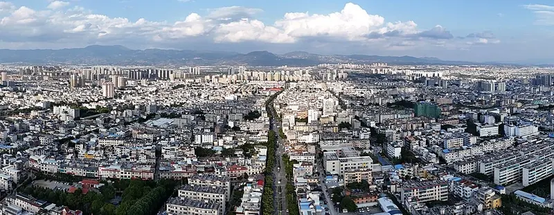
Photo adjustments
Full frame retained; proportionally resized and converted to WebP. No retouching or changes to the photographed subject. Card displays may crop the view.
- Administrative area
- Prefecture-level city · 地级市
- Part of
- Yunnan
- Chinese name
- 保山市
- Local areas
- 5 local areas
Area & population
- Area in the source
- 19,064.60 km²
- Population · 2010
- 2,506,491
Source: cited geographic source, as of the dates shown.
Transport
Baoshan lies on the main road from Ruili on the Burmese border to Kunming. The Baoshan−Kunming section is completed highway, and the Baoshan-Ruili part was completed in 2016, finalizing the highway net crossing Yunnan east-to-west. It is the first finished highway between China and Myanmar.
Explore Baoshan
Core places to explore, with English and Chinese names.
Heshun Town 和顺古镇
Tengchong 腾冲
Tengchong Volcano and Rehai Geothermal Area 腾冲火山热海旅游区
Jifei Hot Spring 鸡飞温泉
Beihai Wetland 北海湿地
Guoshang Cemetery and West Yunnan War Memorial Hall 国殇墓园与滇西抗战纪念馆
Tengchong Volcano Geopark 腾冲火山地质公园
Tengchong Rehai Geothermal Area 腾冲热海
Jiangdong Ginkgo Village 银杏村
Gaoligong Mountains Baihualing Nature Trail 高黎贡山百花岭正规自然观察线路
Baoshan Museum 保山博物馆
Qinghuahai Wetland 青华海湿地
Songshan Battlefield Site 松山战役遗址
Longling War of Resistance Memorial Hall 龙陵抗战纪念馆
Longyang District 隆阳区
Shidian County 施甸县
Longling County 龙陵县
Changning County 昌宁县
Tengchong 腾冲市
Places to explore around Baoshan
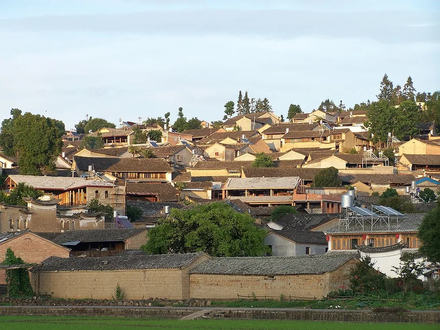 Traditional tiled roofs on the hillside of Heshun near Tengchong, June 2011.
Heshun Town和顺古镇
Heshun rises above wetland and cultivated land outside Tengchong. Its lanes connect hillside courtyard houses with family and community buildings, while laundry pavilions along the water reveal an everyday use of the town’s…
Read the place guide →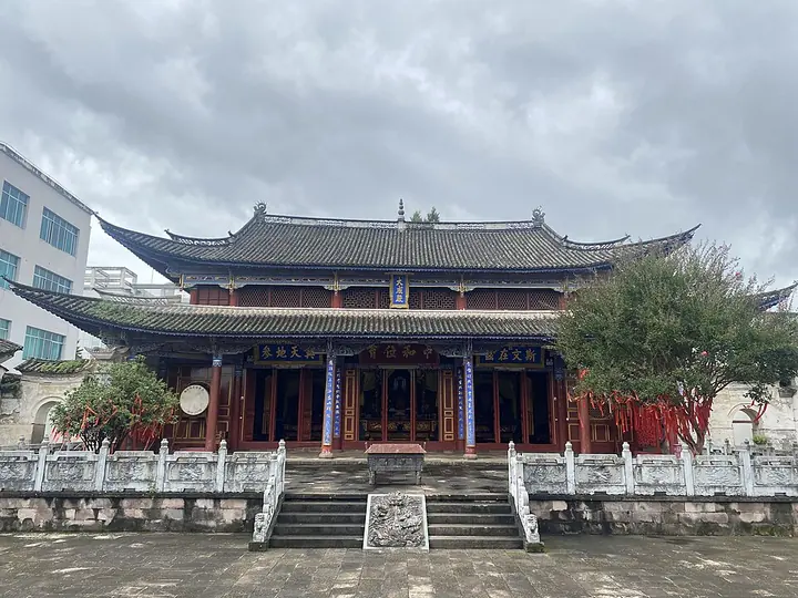 Dacheng Hall at Tengchong Confucian Temple, Tengchong · 腾冲文庙大成殿 Photograph date recorded by the source: 3 August 2023, 13:01:38.
Tengchong腾冲
Tengchong combines a compact urban sightseeing area with volcanic landscapes farther outside town. Dieshui River Waterfall brings a dramatic water feature close to the centre, while the National Martyrs Cemetery and Western…
Read the place guide →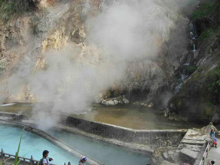 Steaming hot spring pools and a cascading stream at the Rehai geothermal area, Tengchong · 腾冲热海地热区温泉水潭及跌水 Source-recorded photograph date: 2013-08-04 10:51:18.
Tengchong Volcano and Rehai Geothermal Area腾冲火山热海旅游区
Tengchong's Volcano and Rehai tourism area combines volcanic landforms with a separate geothermal landscape.
Read the place guide →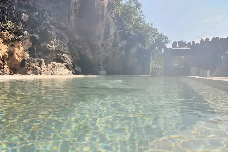 Jifei Hot Spring · 鸡飞温泉
Jifei Hot Spring鸡飞温泉
Jifei hot spring is a geothermal site in southwestern Changning County, Baoshan, first established in the late Ming to early Qing transition and listed as a county-level scenic area in 1982, described locally as one of the 'Eight Sights of West Yunnan'.
Read the place guide → AI illustration · AI 示意图(仅供参考,非该地点实拍)
Beihai Wetland北海湿地
Beihai Wetland is a nature reserve in Tengchong, Baoshan, centred on the Beihai volcanic dammed lake and the Qinghai crater lake, one of 33 nationally key-protected wetlands in China and, according to Tengchong's own government, the only volcanic dammed lake in southwest China and Yunnan's only nationally protected wetland.
Read the place guide → AI illustration · AI 示意图(仅供参考,非该地点实拍)
Guoshang Cemetery and West Yunnan War Memorial Hall国殇墓园与滇西抗战纪念馆
Guoshang Cemetery and the adjoining War of Resistance Museum in West Yunnan stand together one kilometre southwest of Tengchong city, Baoshan, commemorating the Chinese Expeditionary Force soldiers who died retaking Tengchong from Japanese occupation in 1944. The cemetery was built in 1944-1945 at the advocacy of Li Genyuan; the museum, a separate building completed in 2013, stands on its east side.
Read the place guide →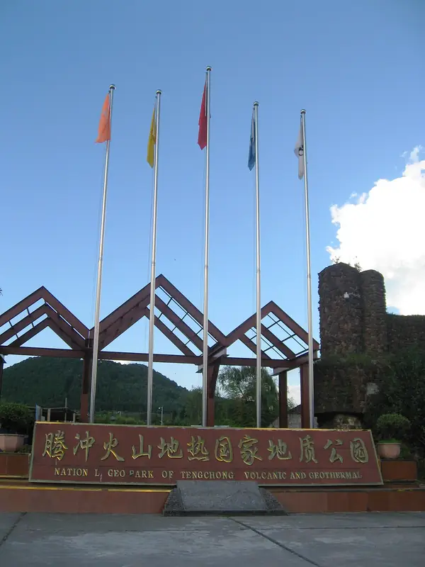 Tengchong Volcano Geopark · 腾冲火山地质公园
Tengchong Volcano Geopark腾冲火山地质公园
Tengchong's volcano scenic area, in Tengchong, Baoshan, is a field of Cenozoic dormant volcanoes covering 221.36 square kilometres, one of mainland China's four major volcanic groups, holding, according to the Baoshan tourism authority, 97 volcanoes of which 25 cones have well-preserved craters. The Ming-dynasty geographer Xu Xiake surveyed the volcanoes in 1639 and recorded them in his 'Travels of Xu Xiake'.
Read the place guide →Steaming hot-spring pools and terraces at Rehai (Tengchong Hot Sea), Tengchong, Baoshan · 保山市腾冲市腾冲热海景区蒸腾的温泉水池 Source-recorded photograph date: 2013-08-04 10:51:18.Tengchong Rehai Geothermal Area腾冲热海
Rehai (Hot Sea) is a geothermal scenic area about eight kilometres southwest of Tengchong city, Baoshan, roughly 1,520 metres above sea level and covering about 9 square kilometres, known in the Ming and Qing dynasties as 'a pool of hot sea', one of old Tengyue's twelve historic sights. The Ming-dynasty geographer Xu Xiake surveyed it in 1639 and described its geothermal landscape in detail.
Read the place guide → AI illustration · AI 示意图(仅供参考,非该地点实拍)
Jiangdong Ginkgo Village银杏村
Jiangdong Ginkgo Village is a scenic area 37 kilometres north of Tengchong city, Baoshan, adjacent to the national volcano geopark, comprising the four natural villages of Chenjiazhai, Baxin, Jiangyun and Sihe with a combined population of 4,012. It has a thousand-year farming history and is known for a natural contiguous ginkgo forest of over 10,000 mu with more than 30,000 trees, over 1,200 of them more than a century old.
Read the place guide →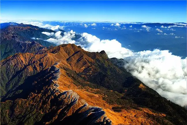 Gaoligong Mountains Baihualing Nature Trail · 高黎贡山百花岭正规自然观察线路
Gaoligong Mountains Baihualing Nature Trail高黎贡山百花岭正规自然观察线路
This route runs through Baihualing, a natural village of mixed Han, Lisu, Bai and other residents in Mangkuan township, Longyang district, Baoshan, on the eastern slope of the southern end of Gaoligong Mountain at about 1,400 metres elevation. The Baihualing area has 474 recorded bird species, 63.5 per cent of all bird species recorded across the Gaoligong Mountain region, and the Department of Natural Resources case study says it is acclaimed as 'China's five-star birdwatching sanctuary' and 'China's golden triangle of birdwatching'.
Read the place guide →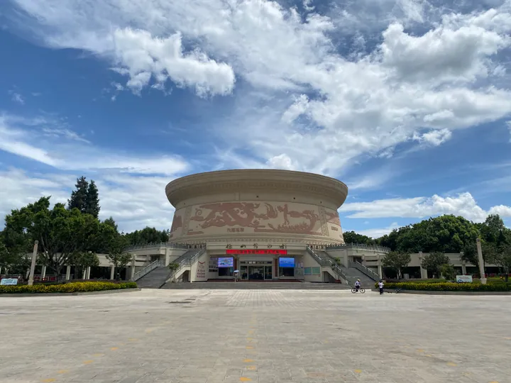 Exterior of Baoshan Museum, Longyang District · 保山博物馆外观,隆阳区 Source-recorded photograph date: 2023-07-25 15:13:06.
Baoshan Museum保山博物馆
Baoshan's city museum in a bronze-drum-shaped building, with galleries on the Ailao kingdom, Yongchang history and the war years.
Read the place guide →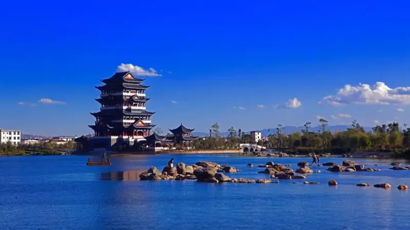 Qinghuahai Wetland · 青华海湿地
Qinghuahai Wetland青华海湿地
Qinghua Hai National Wetland Park lies in the eastern urban district of Longyang district, Baoshan, covering 1,363 hectares of lake, reservoir ponds, river, marsh and forest habitat. A causeway running north to south divides the water into West Lake and East Lake; the name Qinghua was given by the Ming-dynasty scholar Yang Shen, exiled to Yongchang, who was captivated by the lake's beauty.
Read the place guide → Songshan Battlefield Site (松山战役遗址), Longling County. Photograph: "Songshan Battle Site 01".
Songshan Battlefield Site松山战役遗址
Mountain battlefield above the Nu River in Longling, where Chinese forces took a fortified Japanese position after a siege ending 7 September 1944.
Read the place guide →AI illustration · AI 示意图(仅供参考,非该地点实拍)Longling War of Resistance Memorial Hall龙陵抗战纪念馆
The Longling War of Resistance Museum stands in Longling County, Baoshan, its two-storey main building surrounded by a large relief wall, a bunker of the invading Japanese army, war sculptures and memorial features across a site of 5,190.98 square metres. It documents the Longling and Songshan campaigns of 1944: the Chinese Expeditionary Force forced a crossing of the Nujiang River on 4 June and, after three months and three days of fighting, annihilated the Japanese garrison at Songshan, in Longling county, by 7 September, at a cost Yunnan Daily gives as 7,000 Expeditionary Force dead, reopening the Yunnan-Burma corridor.
Read the place guide →Local life & food
Baoshan local specialties
保山市特色美食 · 11 specialties to discover
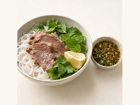 Dai-style lemon sa with rice noodles 傣味柠檬撒AI dish illustration / AI 菜品示意图
Expect a sharp citrus taste, fresh herbs and chilli, with soft noodles carrying the dressing. The mixture can be intense, so a little dip may season more noodles than its small bowl suggests.
Source ↗Read the dish guide →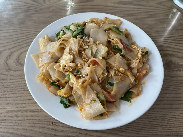 Tengchong Dajiujia 腾冲大救驾
The dish is soft and chewy, with browned contact points and a savory, lightly tangy mix from the vegetables. Chili level varies by kitchen.
Source ↗Read the dish guide →
Photo adjustments
EXIF orientation applied where present; resized proportionally to at most 640 px on the long edge and encoded as WebP. No crop, retouching, recoloring or subject changes.
 Tengchong Rice Cake Noodles 腾冲饵丝
Tengchong Rice Cake Noodles (腾冲饵丝) begin with rice that is washed, soaked, steamed, pressed, cut and dried.
Read the dish guide →
Photo adjustments
Full frame retained; proportionally resized and converted to WebP. No retouching or changes to the photographed subject. Card displays may crop the view.
 Tengchong xidoufen breakfast 腾冲稀豆粉AI dish illustration · AI 菜品示意图
The pea base is softly earthy and creamy without necessarily containing dairy. Crisp fried dough offers a strong contrast to the spoonable texture.
Source ↗Read the dish guide →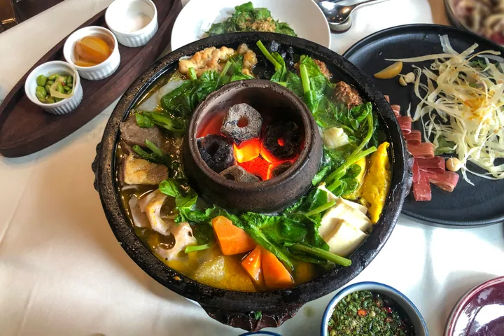 Earthenware Hot Pot 土锅子
Earthenware Hot Pot (土锅子) is a layered meat-and-vegetable pot associated with Tengchong (腾冲), within Baoshan (保山), Yunnan.
Read the dish guide →.jpg)
Photo adjustments
Full frame retained; proportionally resized and converted to WebP. No retouching or changes to the photographed subject. Card displays may crop the view.
 Baoshan Fire Ladle Beef 保山火瓢牛肉
Baoshan Fire Ladle Beef (保山火瓢牛肉) is a beef hotpot from Baoshan (保山) in western Yunnan, cooked in a copper ladle (铜瓢) that serves as the pot.
Read the dish guide →Photo adjustments
EXIF orientation normalized; resized without changing aspect ratio; converted to WebP. No subject edits.
 Shidian Bean Sheets 施甸豆片
Shidian Bean Sheets (施甸豆片) is listed among the local specialties of Baoshan, Yunnan. It is grouped here with regional dishes & banquets; retain the complete Chinese name when comparing local menus.
Read the dish guide →Photo adjustments
EXIF orientation normalized; resized without changing aspect ratio; converted to WebP. No subject edits.
 Longling Yellow Goat Hot Pot 龙陵黄山羊火锅Reference photo of a similar dish · 同类菜品参考照片
Longling Yellow Goat Hot Pot (龙陵黄山羊火锅) is listed among the local specialties of Baoshan, Yunnan. The name includes 羊 (sheep).
Read the dish guide →
All dish names · 全部菜名 (11)
- Dai-style lemon sa with rice noodles · 傣味柠檬撒
- Tengchong Dajiujia · 腾冲大救驾
- Tengchong Rice Cake Noodles · 腾冲饵丝
- Tengchong xidoufen breakfast · 腾冲稀豆粉
- Earthenware Hot Pot · 土锅子
- Baoshan Fire Ladle Beef · 保山火瓢牛肉
- Shidian Bean Sheets · 施甸豆片
- Longling Yellow Goat Hot Pot · 龙陵黄山羊火锅
- Changning Black Tea Stewed Chicken · 昌宁红茶炖鸡
- Yongchang Pressed Salted Duck · 永昌板鸭
- Tengchong Clay Jar Chicken · 腾冲坛子鸡
More dishes from across Yunnan are in the Yunnan food guide.
Counties & districts in Baoshan
5 areas belong directly to Baoshan.
5 areas
Longyang District 隆阳区
Longyang District (simplified Chinese: 隆阳区; traditional Chinese: 隆陽區; pinyin: Lóngyáng Qū) is a district of the city of Baoshan, Yunnan province, China.
Explore the area →CountyShidian County 施甸县
Shidian County is under the administration of the prefecture-level city of Baoshan, in the west of Yunnan province, China. Its seat is the town of Dianyang (甸阳镇).
Explore the area →CountyLongling County 龙陵县
Longling County (simplified Chinese: 龙陵县; traditional Chinese: 龍陵縣; pinyin: Lónglíng Xiàn) is a county in Baoshan City, in the west of Yunnan Province, China, bordering Burma's Shan State to the south.
Explore the area →CountyChangning County 昌宁县
Changning County (simplified Chinese: 昌宁县; traditional Chinese: 昌寧縣; pinyin: Chāngníng Xiàn; lit. 'good peace', Burmese: ကောင်းငြိမ်း) is a county located in Baoshan Prefecture, Yunnan Province, China.
Explore the area →No areas match this name.
Plan your visit
Getting there
Search for 保山市 in a map app to find stations and your accommodation.
Where to stay →Build your route
Heshun Town and Tengchong are about 3 km apart in a straight line. The linked place guides have entrance and visit details.
Continue with Yunnan →More in Yunnan
Sources & geographic information
Administrative names and parent areas: Official geographic directory · Reference date 2026-09-06.
Background text adapted from Baoshan, Yunnan — Wikipedia contributors, under CC BY-SA 4.0. Text has been shortened and reorganized; source revision 1346409438.
Photo: Heshun Town · oldhouse.yin · CC BY-SA 3.0. Proportionally resized and converted to WebP without cropping, retouching or changing the photographed subject.

Photo: Tengchong · 瑞丽江的河水 · 瑞丽江的河水 — 腾冲文庙_-_大成殿_-_2023-08-03_02.jpg — CC BY-SA 4.0 · CC BY-SA 4.0. Full frame retained; proportionally resized and converted to WebP. No retouching or changes to the photographed subject. Card displays may crop the view.

Photo: Tengchong Volcano and Rehai Geothermal Area · Kcx36 · CC BY-SA 4.0. Full frame retained; proportionally resized and converted to WebP. No retouching or changes to the photographed subject. Card displays may crop the view.

Photo: Jifei Hot Spring · Source photographer · License not provided. EXIF orientation normalized; resized without changing aspect ratio; converted to WebP. No subject edits.
Photo: Tengchong Volcano Geopark · Kcx36 · CC BY-SA 4.0. EXIF orientation normalized; resized without changing aspect ratio; converted to WebP. No subject edits.

Photo: Tengchong Rehai Geothermal Area · Kcx36 · CC BY-SA 4.0. Full frame retained; proportionally resized and converted to WebP. No retouching or changes to the photographed subject. Card displays may crop the view.
Photo: Gaoligong Mountains Baihualing Nature Trail · Source photographer · License not provided. EXIF orientation normalized; resized without changing aspect ratio; converted to WebP. No subject edits.
Photo: Baoshan Museum · 瑞丽江的河水 · CC BY-SA 4.0. Full frame retained; proportionally resized and converted to WebP. No retouching or changes to the photographed subject. Card displays may crop the view.

Photo: Qinghuahai Wetland · Source photographer · License not provided. EXIF orientation normalized; resized without changing aspect ratio; converted to WebP. No subject edits.
Photo: Songshan Battlefield Site · STW932 · CC BY-SA 4.0. Full frame retained; EXIF orientation normalized, proportionally resized to at most 800 pixels and converted to WebP. No generated pixels or subject changes. Cards may crop the display.

Map data © OpenStreetMap contributors. Pins mark approximate centres, not entrances or boundaries.