


Get to know Lantian County

Photo adjustments
Full frame retained; proportionally resized and converted to WebP. No retouching or changes to the photographed subject. Card displays may crop the view.
- Administrative area
- County · 县
- Part of
- Xi’an
- Chinese name
- 蓝田县
- Local areas
- County guide
Area & population
- Area in the source
- 2,005.95 km²
- Population · 2019
- 536,100
Source: cited geographic source, as of the dates shown.
Setting and landscape
The land tilts from southeast to northwest, between the Qinling to the south and Mount Li (骊山) to the north. The higher southeast belongs to the Qinling spurs, while the centre and west alternate between river flats and tablelands (原). The highest point reaches 2,449 metres; the county town stands at 469 metres.
What to see
The Lantian Man Site (蓝田猿人遗址) on Gongwangling (公王岭) in Jiujianfang (九间房镇) is where a human skull dated to 1.15 million years ago was found; the latest dating puts it at 1.63 million. The site opened to visitors in 1982, the year it became a national protected site, and it is a core area of the Qinling Zhongnanshan UNESCO Global Geopark.
Shuilu Temple (水陆庵), 10 kilometres east of the county town in Puhua (普化镇), stands on an island in the Lan River (蓝水). It began as the Water-and-Land Hall of Wuzhen Temple (悟真寺) in the Sui dynasty, and its clay wall sculptures were remade between 1563 and 1567. More than 3,700 clay wall figures survive, mixing scenes from the Buddha's life and the 500 arhats crossing the sea with Confucian and Taoist themes; the county points out a bearded, male Guanyin among them. It is a national protected site.
Wangshun Mountain National Forest Park (王顺山国家森林公园) at Lanqiao (蓝桥镇) is known for its granite peaks, pines, odd-shaped rocks, azaleas and cliff inscriptions; its summit, Yuhuangding (玉皇顶), rises to 2,239 metres. Bailuyuan Film City (白鹿原影视城), opened in 2016, is built around White Deer Plain (白鹿原), the prize-winning novel by Chen Zhongshi (陈忠实), and its screen adaptation. The county also keeps the tomb of the writer Cai Wenji (蔡文姬) and the Wangchuan (辋川) estate once lived in by the Tang poet and painter Wang Wei (王维).
Food and local products
Lantian jade (蓝田玉), mined at Wangchuan, is one of China's four famous jades and has been a protected geographical indication since 2004; tradition says the First Emperor's seal was cut from it. The county's culture, tourism and sports bureau lists ten well-known local snacks, among them buckwheat-and-wheat hele noodles (荞面饸饹), thin and yellow; hollow hand-pulled noodles from Louzhu village (楼祝村); spring-onion flatbread; crystal cakes scented with rose and candied orange; and dried tofu from Bayuan (灞源).
Highlights
- Lantian Man Site 蓝田猿人遗址: Find-spot of a human skull dated to 1.15 million years ago (latest dating 1.63 million); national protected site since 1982.
- Shuilu Temple 水陆庵: More than 3,700 clay wall sculptures, remade in 1563–1567, on a river island.
- Wangshun Mountain 王顺山: Granite peaks rising to 2,239 metres at Yuhuangding; a national forest park.
- Lantian jade 蓝田玉: One of China's four famous jades, mined at Wangchuan; geographical indication since 2004.
- Lantian buckwheat noodles 蓝田荞面饸饹: Thin, yellow buckwheat-and-wheat hele noodles, one of the county's ten listed snacks.
Sources for this guide
历史文化-蓝田县人民政府 · Lantian County People's Government
地貌-蓝田县人民政府 · Lantian County People's Government
蓝田县十大名小吃-蓝田县人民政府 · Lantian County Culture, Tourism and Sports Bureau
蓝田玉-蓝田县人民政府 · Lantian County Culture, Tourism and Sports Bureau
旅游概览-蓝田县人民政府 · Lantian County Culture, Tourism and Sports Bureau
水陆庵-蓝田县人民政府 · Lantian County Culture, Tourism and Sports Bureau
蓝田猿人遗址-蓝田县人民政府 · Lantian County Culture, Tourism and Sports Bureau
王顺山国家森林公园-蓝田县人民政府 · Lantian County Culture, Tourism and Sports Bureau
白鹿原影视城-蓝田县人民政府 · Lantian County Culture, Tourism and Sports Bureau
Original English written from the listed sources and checked sentence by sentence against quoted extracts by a separate reviewer. Updated 2026-09-25.
Explore Lantian County
Core places to explore, with English and Chinese names.
Places to explore around Lantian County
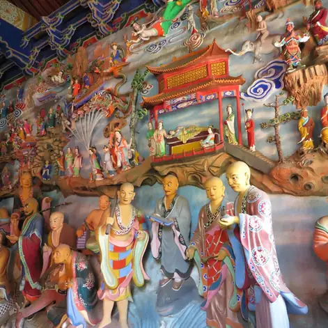 Shuilu Temple · 水陆庵
Shuilu Temple水陆庵
Shuilu Temple in Lantian preserves an extraordinary interior of colored clay sculpture within a compact east-facing courtyard. Its main hall contains thousands of figures arranged across walls and partitions: large Buddhas are…
Read the place guide →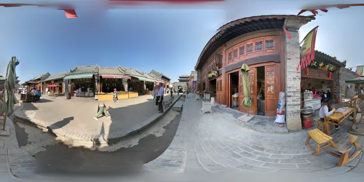 Recreated old-town streetscape at Bailuyuan Film City, Lantian County, Xi'an · 西安市蓝田县白鹿原影视城复古街景 Source-recorded photograph date: 2017-04-01.
Bailuyuan Film City白鹿原影视城
Bailuyuan Film City uses the setting and characters of Chen Zhongshi’s White Deer Plain to interpret Guanzhong village life through film sets. Bailu Village includes the homes of Bai Jiaxuan and Lu Zilin, a clan ancestral hall…
Read the place guide →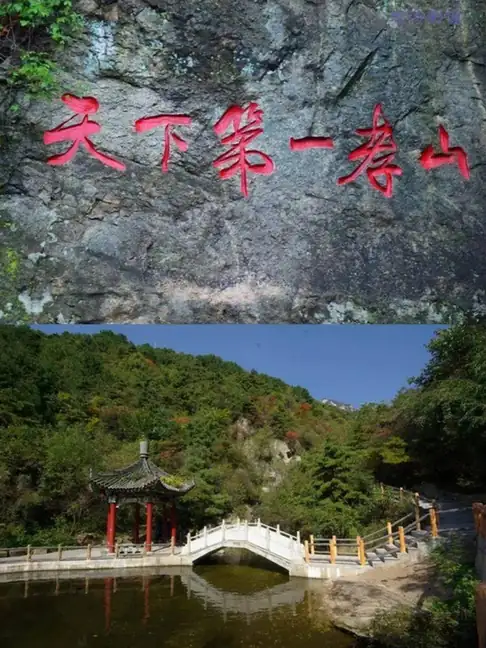 Wangshun Mountain · 王顺山
Wangshun Mountain王顺山
Wangshun Mountain National Forest Park (王顺山国家森林公园) lies within Lanqiao Town, southeast of the county seat of Lantian County in Xi'an, Shaanxi. It takes in 3,633 hectares of landscape forest, and its main summit, Yuhuangding, stands at 2,239 metres.
Read the place guide →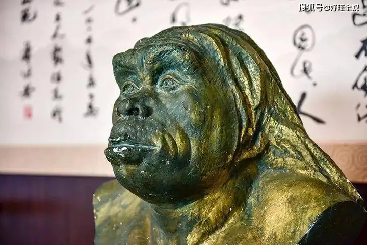 Lantian Man Site · 蓝田猿人遗址
Lantian Man Site蓝田猿人遗址
The Lantian Man site (蓝田猿人遗址) stands on Gongwangling in Jiujianfang Town, Lantian County, Xi'an, Shaanxi, and is known for the Homo erectus skullcap excavated there. It is a State Council listed relic, a national AAA tourist scenic area and a core scenic area of the Qinling Zhongnanshan Global Geopark.
Read the place guide →Local life & food
Lantian County local specialties
蓝田县特色美食 · 1 specialties to discover
 Lantian buckwheat noodles 蓝田荞面饸饹AI illustration · AI 示意图
They have a close, earthy bite and less elasticity than all-wheat noodles. Garlic, vinegar and chili can make the cold version particularly lively.
Source ↗Read the dish guide →All dish names · 全部菜名 (1)
More dishes from across Shaanxi are in the Shaanxi food guide.
Plan your visit
Getting there
Lantian County is about 35 km in a straight line from central Xi’an. Search for 蓝田县 in a map app to find stations and your accommodation.
Where to stay →Build your route
Shuilu Temple and Bailuyuan Film City are about 15 km apart in a straight line. The linked place guides have entrance and visit details.
Continue with Xi’an →More in Xi’an
Sources & geographic information
Administrative names and parent areas: Official geographic directory · Reference date 2026-09-06.
Photo: Shuilu Temple · Source photographer · License not provided. EXIF orientation normalized; resized without changing aspect ratio; converted to WebP. No subject edits.
Photo: Bailuyuan Film City · Liuxingy · CC BY-SA 4.0. Full frame retained; proportionally resized and converted to WebP. No retouching or changes to the photographed subject. Card displays may crop the view.

Photo: Wangshun Mountain · Source photographer · License not provided. EXIF orientation normalized; resized without changing aspect ratio; converted to WebP. No subject edits.
Photo: Lantian Man Site · Source photographer · License not provided. EXIF orientation normalized; resized without changing aspect ratio; converted to WebP. No subject edits.
Map data © OpenStreetMap contributors. Pins mark approximate centres, not entrances or boundaries.