


Get to know Xincheng District
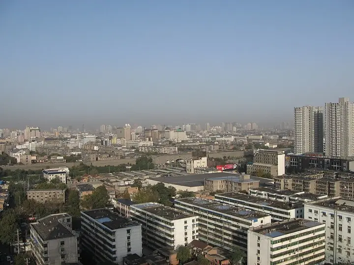
Photo adjustments
Full frame retained; proportionally resized and converted to WebP. No retouching or changes to the photographed subject. Card displays may crop the view.
- Administrative area
- District · 市辖区
- Part of
- Xi’an
- Chinese name
- 新城区
- Local areas
- District guide
Area & population
- Area in the source
- 31.00 km²
- Population · 2019
- 537,300
Source: cited geographic source, as of the dates shown.
History
The district takes its name from a walled compound inside the city. In the Ming dynasty, the founding emperor Zhu Yuanzhang (朱元璋) made his second son Zhu Shuang (朱樉) Prince of Qin, and the prince's palace formed a city of its own, known as the Wangcheng (王城, 'prince's city'). Under the Qing it became a drill ground for the Eight Banners, and a Manchu quarter, a city within the city, was built inside the Ming wall. In January 1927 the compound was renamed the 'Red City' (红城); after the provincial government moved in, governor Shi Jingting (石敬亭) renamed it Xincheng, the 'New City'.
Much older layers lie to the north. In the Tang dynasty the Daming Palace (大明宫) stood here, and the district government describes it as the political and cultural centre of the Tang for more than two hundred years. Xincheng District itself was set up in December 1954, abolished in 1960, restored in 1962, renamed Dongfeng District (东风区) in November 1966 and given back its name in 1972.
What to see
The district divides into three parts along the wall. Inside it is the commercial and financial area around East Street, Jiefang Road (解放路) and North Street; the northern part includes the Daming Palace National Heritage Park (大明宫国家遗址公园); the east is dominated by wholesale markets and military industry.
The district government lists among its historic sites the century-old Yisushe (易俗社), the Eighth Route Army Xi'an Office (八路军驻西安办事处), Revolutionary Park (革命公园), and the 'Yellow Building' (黄楼) associated with the Xi'an Incident. Yongxingfang (永兴坊) is described as the country's first food street themed on intangible cultural heritage.
Getting oriented
Xi'an railway station and the provincial long-distance bus station are in the district, which has long been called the 'gateway of the old city' (古城门户). Metro lines 1 and 6 cross it from east to west, and lines 2, 3 and 4 run north to south. To the east it meets Baqiao (灞桥), to the south Beilin (碑林) and Yanta (雁塔), to the west Lianhu (莲湖) and to the north Weiyang (未央).
Highlights
- Daming Palace National Heritage Park 大明宫国家遗址公园: Site of the Tang dynasty Daming Palace in the northern part of the district.
- Yongxingfang 永兴坊: Described by the district government as China's first food street themed on intangible cultural heritage.
- Eighth Route Army Xi'an Office 八路军驻西安办事处: Called the 'red post station' by the district government.
- Yisushe 易俗社: Century-old institution listed among the district's historic sites.
- Revolutionary Park 革命公园: Listed by the district government as witness to the people of Xi'an defending their home.
Sources for this guide
新城概况-西安市新城区人民政府 · Xincheng District People's Government, Xi'an
历史沿革-西安市新城区人民政府 · Xincheng District People's Government, Xi'an
Original English written from the listed sources and checked sentence by sentence against quoted extracts by a separate reviewer. Updated 2026-09-25.
Explore Xincheng District
Core places to explore, with English and Chinese names.
Places to explore around Xincheng District
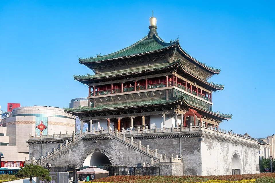 Bell Tower of Xi'an · 西安钟楼. Photo: 2024-06-07 18:39:21.
Bell Tower of Xi'an西安钟楼
The Bell Tower occupies the meeting point of Xi’an’s four main streets. Its timber upper storeys sit on a substantial brick platform, making it an unusually prominent surviving city landmark. First built in 1384, the tower was…
Read the place guide →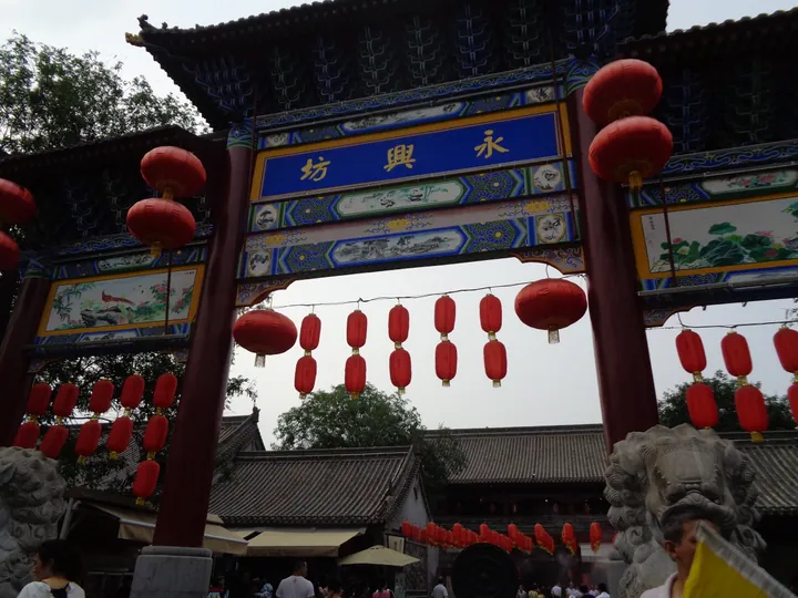 The archway entrance of Yongxingfang in Xi'an's Xincheng District, hung with red lanterns · 西安新城区永兴坊牌楼入口,悬挂红灯笼 Source-recorded photograph date: 2018-07-07 17:21:54.
Yongxingfang Food and Culture Quarter永兴坊
Yongxingfang is a modern food-and-culture quarter inside Zhongshan Gate, designed to introduce traditions from across Shaanxi in a compact space. Its Guanzhong, northern Shaanxi and southern Shaanxi lanes make regional…
Read the place guide →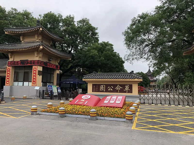 Entrance of Revolution Park in Xi’an. Photograph date recorded by the source: 2021-06-15 10:22:55.
Revolution Park革命公园
Revolution Park was created in 1927 to commemorate civilians and soldiers who died during the 1926 siege of Xi’an. Its burial mounds and memorial architecture give the green space a purpose beyond recreation. The central…
Read the place guide →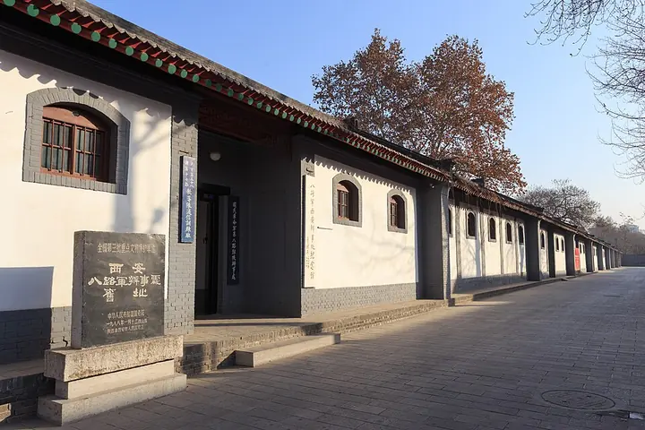 The former Eighth Route Army office in Xi’an · 八路军西安办事处旧址 Photograph date recorded by the source: 4 January 2014, 09:44:59.
Eighth Route Army Xi’an Office Memorial八路军西安办事处纪念馆
The Eighth Route Army’s Xi’an office occupied the western courtyard of Qixianzhuang, a compact residential compound near Beixin Street. From 1937 to 1946 it served as a liaison and supply base connecting Communist forces with…
Read the place guide →Plan your visit
Getting there
Xincheng District is about 4 km in a straight line from central Xi’an. Search for 新城区 in a map app to find stations and your accommodation.
Where to stay →Build your route
Bell Tower of Xi'an and Yongxingfang Food and Culture Quarter are about 2 km apart in a straight line. The linked place guides have entrance and visit details.
Continue with Xi’an →More in Xi’an
Sources & geographic information
Administrative names and parent areas: Official geographic directory · Reference date 2026-09-06.
Photo: Bell Tower of Xi'an · xiquinhosilva · CC BY 2.0. Converted to WebP and resized without changing the subject or cropping the source frame.

Photo: Yongxingfang Food and Culture Quarter · Liuxingy · CC BY-SA 4.0. Full frame retained; proportionally resized and converted to WebP. No retouching or changes to the photographed subject. Card displays may crop the view.

Photo: Revolution Park · 木靈芝 · CC BY-SA 4.0. Full frame retained; proportionally resized and converted to WebP. No retouching or changes to the photographed subject. Card displays may crop the view.

Photo: Eighth Route Army Xi’an Office Memorial · Zhangzhugang · CC BY-SA 4.0. Full frame retained; proportionally resized and converted to WebP. No retouching or changes to the photographed subject. Card displays may crop the view.

Map data © OpenStreetMap contributors. Pins mark approximate centres, not entrances or boundaries.